Difference between revisions of "2012-09-17 47 -122"
imported>Thomcat ([live picture] Marked the pavement [http://www.openstreetmap.org/?lat=47.87240667&lon=-122.22184802&zoom=16&layers=B000FTF @47.8724,-122.2218]) |
imported>FippeBot m (Location) |
||
| (9 intermediate revisions by 2 users not shown) | |||
| Line 1: | Line 1: | ||
| − | |||
| − | |||
| − | |||
| − | |||
| − | |||
| − | |||
| − | |||
| − | |||
| − | |||
| − | |||
{{meetup graticule | {{meetup graticule | ||
| lat=47 | | lat=47 | ||
| lon=-122 | | lon=-122 | ||
| date=2012-09-17 | | date=2012-09-17 | ||
| + | | graticule_name=Seattle | ||
| + | | graticule_link=Seattle, Washington | ||
}} | }} | ||
| − | |||
__NOTOC__ | __NOTOC__ | ||
== Location == | == Location == | ||
| − | + | On a jogging/dog path in Mill Creek | |
== Participants == | == Participants == | ||
| − | + | *[[User:Thomcat|Thomcat]] | |
| − | + | *[[User:Boomzilla|Boomzilla]] | |
== Plans == | == Plans == | ||
| − | + | I stopped on my way to work; can stop again on my way home to meet with [[User:Boomzilla|Boomzilla]] --[[User:Thomcat|Thomcat]] 12:32, 17 September 2012 (EDT) | |
| + | |||
| + | : Cool. I'll probably swing by around 3 or 4 PM. I see it's on the North Creek Trail. So, I'll probably hang out for a bit nearby with a book and enjoy the weather. [[User:Boomzilla|Boomzilla]] 13:56, 17 September 2012 (EDT) | ||
| + | |||
| + | :: Should be out of here in 15 minutes; will hopefully be there between 3:45 and 4. --[[User:Thomcat|Thomcat]] 18:14, 17 September 2012 (EDT) | ||
| − | == Expedition == | + | == Expedition #1 == |
| − | |||
| + | As usual, I checked the eleven geohash sites just before heading out the door. Hello, this one isn't too far off my route - and I have to stop at Costco anyhow! | ||
*The geohash is not far off my path to work today. -- [[User:Thomcat|Thomcat]] [http://www.openstreetmap.org/?lat=47.82515529&lon=-122.31112084&zoom=16&layers=B000FTF @47.8252,-122.3111] 07:33, 17 September 2012 (PDT) | *The geohash is not far off my path to work today. -- [[User:Thomcat|Thomcat]] [http://www.openstreetmap.org/?lat=47.82515529&lon=-122.31112084&zoom=16&layers=B000FTF @47.8252,-122.3111] 07:33, 17 September 2012 (PDT) | ||
| Line 35: | Line 30: | ||
*Less than 3 kilometers from my place. I'll try to visit. [[User:Boomzilla|Boomzilla]] 10:38, 17 September 2012 (EDT) | *Less than 3 kilometers from my place. I'll try to visit. [[User:Boomzilla|Boomzilla]] 10:38, 17 September 2012 (EDT) | ||
| − | + | The closest approach was from a residential complex with a thing for security apparently. I parked in a visitor spot and read a sign indicating that I needed a guest pass - where am I supposed to get that?!? No matter, I can always plead I was looking for the office... down this convenient dog path. Unfortunately, the path led to a gate to the path proper - locked of course. Sheesh! | |
| − | + | ||
| + | Leaving the complex, I drove up the road to some alternate parking. Across the road was a nice path leading down to the paved trail - listen folks, this is geohashing with style! Passed a nice doggie bag dispenser, then down into the trees. GPS signal was a little spotty, but if you stood still it would eventually level out. I was afraid for a moment that the spot would actually be back inside the fence I just drove around to be on the outside of - but it finally settled down onto the trail (which matches the google aerial photo). | ||
| + | |||
| + | I chalked the pavement and snapped pictures, then snapped a few more on the way out to help with telling my story. I then stopped at Frost Doughnuts on the way to work, only a few minutes later than normal. | ||
| + | |||
| + | == Expedition #2 == | ||
| + | |||
| + | Managed to get out of work shortly after 3:30, but northbound traffic was the usual not-good. Parked in the same spot and skedaddled down the trail, arriving shortly before 4. Further up (or south) on the trail was a picnic table I didn't see this morning, and there was Boomzilla. We wandered to the spot, compared to aerial photos I printed on the color printer at work, and left an Active Geohasher banner also. Meetup, first and eighty-fourth geohash achieved. | ||
== Photos == | == Photos == | ||
| − | |||
| − | |||
| − | |||
<gallery perrow="5"> | <gallery perrow="5"> | ||
Image:2012-09-17_47_-122_07-55-07-173.jpg | No access this way... [http://www.openstreetmap.org/?lat=47.87200358&lon=-122.22136602&zoom=16&layers=B000FTF @47.8720,-122.2214] | Image:2012-09-17_47_-122_07-55-07-173.jpg | No access this way... [http://www.openstreetmap.org/?lat=47.87200358&lon=-122.22136602&zoom=16&layers=B000FTF @47.8720,-122.2214] | ||
| + | |||
| + | Image:2012-09-17 47 -122 HashParking.jpg | Overflow Geohash Parking | ||
| + | Image:2012-09-17 47 -122 Approach.jpg | Alternate approach, not hampered by locked gate | ||
| + | Image:2012-09-17 47 -122 LookingAway.jpg | Other end of the approach path | ||
| + | Image:2012-09-17 47 -122 LookingTowards.jpg | Geohash is just around the bend | ||
| + | Image:2012-09-17 47 -122 Dogs.jpg | Popular area for dog walking | ||
Image:2012-09-17_47_-122_08-02-42-901.jpg | At the spot [http://www.openstreetmap.org/?lat=47.87240720&lon=-122.22184626&zoom=16&layers=B000FTF @47.8724,-122.2218] | Image:2012-09-17_47_-122_08-02-42-901.jpg | At the spot [http://www.openstreetmap.org/?lat=47.87240720&lon=-122.22184626&zoom=16&layers=B000FTF @47.8724,-122.2218] | ||
| + | |||
| + | Image:2012-09-17 47 -122 Chalked.jpg | The XKCD marks | ||
Image:2012-09-17_47_-122_08-07-55-287.jpg | Marked the pavement [http://www.openstreetmap.org/?lat=47.87240667&lon=-122.22184802&zoom=16&layers=B000FTF @47.8724,-122.2218] | Image:2012-09-17_47_-122_08-07-55-287.jpg | Marked the pavement [http://www.openstreetmap.org/?lat=47.87240667&lon=-122.22184802&zoom=16&layers=B000FTF @47.8724,-122.2218] | ||
| + | |||
| + | Image:2012-09-17 47 -122 Uploading.jpg | Timed photo - Thomcat uploading on geohashdroid | ||
| + | |||
| + | |||
| + | Image:2012-09-17_47_-122_16-08-18-503.jpg | Successful meetup [http://www.openstreetmap.org/?lat=47.87235146&lon=-122.22197302&zoom=16&layers=B000FTF @47.8724,-122.2220] | ||
| + | |||
| + | Image:2012-09-17-boomzilla-01.JPG | The hash might have been slightly behind this fence, on private property | ||
| + | |||
| + | Image:2012-09-17-boomzilla-02.JPG | My first geohash! -[[User:Boomzilla|Boomzilla]] | ||
</gallery> | </gallery> | ||
| Line 55: | Line 71: | ||
<!-- Add any achievement ribbons you earned below, or remove this section --> | <!-- Add any achievement ribbons you earned below, or remove this section --> | ||
| − | |||
| − | |||
| − | |||
| − | |||
| − | |||
| − | |||
| − | |||
| − | |||
| − | |||
| − | |||
| − | |||
[[Category:Expeditions]] | [[Category:Expeditions]] | ||
| − | |||
[[Category:Expeditions with photos]] | [[Category:Expeditions with photos]] | ||
| − | |||
| − | |||
| − | |||
| − | |||
| − | |||
[[Category:Coordinates reached]] | [[Category:Coordinates reached]] | ||
| − | + | {{location|US|WA|SN}} | |
| − | |||
| − | |||
| − | |||
| − | |||
| − | |||
| − | |||
| − | |||
| − | |||
| − | |||
| − | |||
| − | |||
| − | |||
| − | |||
| − | |||
| − | |||
| − | |||
| − | |||
Latest revision as of 06:09, 13 August 2019
| Mon 17 Sep 2012 in Seattle: 47.8723680, -122.2218072 geohashing.info google osm bing/os kml crox |
Location
On a jogging/dog path in Mill Creek
Participants
Plans
I stopped on my way to work; can stop again on my way home to meet with Boomzilla --Thomcat 12:32, 17 September 2012 (EDT)
- Cool. I'll probably swing by around 3 or 4 PM. I see it's on the North Creek Trail. So, I'll probably hang out for a bit nearby with a book and enjoy the weather. Boomzilla 13:56, 17 September 2012 (EDT)
- Should be out of here in 15 minutes; will hopefully be there between 3:45 and 4. --Thomcat 18:14, 17 September 2012 (EDT)
Expedition #1
As usual, I checked the eleven geohash sites just before heading out the door. Hello, this one isn't too far off my route - and I have to stop at Costco anyhow!
- The geohash is not far off my path to work today. -- Thomcat @47.8252,-122.3111 07:33, 17 September 2012 (PDT)
- Less than 3 kilometers from my place. I'll try to visit. Boomzilla 10:38, 17 September 2012 (EDT)
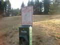
The closest approach was from a residential complex with a thing for security apparently. I parked in a visitor spot and read a sign indicating that I needed a guest pass - where am I supposed to get that?!? No matter, I can always plead I was looking for the office... down this convenient dog path. Unfortunately, the path led to a gate to the path proper - locked of course. Sheesh!
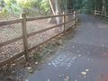
Leaving the complex, I drove up the road to some alternate parking. Across the road was a nice path leading down to the paved trail - listen folks, this is geohashing with style! Passed a nice doggie bag dispenser, then down into the trees. GPS signal was a little spotty, but if you stood still it would eventually level out. I was afraid for a moment that the spot would actually be back inside the fence I just drove around to be on the outside of - but it finally settled down onto the trail (which matches the google aerial photo).
I chalked the pavement and snapped pictures, then snapped a few more on the way out to help with telling my story. I then stopped at Frost Doughnuts on the way to work, only a few minutes later than normal.
Expedition #2
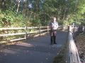
Managed to get out of work shortly after 3:30, but northbound traffic was the usual not-good. Parked in the same spot and skedaddled down the trail, arriving shortly before 4. Further up (or south) on the trail was a picnic table I didn't see this morning, and there was Boomzilla. We wandered to the spot, compared to aerial photos I printed on the color printer at work, and left an Active Geohasher banner also. Meetup, first and eighty-fourth geohash achieved.
Photos

No access this way... @47.8720,-122.2214
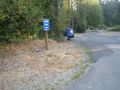
Overflow Geohash Parking
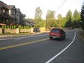
Alternate approach, not hampered by locked gate
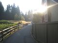
Other end of the approach path
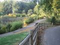
Geohash is just around the bend
Popular area for dog walking

At the spot @47.8724,-122.2218
The XKCD marks
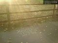
Marked the pavement @47.8724,-122.2218
Timed photo - Thomcat uploading on geohashdroid

Successful meetup @47.8724,-122.2220

The hash might have been slightly behind this fence, on private property

My first geohash! -Boomzilla


