Difference between revisions of "2012-09-20 43 -79"
imported>Splitdipless |
m (More specific location) |
||
| (4 intermediate revisions by 2 users not shown) | |||
| Line 17: | Line 17: | ||
__NOTOC__ | __NOTOC__ | ||
== Location == | == Location == | ||
| − | + | The hash was in the south side (eastbound) lane of Tangmere Crescent in Markham, neighbourhood of Miliken. | |
== Participants == | == Participants == | ||
| Line 26: | Line 26: | ||
== Expedition == | == Expedition == | ||
| − | + | In the morning, I grabbed my GPS and camera before going to work. Then it hit me at work... When was the last time I used my GPS? Luckily, there was still some charge left on the batteries. Enough to find the geohashing point. Google maps pointed me most of the way, getting me to at least a place I could park on Tangmere Cresent in Miliken. I got out of my car for the rest. I could have done a Speed Racer, but decided to get out for some better pictures. | |
| − | |||
| − | |||
| − | |||
== Photos == | == Photos == | ||
| − | |||
| − | |||
| − | |||
<gallery perrow="5"> | <gallery perrow="5"> | ||
| + | Image:2012-09-20 43 -79 0.7 A.jpg | Right on the money. | ||
| + | Image:2012-09-20 43 -79 0.7 B.jpg | Stupid grin: check. | ||
| + | Image:2012-09-20 43 -79 0.7 C.jpg | Not a bad little neighbourhood. | ||
</gallery> | </gallery> | ||
== Achievements == | == Achievements == | ||
{{#vardefine:ribbonwidth|800px}} | {{#vardefine:ribbonwidth|800px}} | ||
| − | + | Nothing new. | |
| − | |||
| − | |||
[[Category:Expeditions]] | [[Category:Expeditions]] | ||
| − | -- | + | <!--[[Category:Expeditions with photos]]--> |
| − | [[Category:Expeditions with photos]] | ||
| − | |||
| − | |||
| − | --> | ||
| − | |||
| − | |||
[[Category:Coordinates reached]] | [[Category:Coordinates reached]] | ||
| − | + | {{location|CA|ON|YO}} | |
| − | |||
| − | |||
| − | |||
| − | |||
| − | |||
| − | |||
| − | |||
| − | |||
| − | |||
| − | |||
| − | |||
| − | |||
| − | |||
| − | |||
| − | |||
| − | |||
| − | |||
Latest revision as of 23:58, 9 August 2020
| Thu 20 Sep 2012 in 43,-79: 43.8309051, -79.2950249 geohashing.info google osm bing/os kml crox |
Location
The hash was in the south side (eastbound) lane of Tangmere Crescent in Markham, neighbourhood of Miliken.
Participants
Plans
I have a free evening, why not Geohash a point in surburbia? Splitdipless 10:33, 20 September 2012 (EDT)
Expedition
In the morning, I grabbed my GPS and camera before going to work. Then it hit me at work... When was the last time I used my GPS? Luckily, there was still some charge left on the batteries. Enough to find the geohashing point. Google maps pointed me most of the way, getting me to at least a place I could park on Tangmere Cresent in Miliken. I got out of my car for the rest. I could have done a Speed Racer, but decided to get out for some better pictures.
Photos
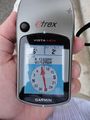
Right on the money.

Stupid grin: check.
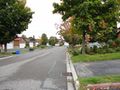
Not a bad little neighbourhood.


Achievements
Nothing new.