Difference between revisions of "2012-10-12 43 -89"
imported>Swensonj (make template) |
imported>FippeBot m (Location) |
||
| (9 intermediate revisions by 2 users not shown) | |||
| Line 1: | Line 1: | ||
| − | |||
| − | |||
| − | |||
| − | |||
| − | |||
| − | |||
| − | |||
| − | |||
| − | |||
| − | |||
{{meetup graticule | {{meetup graticule | ||
| lat=43 | | lat=43 | ||
| Line 15: | Line 5: | ||
}} | }} | ||
| − | |||
__NOTOC__ | __NOTOC__ | ||
== Location == | == Location == | ||
| − | + | Farmland northwest of Lake Mendota, near Governor Nelson State Park | |
== Participants == | == Participants == | ||
| − | + | [[User:swensonj|SwensonJ]] | |
| − | |||
== Plans == | == Plans == | ||
| − | + | ||
| + | [[User:swensonj|SwensonJ]] is driving to Madison for a 3:00 appointment. He'll try to swing by the hash on the way there, sometime in the early afternoon. | ||
== Expedition == | == Expedition == | ||
| − | + | This was a vacation day at our school, but I was on the road to give a presentation at Madison College. The hashpoint is about a 15-minute drive from the campus, which is over an hour from home, so a visit to the hash was definitely in order. | |
| − | + | It was a beautiful day to drive; the temperature was about (50 F / 10 C), and the trees were changing colors. After a quick shopping detour, I headed north around Lake Mendota. The farmers were out in the field; they clearly thought I was an idiot, but a harmless one, and gave me permission to walk across their land for a few minutes. | |
| − | + | ||
| + | Luckily, the camera batteries died only after I'd gotten the GPS proof photo. There were extras in the car, but I was in a hurry by this time. I got back on the road about 2:15 p.m., and headed for my appointment. My route took me right past the entrance to Governor Nelson State Park -- and then past a gas station. I stopped to change into clean jeans -- and they had squishies! The gas station was Trader Gus, at (43.150941, -89.414291), a distance of just under 4km from the hash. The brand name was [[There_might_be_alligators!_consolation_prize|Alligator Ice]]: I got blue raspberry flavor. | ||
| + | |||
| + | I got to Madison College at about 3 p.m. and gave my talk. If anyone happens to like puzzles, I talked about properties of sequences like (3, 13, 1113, 3113, 132113, 1113122113, ...), and they made a video: it is, or will someday be, available [http://clubs.madisoncollege.edu/mathclub/Lectures/Lec118000000TBD/default.htm#Anchor-MATC-49575 here]. | ||
== Photos == | == Photos == | ||
| − | <!-- | + | <gallery perrow="3"> |
| − | Image:2012- | + | Image:2012-10-12 43 -89 Tractor.jpg | The tractor driver gave me permission to journey on |
| − | -- | + | Image:2012-10-12 43 -89 Field.jpg | View from parking place across the hashpoint |
| − | + | Image:2012-10-12 43 -89 Proof.jpg | I got there! | |
| + | Image:2012-10-12 43 -89 Park.jpg | A hash one mile to the east would have been more fun (and earned the [[Admit One Geohash]] achievement) | ||
| + | Image:2012-10-12 43 -89 Squishy.jpg | Cheers! | ||
| + | Image:2012-10-12 43 -89 MATC.jpg | Madison College, main entrance | ||
</gallery> | </gallery> | ||
== Achievements == | == Achievements == | ||
{{#vardefine:ribbonwidth|800px}} | {{#vardefine:ribbonwidth|800px}} | ||
| − | |||
| + | {{land geohash | ||
| + | |||
| + | | latitude = 43 | ||
| + | | longitude = -89 | ||
| + | | date = 2012-10-12 | ||
| + | | name = SwensonJ | ||
| + | | image = 2012-10-12_43_-89 Proof.jpg | ||
| − | + | }} | |
| − | |||
| − | |||
| − | + | {{GeoSquishy FirstSip | |
| − | <!-- | + | |
| − | + | | latitude = 43 | |
| + | | longitude = -89 | ||
| + | | date = 2012-10-12 | ||
| + | | name = SwensonJ | ||
| + | | image = 2012-10-12_43_-89 Squishy.jpg | ||
| + | <!-- 2 stars: | ||
| + | distance from hash (43.1332032,-89.4555498) | ||
| + | to squishy (43.150941,-89.414291) | ||
| + | is 3.8896 km. | ||
| + | Tools: | ||
| + | http://itouchmap.com/latlong.html | ||
| + | http://www2.nau.edu/~cvm/latlongdist.html | ||
--> | --> | ||
| + | }} | ||
| + | {{User:Swensonj/template/SquishyStars | ||
| + | | latitude = 43 | ||
| + | | longitude = -89 | ||
| + | | date = 2012-10-12 | ||
| + | | name = SwensonJ | ||
| + | | image = 2012-10-12_43_-89 Squishy.jpg | ||
| + | | pointsnumber = 2 | ||
| + | }} | ||
| + | {{Minesweeper geohash | ||
| + | |||
| + | | graticule = Dubuque, Iowa | ||
| + | | ranknumber = 3 | ||
| + | | n = true | ||
| + | | ne = true | ||
| + | | w = true | ||
| + | | name = SwensonJ | ||
| + | |||
| + | }} | ||
| − | |||
[[Category:Expeditions]] | [[Category:Expeditions]] | ||
| − | |||
[[Category:Expeditions with photos]] | [[Category:Expeditions with photos]] | ||
| − | |||
| − | |||
| − | |||
| − | |||
| − | |||
[[Category:Coordinates reached]] | [[Category:Coordinates reached]] | ||
| − | + | {{location|US|WI|DA}} | |
| − | |||
| − | |||
| − | |||
| − | |||
| − | |||
| − | |||
| − | |||
| − | |||
| − | |||
| − | |||
| − | |||
| − | |||
| − | |||
| − | |||
| − | |||
| − | |||
| − | |||
Latest revision as of 06:29, 13 August 2019
| Fri 12 Oct 2012 in 43,-89: 43.1332032, -89.4555498 geohashing.info google osm bing/os kml crox |
Location
Farmland northwest of Lake Mendota, near Governor Nelson State Park
Participants
Plans
SwensonJ is driving to Madison for a 3:00 appointment. He'll try to swing by the hash on the way there, sometime in the early afternoon.
Expedition
This was a vacation day at our school, but I was on the road to give a presentation at Madison College. The hashpoint is about a 15-minute drive from the campus, which is over an hour from home, so a visit to the hash was definitely in order.
It was a beautiful day to drive; the temperature was about (50 F / 10 C), and the trees were changing colors. After a quick shopping detour, I headed north around Lake Mendota. The farmers were out in the field; they clearly thought I was an idiot, but a harmless one, and gave me permission to walk across their land for a few minutes.
Luckily, the camera batteries died only after I'd gotten the GPS proof photo. There were extras in the car, but I was in a hurry by this time. I got back on the road about 2:15 p.m., and headed for my appointment. My route took me right past the entrance to Governor Nelson State Park -- and then past a gas station. I stopped to change into clean jeans -- and they had squishies! The gas station was Trader Gus, at (43.150941, -89.414291), a distance of just under 4km from the hash. The brand name was Alligator Ice: I got blue raspberry flavor.
I got to Madison College at about 3 p.m. and gave my talk. If anyone happens to like puzzles, I talked about properties of sequences like (3, 13, 1113, 3113, 132113, 1113122113, ...), and they made a video: it is, or will someday be, available here.
Photos
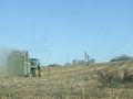
The tractor driver gave me permission to journey on
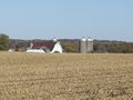
View from parking place across the hashpoint
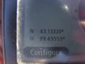
I got there!
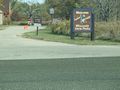
A hash one mile to the east would have been more fun (and earned the Admit One Geohash achievement)
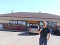
Cheers!
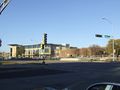
Madison College, main entrance


Achievements
SwensonJ earned the Land geohash achievement
|
SwensonJ earned the First Sip GeoSquishy Achievement
|
SwensonJ earned 2 GeoSquishy stars
|
SwensonJ achieved level 3 of the Minesweeper Geohash achievement
|