Difference between revisions of "2012-10-21 48 11"
imported>Zertrin m (→Location) |
m (Location correction) |
||
| (4 intermediate revisions by 2 users not shown) | |||
| Line 18: | Line 18: | ||
I departed at about 4:15 p.m. and drove my way by bike in the late afternoon sun, under blue sky and mild temperature, quite enjoyable for October in Munich. | I departed at about 4:15 p.m. and drove my way by bike in the late afternoon sun, under blue sky and mild temperature, quite enjoyable for October in Munich. | ||
| − | Nothing very special during the trip. As I was planning to get the Tron achievement, near the beginning of the trip I avoided an intersection | + | Nothing very special during the trip. As I was planning to get the Tron achievement, near the beginning of the trip I avoided an intersection which I knew I would have to cross on the way back. Then I simply followed the navigation proposed by my GPS device, cutting through the forest. While driving in the pathways of the forest, I encountered many people, mostly families, enjoying a nice Sunday getaway in the forest. |
Again in anticipation of the Tron constraint, I chose to divert my route from the navigation a little before arriving at the hashpoint. | Again in anticipation of the Tron constraint, I chose to divert my route from the navigation a little before arriving at the hashpoint. | ||
| Line 24: | Line 24: | ||
I reached the hashpoint quite easily, as luckily even under the trees my GPS had good accuracy today, paying attention to remember exactly where I walked from the point I left my bike until recovering it from another direction. | I reached the hashpoint quite easily, as luckily even under the trees my GPS had good accuracy today, paying attention to remember exactly where I walked from the point I left my bike until recovering it from another direction. | ||
| − | The way back was quite uneventful, but I had difficulties in the last meters not to cross my path, due to a wrong | + | The way back was quite uneventful, but I had difficulties in the last meters not to cross my path, due to a wrong choice of path at the very beginning. Fortunately, by driving about 100 meters on the pedestrian sidewalk I was able to avoid my path and reach home again. |
[[Image:{{{image|2012-10-21 48 11 Tracklog with zooms.png}}}|700px]] | [[Image:{{{image|2012-10-21 48 11 Tracklog with zooms.png}}}|700px]] | ||
| Line 30: | Line 30: | ||
== Tracklog == | == Tracklog == | ||
http://www.openstreetmap.org/trace/1340344/data | http://www.openstreetmap.org/trace/1340344/data | ||
| + | |||
| + | http://www.everytrail.com/view_trip.php?trip_id=1847246&code=ec252a8535a7167d364a8013fe108fb5 | ||
== Photos == | == Photos == | ||
| Line 37: | Line 39: | ||
Image:2012-10-21 48 11 Zertrin at coords.jpg | Me at the hashpoint | Image:2012-10-21 48 11 Zertrin at coords.jpg | Me at the hashpoint | ||
Image:2012-10-21 48 11 The hashpoint.jpg | The haspoint | Image:2012-10-21 48 11 The hashpoint.jpg | The haspoint | ||
| − | Image:2012-10-21 48 11 close up on the hashpoint.jpg | Close up on the | + | Image:2012-10-21 48 11 close up on the hashpoint.jpg | Close up on the hashpoint |
Image:2012-10-21 48 11 Map of the Kasten forest.jpg | Map of the Kasten forest | Image:2012-10-21 48 11 Map of the Kasten forest.jpg | Map of the Kasten forest | ||
Image:2012-10-21 48 11 Tracklog with zooms.png | Tracklog map | Image:2012-10-21 48 11 Tracklog with zooms.png | Tracklog map | ||
| Line 48: | Line 50: | ||
| longitude = 11 | | longitude = 11 | ||
| date = 2012-10-21 | | date = 2012-10-21 | ||
| − | | tracklog = http://www.openstreetmap.org/ | + | | tracklog = http://www.openstreetmap.org/user/Zrkr/traces/1340344 |
| possessive = his | | possessive = his | ||
| name = [[User:Zertrin|Zertrin]] | | name = [[User:Zertrin|Zertrin]] | ||
| Line 64: | Line 66: | ||
[[Category:Expeditions with photos]] | [[Category:Expeditions with photos]] | ||
[[Category:Coordinates reached]] | [[Category:Coordinates reached]] | ||
| + | {{location|DE|BY|M}} | ||
Latest revision as of 20:17, 16 May 2020
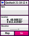
| Sun 21 Oct 2012 in 48,11: 48.0883282, 11.4197975 geohashing.info google osm bing/os kml crox |
Location
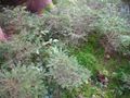
In the Kasten forest on the south-west of Munich, in the trees about 40 meters from the nearest path.
Participants
Plans
Sunday's hash is not that far from Munich and weather looks promising. I'll maybe try to reach it by bike in the afternoon. — Zertrin 06:48, 20 October 2012 (EDT)
Expedition
I departed at about 4:15 p.m. and drove my way by bike in the late afternoon sun, under blue sky and mild temperature, quite enjoyable for October in Munich.
Nothing very special during the trip. As I was planning to get the Tron achievement, near the beginning of the trip I avoided an intersection which I knew I would have to cross on the way back. Then I simply followed the navigation proposed by my GPS device, cutting through the forest. While driving in the pathways of the forest, I encountered many people, mostly families, enjoying a nice Sunday getaway in the forest.
Again in anticipation of the Tron constraint, I chose to divert my route from the navigation a little before arriving at the hashpoint.
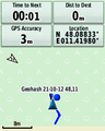
I reached the hashpoint quite easily, as luckily even under the trees my GPS had good accuracy today, paying attention to remember exactly where I walked from the point I left my bike until recovering it from another direction.
The way back was quite uneventful, but I had difficulties in the last meters not to cross my path, due to a wrong choice of path at the very beginning. Fortunately, by driving about 100 meters on the pedestrian sidewalk I was able to avoid my path and reach home again.

Tracklog
http://www.openstreetmap.org/trace/1340344/data
http://www.everytrail.com/view_trip.php?trip_id=1847246&code=ec252a8535a7167d364a8013fe108fb5
Photos
Coordinates to be reached...
Mission accomplished!
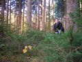
Me at the hashpoint
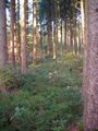
The haspoint
Close up on the hashpoint
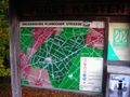
Map of the Kasten forest
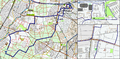
Tracklog map


Achievements
Zertrin earned the Tron achievement
|
Zertrin earned the Consecutive geohash achievement
|