Difference between revisions of "2008-05-24 40 -105"
From Geohashing
imported>Jeffhutch103 (New page: {{meetup graticule | map=<map lat="40" lon="-105" date="2008-05-24" /> | lat=40 | lon=-105 | date=2008-05-24 }} thumb|250 px|May 24 - Snow! 40.126648°,-105.5...) |
m (fix, sorry) |
||
| (26 intermediate revisions by 12 users not shown) | |||
| Line 10: | Line 10: | ||
40.126648°,-105.547534° | 40.126648°,-105.547534° | ||
| − | |||
| − | We left the parking lot meeting place at about 4:10pm and made our way up the trail. We met up with some other geohashers that were coming down from the geohash point. Half of them joined us to return to the point. While at the location, we played Twister, | + | =Summary= |
| + | The [[Fort Collins, Colorado|Fort Collins]] coordinates ({{egl|2008-05-24|40|-106|text=40.126648°,-105.547534°}}) were reached by many people. It was in the Roosevelt National Forest (at the edge of the Indian Peaks Wilderness) at an altitude of 9,610 feet. Snow made the trail difficult to navigate. | ||
| + | |||
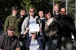
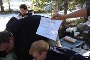
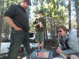
| + | We left the parking lot [http://maps.google.com/maps?q=40.121239,+-105.523931&ie=UTF8&oe=utf-8&client=firefox-a&ll=40.121079,-105.523837&spn=0.001183,0.00294&t=h&z=19&iwloc=addr meeting place] at about 4:10pm and made our way up the trail. We met up with some other geohashers that were coming down from the geohash point. Half of them joined us to return to the point. While at the location, we played Twister, chess, built miniature snowmen as markers and took a group photo. | ||
| + | |||
| + | ==[[Achievements]] earned:== | ||
| + | *[[Land geohash]] | ||
| + | *[[Snowman Geohash]] | ||
| + | *[[Twister Geohash]] | ||
| + | *[[MNIMB Geohash]] | ||
| + | |||
| + | ==Geohashers that made it: (11 total)== | ||
| + | [[User:Jeffhutch103|Jeff]]<br> | ||
| + | Michael<br> | ||
| + | [http://www.keeportoss.org Mario]<br> | ||
| + | [[User:Doubt|Doug]]<br> | ||
| + | Jaeger<br> | ||
| + | Humblik<br> | ||
| + | Mike<br> | ||
| + | Celeste<br> | ||
| + | [[User:The-r-gonaut|Ryan]]<br> | ||
| + | |||
| + | ==Pictures:== | ||
| + | <gallery widths="200px" perrow=3> | ||
| + | Image:DSC01997.JPG | ||
| + | Image:DSC01972.JPG | ||
| + | Image:2521125393 d0240a6421 b.jpg | ||
| + | Image:2521092847 f3b9fa2f17 b.jpg | ||
| + | Image:2520791282 4a0cc53ce2 o.jpg | ||
| + | </gallery> | ||
| + | |||
| + | [http://picasaweb.google.com/jeffhutch103/Geohashing52408 Jeff's Pictures 5-24-08]<br> | ||
| + | [http://www.flickr.com/photos/doubt72/tags/geohashdenver080524/ Doug's Pictures]<br> | ||
| + | [http://flickr.com/photos/7128789@N07/sets/72157605245220480/ Michael's Pictures]<br> | ||
| + | |||
| + | |||
| + | [[Category:Expeditions]] | ||
| + | [[Category:Expeditions with photos]] | ||
| + | [[Category:Coordinates reached]] | ||
| + | {{location|US|CO|BO}} | ||
Latest revision as of 18:42, 18 January 2022
| Sat 24 May 2008 in 40,-105: 40.1266480, -105.5475331 geohashing.info google osm bing/os kml crox |
40.126648°,-105.547534°
Summary
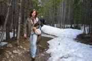
The Fort Collins coordinates (40.126648°,-105.547534°) were reached by many people. It was in the Roosevelt National Forest (at the edge of the Indian Peaks Wilderness) at an altitude of 9,610 feet. Snow made the trail difficult to navigate.
We left the parking lot meeting place at about 4:10pm and made our way up the trail. We met up with some other geohashers that were coming down from the geohash point. Half of them joined us to return to the point. While at the location, we played Twister, chess, built miniature snowmen as markers and took a group photo.
Achievements earned:
Geohashers that made it: (11 total)
Jeff
Michael
Mario
Doug
Jaeger
Humblik
Mike
Celeste
Ryan
