Difference between revisions of "2012-12-09 51 0"
imported>Huinesoron (Creating page) |
imported>FippeBot m (Location) |
||
| (5 intermediate revisions by 2 users not shown) | |||
| Line 1: | Line 1: | ||
| − | |||
| − | |||
| − | |||
| − | |||
| − | |||
| − | |||
| − | |||
| − | |||
| − | |||
| − | |||
{{meetup graticule | {{meetup graticule | ||
| lat=51 | | lat=51 | ||
| Line 14: | Line 4: | ||
| date=2012-12-09 | | date=2012-12-09 | ||
}} | }} | ||
| − | |||
| − | |||
__NOTOC__ | __NOTOC__ | ||
== Location == | == Location == | ||
| − | + | A field just east of Lingfield, Surrey - and within three miles of [[2012-12-09 51 -0|the neighbouring graticule's hashpoint]]. Gotta love that Prime Meridian! | |
== Participants == | == Participants == | ||
| − | + | *[[User:Huinesoron|Huinesoron]] | |
| − | |||
== Plans == | == Plans == | ||
| − | + | [[User:Huinesoron|Huinesoron]] intends to head down sometime Sunday afternoon and hit (or at least stare longingly at) both this and the 51 -0 hashpoint for a [[Multihash]]. | |
| + | |||
| + | For this one in particular, there's also a number of geocaches that, given the wintery trees, may be within sight of the hashpoint, making for a possible [[hash collision achievement]]. | ||
== Expedition == | == Expedition == | ||
| − | + | ''This expedition was Part 2 of an attempted [[Multihash]]. See [[2012-12-09 51 -0]] for the other half.'' | |
| − | + | Two hashes, only a mile or so apart - could there be a better setup for a multihash? Well, apparently yes: I failed to reach [[2012-12-09 51 -0|my first target]], and had to simply hope the second was possible. | |
| − | |||
| − | |||
| − | |||
| − | |||
| − | |||
<gallery perrow="5"> | <gallery perrow="5"> | ||
| + | Image:2012-12-09 51 -0 Multihashcollision.jpg | Look how close they are! | ||
| + | Image:2012-12-09 51 0 LooksMessy.jpg | The second (and last) hash on my tour. | ||
</gallery> | </gallery> | ||
| − | = | + | I hopped back onto the main road and drove east. Was the hash accessible? Could I even spot it? |
| − | + | ||
| − | + | "I think that was it, actually..." | |
| + | |||
| + | Okay: turn around. Head back. It's a field, and it looks good. But where can I park? Not here... not here... not here either... ah, here we go. | ||
| + | |||
| + | It was a long walk back to the hash. But when I got there: success! Relief! '''There was a footpath running into the field.''' That meant I had guaranteed legal access - much better than last time. | ||
| + | |||
| + | <gallery perrow="5"> | ||
| + | Image:2012-12-09 51 0 LongWalkToHash.jpg | Nearby parking is too much to ask, huh? | ||
| + | Image:2012-12-09 51 0 YayAFootpath.jpg | A footpath! That's legal access! | ||
| + | Image:2012-12-09 51 0 ThatsAPathRight.jpg | That... ''is'' a footpath, right? | ||
| + | </gallery> | ||
| + | |||
| + | Not that it was much of a footpath - and the field beyond was worse, freshly-ploughed mud. But in the service of some random numbers and the Internet, I pressed on into the mire. | ||
| + | |||
| + | There was no real way of knowing the precise location of the hash. I hear some people have 'portable computing technology' which lets them pinpoint their location, but I don't believe a word of it. I picked a spot roughly equally distant from the two lines of trees and took the obligatory ridiculous photo. | ||
| + | |||
| + | (Unfortunately, those trees did away with my chance of a [[Hash collision achievement]]; it was a long shot anyway, with the cache in question being about a mile away, but it ''could'' have been technically visible...) | ||
| + | There's not much more to say. I extracted myself from the sea of mud, placed a quirky little sign by the field on the off-chance that anyone noticed, and headed back to the car and my increasingly disgruntled wife. | ||
| − | + | I don't think she appreciated the state of my shoes... | |
| − | |||
| − | |||
| − | < | + | <gallery perrow="5"> |
| − | + | Image:2012-12-09 51 0 OutThere.jpg | The hashpoint is out there in a sea of mud. | |
| − | + | Image:2012-12-09 51 0 StupidGrinInStupidField.jpg | As, a minute later, was I! | |
| − | --> | + | Image:2012-12-09 51 0 HelpfulSign.jpg | Surely this sign will last for generations. |
| + | Image:2012-12-09 51 0 FeetOfClay.jpg | Is there an achievement for ruining your shoes? | ||
| + | </gallery> | ||
| − | + | == Photos == | |
| − | |||
| − | |||
| − | |||
| − | |||
| − | |||
| − | |||
| − | |||
| − | |||
| − | |||
| + | <gallery perrow="5"> | ||
| + | Image:2012-12-09 51 -0 Multihashcollision.jpg | Look how close they are! | ||
| + | Image:2012-12-09 51 0 LooksMessy.jpg | The second (and last) hash on my tour. | ||
| + | Image:2012-12-09 51 0 LongWalkToHash.jpg | Nearby parking is too much to ask, huh? | ||
| + | Image:2012-12-09 51 0 YayAFootpath.jpg | A footpath! That's legal access! | ||
| + | Image:2012-12-09 51 0 ThatsAPathRight.jpg | That... ''is'' a footpath, right? | ||
| + | Image:2012-12-09 51 0 OutThere.jpg | The hashpoint is out there in a sea of mud. | ||
| + | Image:2012-12-09 51 0 StupidGrinInStupidField.jpg | As, a minute later, was I! | ||
| + | Image:2012-12-09 51 0 HelpfulSign.jpg | Surely this sign will last for generations. | ||
| + | Image:2012-12-09 51 0 FeetOfClay.jpg | Is there an achievement for ruining your shoes? | ||
| + | </gallery> | ||
| − | + | == Achievements == | |
| − | |||
| − | |||
| − | |||
| − | |||
| − | |||
| − | |||
| − | |||
| − | + | No new achievements, though I suppose this counts as a [[No Batteries Geohash]]? But so do all of mine so far... | |
| − | |||
| − | |||
| − | |||
| − | [[ | ||
| − | + | [[Category:Expeditions]] | |
| + | [[Category:Coordinates reached]] | ||
| + | {{location|GB|ENG|SRY}} | ||
Latest revision as of 00:09, 14 August 2019
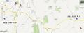
| Sun 9 Dec 2012 in 51,0: 51.1711597, 0.0247772 geohashing.info google osm bing/os kml crox |
Location
A field just east of Lingfield, Surrey - and within three miles of the neighbouring graticule's hashpoint. Gotta love that Prime Meridian!
Participants
Plans
Huinesoron intends to head down sometime Sunday afternoon and hit (or at least stare longingly at) both this and the 51 -0 hashpoint for a Multihash.
For this one in particular, there's also a number of geocaches that, given the wintery trees, may be within sight of the hashpoint, making for a possible hash collision achievement.
Expedition
This expedition was Part 2 of an attempted Multihash. See 2012-12-09 51 -0 for the other half.
Two hashes, only a mile or so apart - could there be a better setup for a multihash? Well, apparently yes: I failed to reach my first target, and had to simply hope the second was possible.
Look how close they are!
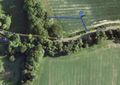
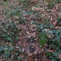
The second (and last) hash on my tour.

I hopped back onto the main road and drove east. Was the hash accessible? Could I even spot it?
"I think that was it, actually..."
Okay: turn around. Head back. It's a field, and it looks good. But where can I park? Not here... not here... not here either... ah, here we go.
It was a long walk back to the hash. But when I got there: success! Relief! There was a footpath running into the field. That meant I had guaranteed legal access - much better than last time.
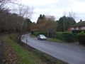
Nearby parking is too much to ask, huh?
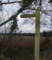
A footpath! That's legal access!
That... is a footpath, right?


Not that it was much of a footpath - and the field beyond was worse, freshly-ploughed mud. But in the service of some random numbers and the Internet, I pressed on into the mire.
There was no real way of knowing the precise location of the hash. I hear some people have 'portable computing technology' which lets them pinpoint their location, but I don't believe a word of it. I picked a spot roughly equally distant from the two lines of trees and took the obligatory ridiculous photo.
(Unfortunately, those trees did away with my chance of a Hash collision achievement; it was a long shot anyway, with the cache in question being about a mile away, but it could have been technically visible...)
There's not much more to say. I extracted myself from the sea of mud, placed a quirky little sign by the field on the off-chance that anyone noticed, and headed back to the car and my increasingly disgruntled wife.
I don't think she appreciated the state of my shoes...
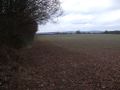
The hashpoint is out there in a sea of mud.

As, a minute later, was I!
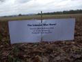
Surely this sign will last for generations.
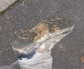
Is there an achievement for ruining your shoes?


Photos
Look how close they are!
The second (and last) hash on my tour.
Nearby parking is too much to ask, huh?
A footpath! That's legal access!
That... is a footpath, right?
The hashpoint is out there in a sea of mud.
As, a minute later, was I!
Surely this sign will last for generations.
Is there an achievement for ruining your shoes?
Achievements
No new achievements, though I suppose this counts as a No Batteries Geohash? But so do all of mine so far...