Difference between revisions of "2012-12-20 62 25"
imported>Tilley m |
imported>FippeBot m (Location) |
||
| (One intermediate revision by one other user not shown) | |||
| Line 26: | Line 26: | ||
[[File:2012-12-20_62_25_DSC1458_2000px_2000px.jpg|300px|thumb|right|At the hashpoint]] | [[File:2012-12-20_62_25_DSC1458_2000px_2000px.jpg|300px|thumb|right|At the hashpoint]] | ||
So, I just waded to the hashpoint, took the picture and wrote XKCD in the snow. The nearest house was really quite near, and there was direct line of sight to the hashpoint, but no one seemed to care that I wandered in their back yard forest. | So, I just waded to the hashpoint, took the picture and wrote XKCD in the snow. The nearest house was really quite near, and there was direct line of sight to the hashpoint, but no one seemed to care that I wandered in their back yard forest. | ||
| + | |||
| + | We continued our way to the [[2012-12-20_62_26|second hashpoint]] of the day.. | ||
== Additional photos == | == Additional photos == | ||
| Line 51: | Line 53: | ||
[[Category:Expeditions with photos]] | [[Category:Expeditions with photos]] | ||
[[Category:Coordinates reached]] | [[Category:Coordinates reached]] | ||
| + | {{location|FI|08}} | ||
Latest revision as of 00:19, 14 August 2019
| Thu 20 Dec 2012 in 62,25: 62.6308743, 25.5324032 geohashing.info google osm bing/os kml crox |
Location
Between Äänekoski and Saarijärvi, according to the map in a forest about 50 m from the nearest house, but the point should be accessible.
Participants
Plans
I was traveling from Keuruu to Kuopio 20.12.2012, passing 4 graticules in this almost directly eastward trip of 200 km. (Yes, our graticules in Finland are very thin, as someone on the IRC noticed). I noted that there were two hashpoints that fell quite nicely on the route, with only 15 km and 6 km detour, respectively, which didn't seem that much. Both points seemed easily accessible, only challenge was presented by the cold weather, almost -20°C, and the fact that I was traveling with my wife and 1-month old daughter.
First I was looking which hashpoint would be the easier to visit, but as we Finns say, "Hunger grows while eating", and I was soon laying plans for the double hash.
Expedition
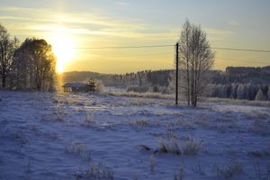
As predicted, temperature was -15°C when we set out from Keuruu. Driving through beautiful country landscape covered with snow and frost, we located the place easily.
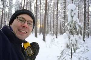
The hashpoint was about 50 meters from the road. Luckily the forest was easily traversable and not bushy like most of the forest we had seen lining the road. There was about 30 cm of snow. Temperature was -19°C and the baby was sleeping so I didn't have the heart to wake her and make her score her first geohash. Maybe she'll hold a grudge against me for that later, we'll see.. Or maybe she'll understand that the summer babies have quite a bit of an advantage in their early geohashing careers and has the patience to still wait for a little longer.
So, I just waded to the hashpoint, took the picture and wrote XKCD in the snow. The nearest house was really quite near, and there was direct line of sight to the hashpoint, but no one seemed to care that I wandered in their back yard forest.
We continued our way to the second hashpoint of the day..
Additional photos
Achievements
Tilley earned the Frozen Geohash Achievement
|


