Difference between revisions of "2013-01-17 52 1"
imported>Sourcerer m (An expedition message sent via Geohash Droid for Android.) |
imported>FippeBot m (Location) |
||
| (5 intermediate revisions by one other user not shown) | |||
| Line 1: | Line 1: | ||
| − | |||
| − | |||
| − | |||
| − | |||
| − | |||
| − | |||
| − | |||
| − | |||
| − | |||
| − | |||
{{meetup graticule | {{meetup graticule | ||
| − | | lat=52 | + | | lat=52 |
| − | | lon=1 | + | | lon=1 |
| − | | date=2013-01-17 | + | | date=2013-01-17 |
| + | | graticule_name=Norwich | ||
| + | | graticule_link=Norwich, United Kingdom | ||
}} | }} | ||
| − | |||
| − | |||
== Location == | == Location == | ||
| − | + | ||
| + | A residential street in Saxmundham, Suffolk, UK. | ||
== Participants == | == Participants == | ||
| − | |||
| − | |||
| − | + | [[User:Sourcerer|Sourcerer]] | |
| − | |||
== Expedition == | == Expedition == | ||
| − | |||
| − | == | + | *Arrived. -- [[User:Sourcerer|Sourcerer]] [http://www.openstreetmap.org/?lat=52.216644287109375&lon=1.4882451295852661&zoom=16&layers=B000FTF @52.2166,1.4882] 17:08, 17 January 2013 (GMT) |
| − | + | ||
| + | Winter geohashes are more difficult but this was a fairly easy one to achieve. | ||
| + | |||
| + | Although the weather was foul and it was snowing, the expedition looked possible. At first the roads were clear but they became more snowy and slippery during the evening with dropping temperatures. The hashpoint was right in the road so it was possible to generate the evidence without leaving the warmth of the car. The car's thermometer stated 0.0 °C so this was an undeserved frozen hash with a twinge of guilt as there was no battling through sub zero difficult terrain. It's nice to get a successful January expedition especially after failing on new year's day in the warmth and sunshine of Tenerife. | ||
== Photos == | == Photos == | ||
| − | + | ||
| − | |||
| − | |||
<gallery perrow="5"> | <gallery perrow="5"> | ||
| + | Image:2012-01-17_52_1_Sourcerer_1.jpg|Location Evidence | ||
| + | Image:2012-01-17_52_1_Sourcerer_2.jpg|Temperature Evidence | ||
</gallery> | </gallery> | ||
== Achievements == | == Achievements == | ||
| − | |||
| − | |||
| + | {{Frozen Geohash | ||
| + | | latitude = 52 | ||
| + | | longitude = 1 | ||
| + | | date = 2013-01-17 | ||
| + | | temperature = 0 °C | ||
| + | | name = Sourcerer | ||
| + | }} | ||
| − | + | {{Sourcerer_links | |
| − | + | | prev = 2013-01-01 28 -16 | |
| − | + | | curr = 2013-01-17 52 1 | |
| − | + | | next = 2013-02-10 52 1 | |
| − | + | | date = 2013-01-17 | |
| − | + | }} | |
| − | |||
| − | |||
| − | |||
[[Category:Expeditions]] | [[Category:Expeditions]] | ||
| − | |||
[[Category:Expeditions with photos]] | [[Category:Expeditions with photos]] | ||
| − | |||
| − | |||
| − | |||
| − | |||
| − | |||
[[Category:Coordinates reached]] | [[Category:Coordinates reached]] | ||
| − | + | {{location|GB|ENG|SFK}} | |
| − | |||
| − | |||
| − | |||
| − | |||
| − | |||
| − | |||
| − | |||
| − | |||
| − | |||
| − | |||
| − | |||
| − | |||
| − | |||
| − | |||
| − | |||
| − | |||
| − | |||
Latest revision as of 11:43, 16 August 2019
| Thu 17 Jan 2013 in Norwich: 52.2166528, 1.4882833 geohashing.info google osm bing/os kml crox |
Contents
Location
A residential street in Saxmundham, Suffolk, UK.
Participants
Expedition
- Arrived. -- Sourcerer @52.2166,1.4882 17:08, 17 January 2013 (GMT)
Winter geohashes are more difficult but this was a fairly easy one to achieve.
Although the weather was foul and it was snowing, the expedition looked possible. At first the roads were clear but they became more snowy and slippery during the evening with dropping temperatures. The hashpoint was right in the road so it was possible to generate the evidence without leaving the warmth of the car. The car's thermometer stated 0.0 °C so this was an undeserved frozen hash with a twinge of guilt as there was no battling through sub zero difficult terrain. It's nice to get a successful January expedition especially after failing on new year's day in the warmth and sunshine of Tenerife.
Photos
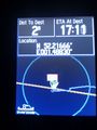
Location Evidence
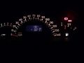
Temperature Evidence


Achievements

Expeditions and Plans
| 2013-01-17 | ||
|---|---|---|
| Swindon, United Kingdom | Jand | Artist's Way, Andover |
| Norwich, United Kingdom | Sourcerer | A residential street in Saxmundham, Suffolk, UK. |
| Braunschweig, Germany | Cbounce, MW | In the middle of a small patch of forest south of Braunschweig |
Sourcerer's Expedition Links
2013-01-01 28 -16 - 2013-01-17 52 1 - 2013-02-10 52 1 - KML file download of Sourcerer's expeditions for use with Google Earth.