Difference between revisions of "2011-10-18 52 1"
imported>MagicIan (→Achievements) |
imported>FippeBot m (Location) |
||
| (One intermediate revision by one other user not shown) | |||
| Line 26: | Line 26: | ||
| name = [[User:MagicIan|MagicIan]] | | name = [[User:MagicIan|MagicIan]] | ||
| count = 2 | | count = 2 | ||
| − | | graticule = | + | | graticule = Norwich, United Kingdom |
| level = County | | level = County | ||
}} | }} | ||
| Line 66: | Line 66: | ||
[[Category:Expeditions with photos]][[Category:Expeditions]][[Category:Coordinates reached]] | [[Category:Expeditions with photos]][[Category:Expeditions]][[Category:Coordinates reached]] | ||
| + | {{location|GB|ENG|SFK}} | ||
Latest revision as of 01:17, 13 August 2019
Location
In a field just outside the town of Framlingham, Suffolk
| Tue 18 Oct 2011 in Norwich: 52.2245873, 1.3494440 geohashing.info google osm bing/os kml crox |
Participants
Expedition
It was a weekday evening. He had nothing particular to do so looked at the location of the hashpoint. It was a nice distance away to give his motorbike a bit of a run out on the country roads, so that's what he did. He parked at the entrance to the field and got within a few metres of the hashpoint before moving on and taking a look around the entrance to the castle. Not surprisingly it was closed!
Achievements
MagicIan earned the Reverse regional achievement
|
Photos

Photo of MagicIan's motorcycle parked near the hashpoint for Tuesday 2011-10-18, 52.224587° 1.349444° (Norwich, United Kingdom)
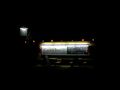
Photo of The Castle Inn near the hashpoint for Tuesday 2011-10-18, 52.224587° 1.349444° (Norwich, United Kingdom)
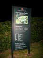
Photo of the information sign for Framlingham Cstle near the hashpoint for Tuesday 2011-10-18, 52.224587° 1.349444° (Norwich, United Kingdom)


