Difference between revisions of "2013-03-24 50 -1"
imported>Macronencer (Create page) |
imported>FippeBot m (Location) |
||
| (9 intermediate revisions by one other user not shown) | |||
| Line 19: | Line 19: | ||
== Location == | == Location == | ||
<!-- where you've surveyed the hash to be --> | <!-- where you've surveyed the hash to be --> | ||
| + | Fritham, New Forest | ||
| + | |||
| + | Short URL for this page - [http://tinyurl.com/ghukmt029 tinyurl.com/ghukmt029] | ||
== Participants == | == Participants == | ||
<!-- who attended: If you link to your wiki user name in this section, your expedition will be picked up by the various statistics generated for geohashing. You may use three tildes ~ as a shortcut to automatically insert the user signature of the account you are editing with. | <!-- who attended: If you link to your wiki user name in this section, your expedition will be picked up by the various statistics generated for geohashing. You may use three tildes ~ as a shortcut to automatically insert the user signature of the account you are editing with. | ||
--> | --> | ||
| + | [[User:Macronencer|Macronencer]] | ||
== Plans == | == Plans == | ||
<!-- what were the original plans --> | <!-- what were the original plans --> | ||
| + | Having been absent from the sport for some time, I wanted to have another go - and this seemed like an easy one to get my teeth into. The weather is going to be cold but dry; there is a parking area next to a lake about 1km from the hash point; there is a nice-looking pub about 1km from the hash point in the other direction - what more could you ask? | ||
== Expedition == | == Expedition == | ||
| − | + | I decided to keep this one to a minimum of time and effort, given the weather. The hash was a 25-minute car journey from my home, and I parked about 1-2km away at Janesmoor pond. I've never seen so many water-filled potholes in a car park before. I think driving to the parking area from the road took almost as long as the journey on the motorway earlier. | |
| + | |||
| + | It was about 2 degrees C, and there was a moderate breeze - so I had to wrap up pretty warm. Saw a few ponies en route and some interesting scenery. | ||
| + | |||
| + | When I reached the hash point it was clear that I would not get into the field as I had hoped. There was a hedge ''and'' a fence... never mind - the GPS read 9m, which I call a win (though I mark it as approximate on my chart). I stood at the roadside and ate a flapjack. At that moment a couple came striding past walking their dogs, and said hello. I think they were a little bemused by my choice of picnic spot! | ||
| + | |||
| + | I had planned to go further on down the road and try out the pub, but I wasn't sure it would be open, so I decided I'd rather get back into the warm and catch up on some sci fi DVDs. Thus, homeward... | ||
| + | |||
| + | My first hash for about three years - wow! | ||
| + | |||
| − | == Tracklog == | + | == Video == |
| + | |||
| + | [http://www.youtube.com/watch?v=fKO0nd6W2iw YouTube video report here] | ||
| + | |||
| + | <!--== Tracklog ==--> | ||
<!-- if your GPS device keeps a log, you may post a link here --> | <!-- if your GPS device keeps a log, you may post a link here --> | ||
| Line 38: | Line 56: | ||
--> | --> | ||
<gallery perrow="5"> | <gallery perrow="5"> | ||
| + | Image:2013-03-24 50 -1 01 Parking.jpg | Parking area. Jane's far moor pond than I am. Apparently. | ||
| + | Image:2013-03-24 50 -1 02 Trees BW.jpg | This just in: Ansel Adams spins in grave. | ||
| + | Image:2013-03-24 50 -1 03 Pony.jpg | Chas (or maybe Dave) stuck one of these in his pocket. That's one impressive pair of jeans. | ||
| + | Image:2013-03-24 50 -1 04 Corner.jpg | More ponies. I can't remember what that building was. It was too cold to hang about inspecting it, frankly! | ||
| + | Image:2013-03-24 50 -1 05 Hash GPS.jpg | 9m. Close enough for jazz. | ||
| + | Image:2013-03-24 50 -1 06 Hash Macronencer.jpg | Stupid grin time. | ||
| + | Image:2013-03-24 50 -1 07 Hash Chuck.jpg | Chuck is hedging his guesses. | ||
</gallery> | </gallery> | ||
| Line 44: | Line 69: | ||
<!-- Add any achievement ribbons you earned below, or remove this section --> | <!-- Add any achievement ribbons you earned below, or remove this section --> | ||
| − | + | [[Category:Expeditions]] | |
| − | + | [[Category:Expeditions with photos]] | |
| − | |||
| − | [[Category: | ||
| − | |||
| − | |||
| − | |||
| − | [[Category: | ||
| − | |||
<!-- An actual expedition: | <!-- An actual expedition: | ||
| − | |||
-- and one or more of -- | -- and one or more of -- | ||
| − | |||
[[Category:Expeditions with videos]] | [[Category:Expeditions with videos]] | ||
[[Category:Expedition without GPS]] | [[Category:Expedition without GPS]] | ||
--> | --> | ||
| − | |||
[[Category:Coordinates reached]] | [[Category:Coordinates reached]] | ||
| − | + | {{location|GB|ENG|HAM}} | |
| − | |||
| − | |||
| − | |||
| − | |||
| − | |||
| − | |||
| − | |||
| − | |||
| − | |||
| − | |||
| − | |||
| − | |||
| − | |||
| − | |||
| − | |||
| − | |||
| − | |||
Latest revision as of 01:33, 14 August 2019
| Sun 24 Mar 2013 in 50,-1: 50.9251623, -1.6613839 geohashing.info google osm bing/os kml crox |
Location
Fritham, New Forest
Short URL for this page - tinyurl.com/ghukmt029
Participants
Plans
Having been absent from the sport for some time, I wanted to have another go - and this seemed like an easy one to get my teeth into. The weather is going to be cold but dry; there is a parking area next to a lake about 1km from the hash point; there is a nice-looking pub about 1km from the hash point in the other direction - what more could you ask?
Expedition
I decided to keep this one to a minimum of time and effort, given the weather. The hash was a 25-minute car journey from my home, and I parked about 1-2km away at Janesmoor pond. I've never seen so many water-filled potholes in a car park before. I think driving to the parking area from the road took almost as long as the journey on the motorway earlier.
It was about 2 degrees C, and there was a moderate breeze - so I had to wrap up pretty warm. Saw a few ponies en route and some interesting scenery.
When I reached the hash point it was clear that I would not get into the field as I had hoped. There was a hedge and a fence... never mind - the GPS read 9m, which I call a win (though I mark it as approximate on my chart). I stood at the roadside and ate a flapjack. At that moment a couple came striding past walking their dogs, and said hello. I think they were a little bemused by my choice of picnic spot!
I had planned to go further on down the road and try out the pub, but I wasn't sure it would be open, so I decided I'd rather get back into the warm and catch up on some sci fi DVDs. Thus, homeward...
My first hash for about three years - wow!
Video
Photos
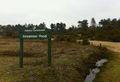
Parking area. Jane's far moor pond than I am. Apparently.
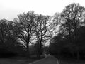
This just in: Ansel Adams spins in grave.
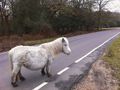
Chas (or maybe Dave) stuck one of these in his pocket. That's one impressive pair of jeans.
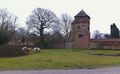
More ponies. I can't remember what that building was. It was too cold to hang about inspecting it, frankly!
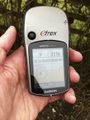
9m. Close enough for jazz.
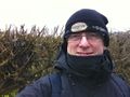
Stupid grin time.
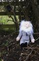
Chuck is hedging his guesses.


