Difference between revisions of "2013-03-13 52 21"
From Geohashing
imported>Norill (Created page with "{{subst:Expedition |lat = 52 |lon = 21 |date = 2013-03-13 }}") |
m (Location correction) |
||
| (5 intermediate revisions by 3 users not shown) | |||
| Line 18: | Line 18: | ||
__NOTOC__ | __NOTOC__ | ||
== Location == | == Location == | ||
| − | + | An island on Vistula river! | |
== Participants == | == Participants == | ||
| − | + | *[[User:Ziemek|Ziemek]] | |
| − | + | *[[User:Ziemba|Ziemba]] | |
| + | *[[User:Norill|Norill]] | ||
| + | |||
== Plans == | == Plans == | ||
| Line 34: | Line 36: | ||
== Photos == | == Photos == | ||
| − | |||
| − | |||
| − | |||
<gallery perrow="5"> | <gallery perrow="5"> | ||
| + | Image:20130313Coords.JPG|As close as we could get... But still too far... | ||
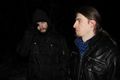
| + | Image:20130313Expedition.JPG|Brave and fearless! | ||
| + | Image:20130313NoSwimming.JPG|Świder islands, nature reserve. NO SWIMMING! | ||
| + | Image:20130313Itsatrap.JPG|It's a TRAP! | ||
| + | Image:20130313Swallowsadness.JPG|Swallow sadness... | ||
</gallery> | </gallery> | ||
| Line 43: | Line 47: | ||
{{#vardefine:ribbonwidth|800px}} | {{#vardefine:ribbonwidth|800px}} | ||
<!-- Add any achievement ribbons you earned below, or remove this section --> | <!-- Add any achievement ribbons you earned below, or remove this section --> | ||
| + | {{My kingdom for a boat | ||
| + | | latitude = 52 | ||
| + | | longitude = 21 | ||
| + | | date = 2013-03-13 | ||
| + | | name = [[User:Ziemek|Ziemek]], [[User:Ziemba|Ziemba]] and [[User:Norill|Norill]] | ||
| + | | image = 20130313NoSwimming.JPG | ||
| + | }} | ||
| − | |||
| − | |||
| − | |||
| − | |||
| − | |||
| − | |||
| − | |||
| − | |||
| − | |||
| − | |||
[[Category:Expeditions]] | [[Category:Expeditions]] | ||
| − | |||
[[Category:Expeditions with photos]] | [[Category:Expeditions with photos]] | ||
| − | |||
| − | |||
| − | |||
| − | |||
| − | |||
| − | |||
| − | |||
[[Category:Coordinates not reached]] | [[Category:Coordinates not reached]] | ||
| − | |||
| − | |||
[[Category:Not reached - Mother Nature]] | [[Category:Not reached - Mother Nature]] | ||
| − | + | {{location|PL|W|PI}} | |
| − | |||
| − | |||
| − | |||
| − | |||
| − | |||
| − | |||
| − | |||
| − | |||
| − | |||
| − | |||
Latest revision as of 20:19, 16 May 2020
| Wed 13 Mar 2013 in 52,21: 52.1101594, 21.1948311 geohashing.info google osm bing/os kml crox |
Location
An island on Vistula river!
Participants
Plans
Expedition
Tracklog
Photos
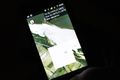
As close as we could get... But still too far...
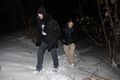
Brave and fearless!
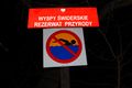
Świder islands, nature reserve. NO SWIMMING!
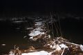
It's a TRAP!
Swallow sadness...


Achievements
Ziemek, Ziemba and Norill earned the My kingdom for a boat consolation prize
|