Difference between revisions of "2013-05-17 -34 138"
From Geohashing
imported>Felix Dance (Added images) |
m (More specific location) |
||
| (6 intermediate revisions by 3 users not shown) | |||
| Line 1: | Line 1: | ||
{{meetup graticule | {{meetup graticule | ||
| − | | lat=- | + | | lat=-34 |
| lon=138 | | lon=138 | ||
| − | | date=2013- | + | | date=2013-05-17 |
}} | }} | ||
== Location == | == Location == | ||
| − | + | Near Henley Beach, Adelaide | |
== Who went == | == Who went == | ||
* [[User:Felix Dance|Felix Dance]] | * [[User:Felix Dance|Felix Dance]] | ||
| − | |||
==Expedition== | ==Expedition== | ||
| + | I noticed this geohash right after work where I was in Adelaide. I had already arranged to have dinner with a school friend at a local pub, so when that finished I jumped onto my bike and hurtled through the streets west towards the water. | ||
| + | Just before reaching the hash I remembered that I'd arranged to call my folks that night, so I stopped at a bus stop, got on the phone and talked to them until I was on 3% battery power. Continuing on my way, I arrived at the hash unceremoniously at about 10pm or so, took some photos, turned around and went back to my flat in the city. | ||
| + | |||
| + | All too easy :) | ||
== Photos == | == Photos == | ||
<gallery perrow="4"> | <gallery perrow="4"> | ||
| − | Image:Geohash 2013 | + | Image:Geohash 2013 05 17 -34 138 Phone Proof.PNG|Phone proof of hash attainment |
| − | + | Image:Geohash 2013 05 17 -34 138 Felix.JPG|Felix at the hash | |
| − | Image:Geohash 2013 | + | }} |
| − | + | ||
| − | |||
</gallery> | </gallery> | ||
| Line 27: | Line 29: | ||
{{Land geohash | {{Land geohash | ||
| − | | latitude = - | + | | latitude = -34 |
| − | | longitude = | + | | longitude = 138 |
| − | | date = 2013- | + | | date = 2013-05-17 |
| name = [[User:Felix Dance|Felix Dance]] | | name = [[User:Felix Dance|Felix Dance]] | ||
| − | | image = | + | | image = Geohash 2013 05 17 -34 138 Felix.JPG|Felix at the hash |
}} | }} | ||
| Line 37: | Line 39: | ||
[[Category:Coordinates reached]] | [[Category:Coordinates reached]] | ||
[[Category:Expeditions with photos]] | [[Category:Expeditions with photos]] | ||
| + | {{location|AU|SA|CS}} | ||
Latest revision as of 12:37, 1 August 2020
| Fri 17 May 2013 in -34,138: -34.9155584, 138.4932517 geohashing.info google osm bing/os kml crox |
Location
Near Henley Beach, Adelaide
Who went
Expedition
I noticed this geohash right after work where I was in Adelaide. I had already arranged to have dinner with a school friend at a local pub, so when that finished I jumped onto my bike and hurtled through the streets west towards the water.
Just before reaching the hash I remembered that I'd arranged to call my folks that night, so I stopped at a bus stop, got on the phone and talked to them until I was on 3% battery power. Continuing on my way, I arrived at the hash unceremoniously at about 10pm or so, took some photos, turned around and went back to my flat in the city.
All too easy :)
Photos
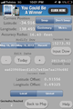
Phone proof of hash attainment
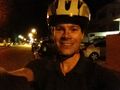
Felix at the hash


Achievement
Felix Dance earned the Land geohash achievement
|