Difference between revisions of "2013-04-29 43 -84"
From Geohashing
imported>Alison (→Location) |
imported>FippeBot m (Location) |
||
| (11 intermediate revisions by one other user not shown) | |||
| Line 21: | Line 21: | ||
== Participants == | == Participants == | ||
| − | + | [[User:Alison|Alison]] ([[User talk:Alison|talk]]) | |
| − | |||
== Plans == | == Plans == | ||
| − | + | I was going to leave from Flint after work and drive up M-13 (aka West County Line Road) to reach the hash point. | |
== Expedition == | == Expedition == | ||
| − | + | Proceeded as planned, except I was stopped at a train tracks near Flushing and my Nexus 7 (which I was using for navigation) kept falling off my dashboard. | |
== Tracklog == | == Tracklog == | ||
| − | + | I took M-13 up to the hash site, and returned by I-75. (no tracklog, I forgot to install 'My Tracks' app beforehand) | |
== Photos == | == Photos == | ||
| Line 38: | Line 37: | ||
--> | --> | ||
<gallery perrow="5"> | <gallery perrow="5"> | ||
| + | File:2013-04-29 43 -84 stopped by train en route.jpg | Stopped by a train in Flushing | ||
| + | File:2013-04-29 43 -84 obsolete sign.jpg | This sign needs updated | ||
| + | File:2013-04-29 43 -84 Saginaw River.jpg | View of the Saginaw River en route | ||
| + | File:2013-04-29 43 -84 squishy.jpg | Squishy! | ||
| + | File:2013-04-29 43 -84 squishy and face.jpg | Squishy and my face! | ||
| + | File:2013-04-29 43 -84 screenshot.png | Proof screenshot! | ||
</gallery> | </gallery> | ||
== Achievements == | == Achievements == | ||
{{#vardefine:ribbonwidth|800px}} | {{#vardefine:ribbonwidth|800px}} | ||
| − | |||
| − | |||
| − | + | {{land geohash | |
| − | + | | latitude = 43 | |
| − | [[ | + | | longitude = -84 |
| + | | date = 2013-04-29 | ||
| + | | name = [[User:Alison|Alison]] ([[User talk:Alison|talk]]) | ||
| + | | image = 2013-04-29 43 -84 squishy and face.jpg | ||
| + | }} | ||
| − | + | {{GeoSquishy FirstSip | |
| − | + | | latitude = 43 | |
| − | [[ | + | | longitude = -84 |
| − | + | | date = 2013-04-29 | |
| + | | name = [[User:Alison|Alison]] ([[User talk:Alison|talk]]) | ||
| + | }} | ||
| − | |||
[[Category:Expeditions]] | [[Category:Expeditions]] | ||
| − | |||
[[Category:Expeditions with photos]] | [[Category:Expeditions with photos]] | ||
| − | |||
| − | |||
| − | |||
| − | |||
| − | |||
[[Category:Coordinates reached]] | [[Category:Coordinates reached]] | ||
| − | + | {{location|US|MI|SG}} | |
| − | |||
| − | |||
| − | |||
| − | |||
| − | |||
| − | |||
| − | |||
| − | |||
| − | |||
| − | |||
| − | |||
| − | |||
| − | |||
| − | |||
| − | |||
| − | |||
| − | |||
Latest revision as of 02:06, 14 August 2019
| Mon 29 Apr 2013 in 43,-84: 43.4161675, -84.0492301 geohashing.info google osm bing/os kml crox |
Location
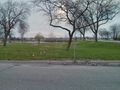
Behind a Clark gas station in Shields, Michigan just west of Saginaw.
Participants
Plans
I was going to leave from Flint after work and drive up M-13 (aka West County Line Road) to reach the hash point.
Expedition
Proceeded as planned, except I was stopped at a train tracks near Flushing and my Nexus 7 (which I was using for navigation) kept falling off my dashboard.
Tracklog
I took M-13 up to the hash site, and returned by I-75. (no tracklog, I forgot to install 'My Tracks' app beforehand)
Photos

Stopped by a train in Flushing

This sign needs updated
View of the Saginaw River en route
Squishy!
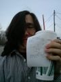
Squishy and my face!
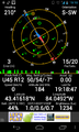
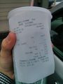
Proof screenshot!


Achievements
Alison (talk) earned the Land geohash achievement
|
Alison (talk) earned the First Sip GeoSquishy Achievement
|