Difference between revisions of "2013-05-22 61 23"
imported>Teukkam (An expedition message sent via Geohash Droid for Android.) |
imported>FippeBot m (Location) |
||
| (5 intermediate revisions by one other user not shown) | |||
| Line 18: | Line 18: | ||
__NOTOC__ | __NOTOC__ | ||
== Location == | == Location == | ||
| + | *Near a power line clearing between Hervanta and Hallila. | ||
<!-- where you've surveyed the hash to be --> | <!-- where you've surveyed the hash to be --> | ||
| Line 23: | Line 24: | ||
<!-- who attended: If you link to your wiki user name in this section, your expedition will be picked up by the various statistics generated for geohashing. You may use three tildes ~ as a shortcut to automatically insert the user signature of the account you are editing with. | <!-- who attended: If you link to your wiki user name in this section, your expedition will be picked up by the various statistics generated for geohashing. You may use three tildes ~ as a shortcut to automatically insert the user signature of the account you are editing with. | ||
--> | --> | ||
| + | [[User:Teukkam|TeukkaM]] ([[User talk:Teukkam|talk]]) | ||
== Plans == | == Plans == | ||
<!-- what were the original plans --> | <!-- what were the original plans --> | ||
| + | Try to reach the hashpoint on foot, following as straight a line as possible. | ||
== Expedition == | == Expedition == | ||
<!-- how it all turned out. your narrative goes here. --> | <!-- how it all turned out. your narrative goes here. --> | ||
| + | The hashpoint landed in a nearby forest, less than a mile away from home. I surveyed the surrounding terrain to be such that this could be reached in an almost straight line, thus qualifying for the [[Juggernaut achievement]]! I studied the route on the topographic map, and deduced that I would have to bypass some buildings pretty close by and cross at least one ditch. | ||
| + | *Near a power line clearing between Hervanta and Hallila. Less than a mile from home, I'll do this juggernaut style! -- [[User:Teukkam|TeukkaM]] ([[User talk:Teukkam|talk]]) 18:05, 21 May 2013 (EEST) | ||
| + | |||
| + | I set my eTrex GPSr to point me straight to the hashpoint and started following the direction arrow as blindly as possible. In the beginning, there conveniently was a power line going parallel to the straight line I was following. Roughly halfway through I emerged from the forest in a rather steep downhill and was facing some private property that appeared to be someone's summer cabin. I was hoping no one would be there, but as I circumnavigated the property, I noticed the owner was standing on a ladder doing some renovation or something. I sincerely hope he didn't spot me so close to his summer cabin. I soon encountered the ditch, which appeared to be of trivial width and I could easily jump over it. The later part of the journey was rather boggy, but I managed not to get my shoes wet. The geocache [http://coord.info/GC3MWWH|GC3MWWH] happened to be almost on the straight line I was following (the small excursion from the straight line in the tracklog is me picking up the geocache). The hashpoint was located near the edge of the forest, with lots of cut trees lying about. I left a foldable paper marker I had crafted beforehand to mark the spot for future visitors, snapped some photos and headed back to the road. On the way back, I witnessed a pine marten chasing a squirrel up a tree, killing it with a swift bite and climbing down with his prey. A rare show of nature indeed. | ||
== Tracklog == | == Tracklog == | ||
<!-- if your GPS device keeps a log, you may post a link here --> | <!-- if your GPS device keeps a log, you may post a link here --> | ||
| + | [[Image:Juggernaut-2013-05-22.png]] | ||
== Photos == | == Photos == | ||
| Line 38: | Line 46: | ||
--> | --> | ||
<gallery perrow="5"> | <gallery perrow="5"> | ||
| + | |||
| + | Image:2013-05-22_61_23_09-51-34-803.jpg | North [http://www.openstreetmap.org/?lat=61.45770000&lon=23.82060000&zoom=16&layers=B000FTF @61.4577,23.8206] | ||
| + | |||
| + | Image:2013-05-22_61_23_09-53-14-690.jpg | East [http://www.openstreetmap.org/?lat=61.45760000&lon=23.82080000&zoom=16&layers=B000FTF @61.4576,23.8208] | ||
| + | |||
| + | Image:2013-05-22_61_23_09-56-05-916.jpg | The message [http://www.openstreetmap.org/?lat=61.45770000&lon=23.82060000&zoom=16&layers=B000FTF @61.4577,23.8206] | ||
</gallery> | </gallery> | ||
| Line 43: | Line 57: | ||
{{#vardefine:ribbonwidth|800px}} | {{#vardefine:ribbonwidth|800px}} | ||
<!-- Add any achievement ribbons you earned below, or remove this section --> | <!-- Add any achievement ribbons you earned below, or remove this section --> | ||
| + | {{Ribbon | ||
| + | |icon = Juggernaut968.png | ||
| + | |color = darkviolet | ||
| + | |user = Teukkam | ||
| + | |achievement = [[Juggernaut achievement]] | ||
| + | |action = reaching a geohash in a straight line (with a deviation of barely 1:25) on [[2013-05-22 61 23|2013-05-22]] | ||
| + | |category = Juggernaut achievement | ||
| + | }} | ||
| − | |||
| − | |||
| − | |||
| − | |||
| − | |||
| − | |||
| − | |||
| − | |||
| − | |||
| − | |||
| − | |||
[[Category:Expeditions]] | [[Category:Expeditions]] | ||
| − | |||
[[Category:Expeditions with photos]] | [[Category:Expeditions with photos]] | ||
| − | |||
| − | |||
| − | |||
| − | |||
| − | |||
[[Category:Coordinates reached]] | [[Category:Coordinates reached]] | ||
| − | + | {{location|FI|11}} | |
| − | |||
| − | |||
| − | |||
| − | |||
| − | |||
| − | |||
| − | |||
| − | |||
| − | |||
| − | |||
| − | |||
| − | |||
| − | |||
| − | |||
| − | |||
| − | |||
| − | |||
Latest revision as of 02:28, 14 August 2019
| Wed 22 May 2013 in 61,23: 61.4576469, 23.8207017 geohashing.info google osm bing/os kml crox |
Location
- Near a power line clearing between Hervanta and Hallila.
Participants
Plans
Try to reach the hashpoint on foot, following as straight a line as possible.
Expedition
The hashpoint landed in a nearby forest, less than a mile away from home. I surveyed the surrounding terrain to be such that this could be reached in an almost straight line, thus qualifying for the Juggernaut achievement! I studied the route on the topographic map, and deduced that I would have to bypass some buildings pretty close by and cross at least one ditch.
- Near a power line clearing between Hervanta and Hallila. Less than a mile from home, I'll do this juggernaut style! -- TeukkaM (talk) 18:05, 21 May 2013 (EEST)
I set my eTrex GPSr to point me straight to the hashpoint and started following the direction arrow as blindly as possible. In the beginning, there conveniently was a power line going parallel to the straight line I was following. Roughly halfway through I emerged from the forest in a rather steep downhill and was facing some private property that appeared to be someone's summer cabin. I was hoping no one would be there, but as I circumnavigated the property, I noticed the owner was standing on a ladder doing some renovation or something. I sincerely hope he didn't spot me so close to his summer cabin. I soon encountered the ditch, which appeared to be of trivial width and I could easily jump over it. The later part of the journey was rather boggy, but I managed not to get my shoes wet. The geocache [1] happened to be almost on the straight line I was following (the small excursion from the straight line in the tracklog is me picking up the geocache). The hashpoint was located near the edge of the forest, with lots of cut trees lying about. I left a foldable paper marker I had crafted beforehand to mark the spot for future visitors, snapped some photos and headed back to the road. On the way back, I witnessed a pine marten chasing a squirrel up a tree, killing it with a swift bite and climbing down with his prey. A rare show of nature indeed.
Tracklog

Photos
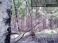
North @61.4577,23.8206
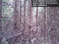
East @61.4576,23.8208
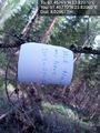
The message @61.4577,23.8206


Achievements
Teukkam earned the Juggernaut achievement
|