Difference between revisions of "2013-04-19 -33 138"
imported>Eldin (Eldin moved page 2013-04-19 -33 138 to 2013-04-19 -34 138: expedition listed in wrong graticule.) |
m (More specific location) |
||
| (2 intermediate revisions by 2 users not shown) | |||
| Line 1: | Line 1: | ||
| − | + | {{meetup graticule | |
| + | | lat=-33 | ||
| + | | lon=138 | ||
| + | | date=2013-04-19 | ||
| + | }} | ||
| + | |||
| + | == Location == | ||
| + | In the Clare Valley, South Australia | ||
| + | |||
| + | == Who went == | ||
| + | * [[User:Felix Dance|Felix Dance]] | ||
| + | * Greg Zani (his co-worker) | ||
| + | |||
| + | ==Expedition== | ||
| + | I was driving back from my work at the Prominent Hill mine site with my coworker, Greg, for a long road trip to Adelaide. During the 800km long journey I told him about geohashing and how awesome it is. Greg suggested we check the coordinates as we came into Adelaide and lo and behold: a geohash was located right near the road in through the Clare Valley - a detour we were already talking about taking. | ||
| + | |||
| + | The Clare Valley is a particularly nice wine-growing region of South Australia and sure enough, approaching the coordinates, the area was very picturesque. Once we pulled over at the road's closest approach we saw the 800m to the hash was a bit iffy - through a vinyard and near a farm house. We instead drove up to the house and I tried to ask permission to enter. | ||
| + | |||
| + | No one being home except for a small yappy dog, we drove further up the dirt track, around a small vinyard and up onto a ridge, parking 200m from the hash. I got out, left Greg on the lookout, climbed the barbed-wire fence and strolled down to the hash taking photos when I got there. I returned nonchalantly to the car where Greg was keen to move on away from any potential conflict. | ||
| + | |||
| + | A very fortuitous geohash location. | ||
| + | |||
| + | == Photos == | ||
| + | <gallery perrow="5"> | ||
| + | Image:Geohash 2013 04 19 -33 138 GPS.PNG|GPS Proof on phone | ||
| + | Image:Geohash 2013 04 19 -33 138 Phone.PNG|Satellite view of hash | ||
| + | Image:Geohash 2013 04 19 -33 138 Felix.JPG|Felix at the hash | ||
| + | Image:Geohash 2013 04 19 -33 138 Ute.JPG|The waiting ute, Greg inside | ||
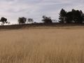
| + | Image:Geohash 2013 04 19 -33 138 Panorama.jpeg|Panorama of Felix at the hash | ||
| + | </gallery> | ||
| + | |||
| + | == Achievement == | ||
| + | |||
| + | {{Land geohash | ||
| + | | latitude = -33 | ||
| + | | longitude = 138 | ||
| + | | date = 2013-04-19 | ||
| + | | name = [[User:Felix Dance|Felix Dance]] | ||
| + | }} | ||
| + | |||
| + | [[Category:Expeditions]] | ||
| + | [[Category:Coordinates reached]] | ||
| + | [[Category:Expeditions with photos]] | ||
| + | {{location|AU|SA|CG}} | ||
Latest revision as of 12:35, 1 August 2020
| Fri 19 Apr 2013 in -33,138: -33.9986016, 138.6729531 geohashing.info google osm bing/os kml crox |
Location
In the Clare Valley, South Australia
Who went
- Felix Dance
- Greg Zani (his co-worker)
Expedition
I was driving back from my work at the Prominent Hill mine site with my coworker, Greg, for a long road trip to Adelaide. During the 800km long journey I told him about geohashing and how awesome it is. Greg suggested we check the coordinates as we came into Adelaide and lo and behold: a geohash was located right near the road in through the Clare Valley - a detour we were already talking about taking.
The Clare Valley is a particularly nice wine-growing region of South Australia and sure enough, approaching the coordinates, the area was very picturesque. Once we pulled over at the road's closest approach we saw the 800m to the hash was a bit iffy - through a vinyard and near a farm house. We instead drove up to the house and I tried to ask permission to enter.
No one being home except for a small yappy dog, we drove further up the dirt track, around a small vinyard and up onto a ridge, parking 200m from the hash. I got out, left Greg on the lookout, climbed the barbed-wire fence and strolled down to the hash taking photos when I got there. I returned nonchalantly to the car where Greg was keen to move on away from any potential conflict.
A very fortuitous geohash location.
Photos
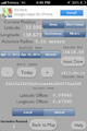
GPS Proof on phone
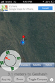
Satellite view of hash
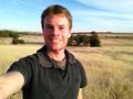
Felix at the hash
The waiting ute, Greg inside
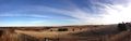
Panorama of Felix at the hash


Achievement
Felix Dance earned the Land geohash achievement
|