Difference between revisions of "2013-07-17 33 -116"
From Geohashing
imported>LucasBrown (→Tracklog) |
imported>FippeBot m (Location) |
||
| (3 intermediate revisions by one other user not shown) | |||
| Line 18: | Line 18: | ||
__NOTOC__ | __NOTOC__ | ||
== Location == | == Location == | ||
| − | + | Amid chaparral off Black Canyon Road west of Lake Sutherland in Ramona, CA | |
== Participants == | == Participants == | ||
[[User:LucasBrown|LucasBrown]] | [[User:LucasBrown|LucasBrown]] | ||
| − | |||
| − | |||
| − | |||
== Expedition == | == Expedition == | ||
| − | + | Details pending | |
== Photos == | == Photos == | ||
| Line 49: | Line 46: | ||
[[Category:Expeditions with photos]] | [[Category:Expeditions with photos]] | ||
[[Category:Coordinates reached]] | [[Category:Coordinates reached]] | ||
| + | {{location|US|CA|SD}} | ||
Latest revision as of 03:12, 14 August 2019
| Wed 17 Jul 2013 in 33,-116: 33.1080719, -116.8214577 geohashing.info google osm bing/os kml crox |
Location
Amid chaparral off Black Canyon Road west of Lake Sutherland in Ramona, CA
Participants
Expedition
Details pending
Photos
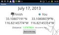
Geohash Droid details page at the hashpoint
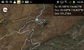
Local map near the hashpoint. Screenshot captured at the closest vehicular approach.
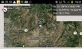
Regional map near the hashpoint


Achievements
LucasBrown earned the GeoTrash Geohash Achievement
|