Difference between revisions of "2013-07-19 46 11"
imported>Werther (Created page with "{{subst:Expedition |lat = 46 |lon = 11 |date = 2013-07-19 }}") |
m (Location correction) |
||
| (6 intermediate revisions by 3 users not shown) | |||
| Line 18: | Line 18: | ||
__NOTOC__ | __NOTOC__ | ||
== Location == | == Location == | ||
| − | + | In a field in Monte Terlago, Trento. | |
== Participants == | == Participants == | ||
| − | + | [[User:Werther|Werther]] | |
| − | |||
== Plans == | == Plans == | ||
| − | + | First reasonable location since I ended my high school exams, glad this happened the day right before I leave for a trip to Corsica! (which means four virgin graticules are waiting for me... though I don't know if and when I will have internet accessibility). | |
| + | Since I will be busy packing up for most of the day, I'll try to go there in the morning. Likely to leave Trento with a 10am Lamar-bound intercity bus. I have half an hour to reach the hash (which sounds enough). On the way back I'll swallow my public transport pride and take a privately operated bus to Sopramonte, from where I'll switch to the city bus network and get back to Trento. | ||
== Expedition == | == Expedition == | ||
| − | + | Nothing particularly exciting- left home, got to the bus station, where I learned that Terlago-bound buses are the only ones that leave from the outside platform. | |
| + | That wasn't something desirable, as I witnessed a large group of screaming children waiting for the bus outside the station. My fears proved right- I shared all the trip to Monte Terlago with them, as they were headed to a lake a few stops after my destination. I was surprised the bus was decently crowded- the Terlago area is quite off any kind of beaten track, and apart from a brief rose to fame around 10 years ago as the stage of a brutal murder, I had only been there once- for an end-of-the-year party in 2010 (a great one, I must say). | ||
| − | + | Once in Monte Terlago, the hash was very easy to find. I got off at the wrong stop because I didn't know where I was supposed to get off, but getting around the village was very easy. A few kids were playing soccer, but the place looked deserted apart from them. The hashpoint was located between a construction site and a field. I thought of reaching the place by the field, which was empty according to Street View, but it was now used for growing corn, so it wasn't definitely an option. The construction area had no trespassing signs, but looked in the exact same state as the Street View picture (which dated October 2011), so I just guessed that whatever was there had been abandoned. I couldn't use the GPS today, as my dad was using it, so I just took a picture of the area around the hash and was satisfied with that. | |
| − | |||
| − | + | I still had plenty of time once I had reached the hashpoint, so I decided to walk to Maso Ariol, a small village nearby, and took the shuttle bus to Sopramonte from there. The bus was almost empty, and the trip a lot quieter... once in Sopramonte, I got off to take bus number 6, and at the bus stop I was greeted with another group of children on a field trip, even louder than the other one. Sharing the bus with them was quite fun though, as one of them knew everything about buses and wouldn't stop talking about them... I annoyed a fair share of friends and classmates with buses as well when I was a kid, so it was a funny blast from the past. They got off in Cadine and were replaced by a much quieter and definitely more pleasant presence, a red-haired girl with a very nice dress. She got off before I did anyways, and thinking I will never see her again, this old xkcd comic popped in my mind: | |
| − | |||
| − | |||
| − | |||
| − | |||
| − | |||
| − | + | http://xkcd.com/304/ | |
| − | |||
| − | |||
| + | Seriously, I should stop falling in ''public transport love''. | ||
| − | + | == Photos == | |
| − | + | <gallery> | |
| − | + | Image:20130719 Monte Terlago 001.jpg | The hashpoint | |
| − | + | Image:20130719 Monte Terlago 002.jpg | Stupid grin | |
| − | + | Image:20130719 Monte Terlago 003.jpg | Nice sight from Monte Terlago | |
| − | + | </gallery> | |
| − | |||
| − | |||
| − | |||
| − | |||
[[Category:Expeditions]] | [[Category:Expeditions]] | ||
| − | + | [[Category:Coordinates reached]] | |
| − | [[Category: | ||
| − | |||
[[Category:Expedition without GPS]] | [[Category:Expedition without GPS]] | ||
| − | + | {{location|IT|TT}} | |
| − | |||
| − | |||
| − | |||
| − | |||
| − | |||
| − | |||
| − | |||
| − | |||
| − | |||
| − | |||
| − | |||
| − | |||
| − | |||
| − | |||
| − | |||
| − | |||
| − | |||
| − | |||
| − | |||
| − | |||
| − | |||
Latest revision as of 15:10, 28 July 2021
| Fri 19 Jul 2013 in 46,11: 46.1108016, 11.0348685 geohashing.info google osm bing/os kml crox |
Location
In a field in Monte Terlago, Trento.
Participants
Plans
First reasonable location since I ended my high school exams, glad this happened the day right before I leave for a trip to Corsica! (which means four virgin graticules are waiting for me... though I don't know if and when I will have internet accessibility). Since I will be busy packing up for most of the day, I'll try to go there in the morning. Likely to leave Trento with a 10am Lamar-bound intercity bus. I have half an hour to reach the hash (which sounds enough). On the way back I'll swallow my public transport pride and take a privately operated bus to Sopramonte, from where I'll switch to the city bus network and get back to Trento.
Expedition
Nothing particularly exciting- left home, got to the bus station, where I learned that Terlago-bound buses are the only ones that leave from the outside platform. That wasn't something desirable, as I witnessed a large group of screaming children waiting for the bus outside the station. My fears proved right- I shared all the trip to Monte Terlago with them, as they were headed to a lake a few stops after my destination. I was surprised the bus was decently crowded- the Terlago area is quite off any kind of beaten track, and apart from a brief rose to fame around 10 years ago as the stage of a brutal murder, I had only been there once- for an end-of-the-year party in 2010 (a great one, I must say).
Once in Monte Terlago, the hash was very easy to find. I got off at the wrong stop because I didn't know where I was supposed to get off, but getting around the village was very easy. A few kids were playing soccer, but the place looked deserted apart from them. The hashpoint was located between a construction site and a field. I thought of reaching the place by the field, which was empty according to Street View, but it was now used for growing corn, so it wasn't definitely an option. The construction area had no trespassing signs, but looked in the exact same state as the Street View picture (which dated October 2011), so I just guessed that whatever was there had been abandoned. I couldn't use the GPS today, as my dad was using it, so I just took a picture of the area around the hash and was satisfied with that.
I still had plenty of time once I had reached the hashpoint, so I decided to walk to Maso Ariol, a small village nearby, and took the shuttle bus to Sopramonte from there. The bus was almost empty, and the trip a lot quieter... once in Sopramonte, I got off to take bus number 6, and at the bus stop I was greeted with another group of children on a field trip, even louder than the other one. Sharing the bus with them was quite fun though, as one of them knew everything about buses and wouldn't stop talking about them... I annoyed a fair share of friends and classmates with buses as well when I was a kid, so it was a funny blast from the past. They got off in Cadine and were replaced by a much quieter and definitely more pleasant presence, a red-haired girl with a very nice dress. She got off before I did anyways, and thinking I will never see her again, this old xkcd comic popped in my mind:
Seriously, I should stop falling in public transport love.
Photos
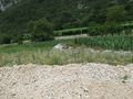
The hashpoint

Stupid grin
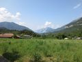
Nice sight from Monte Terlago


