Difference between revisions of "2013-09-14 52 4"
imported>Palmpje (Created page with "{{subst:Expedition |lat = 52 |lon = 4 |date = 2013-09-14}}") |
imported>FippeBot m (Location) |
||
| (7 intermediate revisions by one other user not shown) | |||
| Line 1: | Line 1: | ||
| + | [[Image:2013 09 14 52 4 LookAtHash.JPG|It's there!|thumb|left]] | ||
| − | |||
| − | |||
| − | |||
| − | |||
| − | |||
| − | |||
| − | |||
| − | |||
| − | |||
{{meetup graticule | {{meetup graticule | ||
| lat=52 | | lat=52 | ||
| Line 15: | Line 7: | ||
}} | }} | ||
| − | |||
__NOTOC__ | __NOTOC__ | ||
== Location == | == Location == | ||
| − | + | In residential Leiderdorp near the T-crossing of Mauritssingel and Kleiwarenwaal. | |
== Participants == | == Participants == | ||
| − | + | * [[User:Palmpje|Palmpje]] ([[User talk:Palmpje|talk]]) 11:20, 14 September 2013 (EDT) was there at hash 'o clock | |
| − | |||
== Plans == | == Plans == | ||
| − | + | Drive through a the maximum speed of probably 30 km/h. | |
== Expedition == | == Expedition == | ||
| − | + | I had almost forgotten to look up today's coordinates then I found out that it was very reachable. But it was drizzling all morning so I decided to skip this one. Then it started to clear up and I thought I'd have a go anyway. It was too late to set up the expedition page beforehand but maybe Murfie would be there anyway. | |
| − | + | Initially, I drove to the incorrect place, and when I punched in the coordinates it showed yet another 3km to go. Then I had trouble finding the correct approach but I ended up near the hashpoint at 15:40 to find that it did not really look correct. I decided to do a nearby geocache first and get back to the hashpoint at exactly 4pm. After logging the cache I discovered that earlier I had mistyped the coordinate and now it looked much better so I drove back and was at the hashpoint exactly on time. Made some pictures and left the geohashing flyer from Crox's service. Sadly nobody else showed up. My plans for a speedracer were also abandoned as the hashpoint is not on a road but next to a bicycle path. It was fun going out once again though. | |
| − | |||
== Photos == | == Photos == | ||
| Line 38: | Line 27: | ||
--> | --> | ||
<gallery perrow="5"> | <gallery perrow="5"> | ||
| + | Image:2013_09_14_52_4_NoSpeedRacer.JPG | Did not bring my bicycle | ||
| + | Image:2013_09_14_52_4_Proof.JPG | Close enough | ||
| + | Image:2013_09_14_52_4_Flyer.JPG | This should draw attention | ||
| + | Image:2013_09_14_52_4_TheStands.JPG | No curtains moved | ||
</gallery> | </gallery> | ||
== Achievements == | == Achievements == | ||
{{#vardefine:ribbonwidth|800px}} | {{#vardefine:ribbonwidth|800px}} | ||
| − | + | {{xkcd centurion | count = 1 | name = Palmpje }} | |
| − | + | {{land geohash | latitude = 52 | longitude = 4 | date = 2013-09-14 | name = Palmpje }} | |
| − | |||
| − | |||
| − | |||
| − | |||
| − | |||
| − | |||
| − | |||
| − | |||
| − | |||
| − | |||
[[Category:Expeditions]] | [[Category:Expeditions]] | ||
| − | |||
[[Category:Expeditions with photos]] | [[Category:Expeditions with photos]] | ||
| − | |||
| − | |||
| − | |||
| − | |||
| − | |||
[[Category:Coordinates reached]] | [[Category:Coordinates reached]] | ||
| − | + | {{location|NL|ZH}} | |
| − | |||
| − | |||
| − | |||
| − | |||
| − | |||
| − | |||
| − | |||
| − | |||
| − | |||
| − | |||
| − | |||
| − | |||
| − | |||
| − | |||
| − | |||
| − | |||
| − | |||
Latest revision as of 03:59, 14 August 2019

| Sat 14 Sep 2013 in 52,4: 52.1454788, 4.5319066 geohashing.info google osm bing/os kml crox |
Location
In residential Leiderdorp near the T-crossing of Mauritssingel and Kleiwarenwaal.
Participants
Plans
Drive through a the maximum speed of probably 30 km/h.
Expedition
I had almost forgotten to look up today's coordinates then I found out that it was very reachable. But it was drizzling all morning so I decided to skip this one. Then it started to clear up and I thought I'd have a go anyway. It was too late to set up the expedition page beforehand but maybe Murfie would be there anyway.
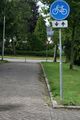
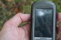
Initially, I drove to the incorrect place, and when I punched in the coordinates it showed yet another 3km to go. Then I had trouble finding the correct approach but I ended up near the hashpoint at 15:40 to find that it did not really look correct. I decided to do a nearby geocache first and get back to the hashpoint at exactly 4pm. After logging the cache I discovered that earlier I had mistyped the coordinate and now it looked much better so I drove back and was at the hashpoint exactly on time. Made some pictures and left the geohashing flyer from Crox's service. Sadly nobody else showed up. My plans for a speedracer were also abandoned as the hashpoint is not on a road but next to a bicycle path. It was fun going out once again though.
Photos
Did not bring my bicycle
Close enough
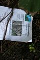
This should draw attention
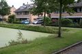
No curtains moved


Achievements
Palmpje earned the xkcd Nullaturion achievement
|
Palmpje earned the Land geohash achievement
|