Difference between revisions of "2013-09-16 53 9"
imported>Hermann |
imported>FippeBot m (Location) |
||
| (3 intermediate revisions by 2 users not shown) | |||
| Line 18: | Line 18: | ||
__NOTOC__ | __NOTOC__ | ||
== Location == | == Location == | ||
| − | + | The hash is located in a former gravel quarry. Today, part of it is a quite extensive playground. The rest of the pit is mostly overgrown by grass and shrubs except for some maintained areas of cut grass. Not very promising for photographic intents. | |
== Participants == | == Participants == | ||
| − | [[User:Hermann|Hermann]] | + | [[User:Hermann|Hermann]] |
== Plans == | == Plans == | ||
| − | + | The hash is quite close to my home, so there was no reason not to go there. However, during the day I almost forgot about it. I remembered just before sunset. My thoughts went like ''Should I bring the camera? Of course, I need to take a picture of the coordinates. The compact camera will do. Or maybe bring the tripod, too? Nah, the big one with the panorama-head is too clunky, it would be in the way when I go shopping for groceries on the way back. Take the small tripod with you. There might be something worth taking a picture.'' | |
== Expedition == | == Expedition == | ||
| − | < | + | So I quickly rode my bike to the quarry pit. I took a wrong turn at one point and felt slightly lost for a short time. Which is weird as I have been to the playground at the bottom of the old quarry numerous times when I was a kid. The area just changed so much in the past years. I arrived at the slope the hash was on, checked the coordinates and was rejoiced noticing I managed to pinpoint the hash's longitude down to the last digit. After a couple of steps uphill I reached the hash and started taking pictures for the proof of location.<br /> |
| + | I did not think of the surroundings to be very photogenic. But the almost setting sun provided a slightly ''golden hour'' lighting, so I setup the small tripod and started taking pictures for a stitched panorama. ''There might be something worth taking a picture.'' And, oh boy, was it worth it. When I was halfway though the panorama, it started raining. I became disgruntled as I had to clean the lens every now and then. But then it happened.<br /> | ||
| + | Double rainbow.<br /> | ||
| + | All the way.<br /> | ||
| + | ''So intense.''<br /> | ||
| + | While technically not being the best panorama I ever took, this is most luckiest one I ever did. Check it out yourself. The high resolution interactive version can be found at http://hehoe.de/hd/pics/Panoramen/gros/kiesgrube/ . Note how the rainbow seems to be between me and the line of trees at the side of the slope. From my point of view the end of the rainbow looked like it was fifty meters away. A friend of mine suggested, I should have taken the opportunity to climb the rainbow. But that would have been ridiculous. I would have wound up at the top of the very same slope and rainbows tend to be slippery when wet and [http://static.nichtlustig.de/toondb/130918.html serious injury] may occur. Geohashing takes you places. In my case to a place where a rainbow appeared while I was already taking pictures for a panorama. I doubt that (as long as I don't start habitually leaving the house for photographic intentions whenever it is rainy) the same thing will happen to me a second time. Thank you, Randall. | ||
== Photos == | == Photos == | ||
| − | < | + | <gallery perrow="4"> |
| − | + | File:Hermann_Geohash_2013-09-16_53_9_P9163936.jpg|Having reached the coordinates,... | |
| − | -- | + | File:Hermann_Geohash_2013-09-16_53_9_P9163939.jpg|...I was like (see picture). |
| − | + | File:Hermann_Geohash_2013-09-16_53_9_P9163938.jpg|But then it started raining... | |
| + | File:Hermann_Geohash_2013-09-16_53_9_P9163940.jpg|...and I was like (see picture). | ||
| + | File:Hermann_Geohash_2013-09-16_53_9_rainbow.jpg|But then I saw this... | ||
| + | File:Hermann_Geohash_2013-09-16_53_9_P9164071.jpg|...and I was so happy (see picture)... | ||
| + | File:Hermann_Geohash_2013-09-16_53_9_P9163941.jpg|...of having brought my tripod. | ||
</gallery> | </gallery> | ||
| + | [[File:Hermann_Geohash_2013-09-16_53_9_rainbow_thumbnail.jpg|frame|center|Panorama with rainbow, clouds and sunset.<br/>High resolution interactive version can be found at http://hehoe.de/hd/pics/Panoramen/gros/kiesgrube/]] | ||
| + | <!-- {{reflist}} -- this is not a Geohashing wiki template --> | ||
[[Category:Expeditions]] | [[Category:Expeditions]] | ||
[[Category:Expeditions with photos]] | [[Category:Expeditions with photos]] | ||
[[Category:Coordinates reached]] | [[Category:Coordinates reached]] | ||
| + | {{location|DE|HH}} | ||
Latest revision as of 04:01, 14 August 2019
| Mon 16 Sep 2013 in 53,9: 53.5768453, 9.7877703 geohashing.info google osm bing/os kml crox |
Location
The hash is located in a former gravel quarry. Today, part of it is a quite extensive playground. The rest of the pit is mostly overgrown by grass and shrubs except for some maintained areas of cut grass. Not very promising for photographic intents.
Participants
Plans
The hash is quite close to my home, so there was no reason not to go there. However, during the day I almost forgot about it. I remembered just before sunset. My thoughts went like Should I bring the camera? Of course, I need to take a picture of the coordinates. The compact camera will do. Or maybe bring the tripod, too? Nah, the big one with the panorama-head is too clunky, it would be in the way when I go shopping for groceries on the way back. Take the small tripod with you. There might be something worth taking a picture.
Expedition
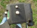
So I quickly rode my bike to the quarry pit. I took a wrong turn at one point and felt slightly lost for a short time. Which is weird as I have been to the playground at the bottom of the old quarry numerous times when I was a kid. The area just changed so much in the past years. I arrived at the slope the hash was on, checked the coordinates and was rejoiced noticing I managed to pinpoint the hash's longitude down to the last digit. After a couple of steps uphill I reached the hash and started taking pictures for the proof of location.
I did not think of the surroundings to be very photogenic. But the almost setting sun provided a slightly golden hour lighting, so I setup the small tripod and started taking pictures for a stitched panorama. There might be something worth taking a picture. And, oh boy, was it worth it. When I was halfway though the panorama, it started raining. I became disgruntled as I had to clean the lens every now and then. But then it happened.
Double rainbow.
All the way.
So intense.
While technically not being the best panorama I ever took, this is most luckiest one I ever did. Check it out yourself. The high resolution interactive version can be found at http://hehoe.de/hd/pics/Panoramen/gros/kiesgrube/ . Note how the rainbow seems to be between me and the line of trees at the side of the slope. From my point of view the end of the rainbow looked like it was fifty meters away. A friend of mine suggested, I should have taken the opportunity to climb the rainbow. But that would have been ridiculous. I would have wound up at the top of the very same slope and rainbows tend to be slippery when wet and serious injury may occur. Geohashing takes you places. In my case to a place where a rainbow appeared while I was already taking pictures for a panorama. I doubt that (as long as I don't start habitually leaving the house for photographic intentions whenever it is rainy) the same thing will happen to me a second time. Thank you, Randall.
Photos
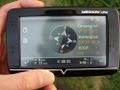
Having reached the coordinates,...

...I was like (see picture).
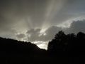
But then it started raining...

...and I was like (see picture).
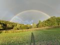
But then I saw this...
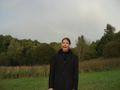
...and I was so happy (see picture)...
...of having brought my tripod.


High resolution interactive version can be found at http://hehoe.de/hd/pics/Panoramen/gros/kiesgrube/