Difference between revisions of "2008-05-26 53 -2"
imported>Tetraburmium (New page: {{meetup graticule | map=<map lat="53" lon="-2" date="2008-05-26" /> | lat=53 | lon=-2 | date=2008-05-26 | graticule_name=Manchester, United Kingdom | graticule_link=Manchester, United Kin...) |
m |
||
| (4 intermediate revisions by 3 users not shown) | |||
| Line 5: | Line 5: | ||
| date=2008-05-26 | | date=2008-05-26 | ||
| graticule_name=Manchester, United Kingdom | | graticule_name=Manchester, United Kingdom | ||
| − | | graticule_link=Manchester, United | + | | graticule_link=Manchester, United Kingdom |
}} | }} | ||
| − | First successful geohash reached in this graticule that has been recorded, reached by M.Bryan at approximately 4pm British Summer Time. The location was a large field just to the north east of Chorley, a town in Lancashire. No other geohashers arrived during the 45 minutes that I lingered there. The weather faded from sunny and warm towards cold and windy during the journey, which was an exciting one, since I had no previous knowledge of the area. By way of map and compass I navigated through the maze of footpaths on a 60minute walk from the train station. | + | First successful geohash reached in this graticule that has been recorded, reached by [[User:Tetraburmium|M.Bryan]] at approximately 4pm British Summer Time. The location was a large field just to the north east of Chorley, a town in Lancashire. No other geohashers arrived during the 45 minutes that I lingered there. The weather faded from sunny and warm towards cold and windy during the journey, which was an exciting one, since I had no previous knowledge of the area. By way of map and compass I navigated through the maze of footpaths on a 60minute walk from the train station. |
On arrival I tried to triangulate my position but was unable to do so because of the dense tree cover on all sides of the field, so I had to settle for approximating my position based on the nearby foot paths and stream. Human contact may have been zero, but there were horses in an adjacent field and I saw two deer far away who ran when I moved closer to photograph them. | On arrival I tried to triangulate my position but was unable to do so because of the dense tree cover on all sides of the field, so I had to settle for approximating my position based on the nearby foot paths and stream. Human contact may have been zero, but there were horses in an adjacent field and I saw two deer far away who ran when I moved closer to photograph them. | ||
| Line 19: | Line 19: | ||
Image:53_n2_05_26_3.jpg|Horses! | Image:53_n2_05_26_3.jpg|Horses! | ||
</gallery> | </gallery> | ||
| + | |||
| + | [[Category:Expeditions]] | ||
| + | [[Category:Expeditions with photos]] | ||
| + | [[Category:Coordinates reached]] | ||
| + | [[Category:Expedition without GPS]] | ||
| + | {{location|GB|ENG|LAN}} | ||
Latest revision as of 12:24, 19 March 2022
| Mon 26 May 2008 in Manchester, United Kingdom: 53.6731281, -2.6073080 geohashing.info google osm bing/os kml crox |
First successful geohash reached in this graticule that has been recorded, reached by M.Bryan at approximately 4pm British Summer Time. The location was a large field just to the north east of Chorley, a town in Lancashire. No other geohashers arrived during the 45 minutes that I lingered there. The weather faded from sunny and warm towards cold and windy during the journey, which was an exciting one, since I had no previous knowledge of the area. By way of map and compass I navigated through the maze of footpaths on a 60minute walk from the train station.
On arrival I tried to triangulate my position but was unable to do so because of the dense tree cover on all sides of the field, so I had to settle for approximating my position based on the nearby foot paths and stream. Human contact may have been zero, but there were horses in an adjacent field and I saw two deer far away who ran when I moved closer to photograph them.
Photos
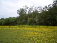
Coordinates + Buttercups.
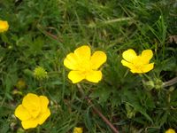
Buttercup Closeup.
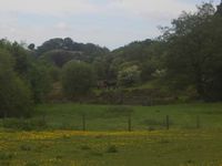
Horses!


