Difference between revisions of "2013-10-24 51 9"
imported>GeorgDerReisende (new expedition to Baunatal) |
m (Replacing http://wiki.xkcd.com/wgh/images/c/c3/2013-10-24_51_9_GeorgDerReisende_map.png with {{filepath:2013-10-24_51_9_GeorgDerReisende_map.png}}) |
||
| (2 intermediate revisions by 2 users not shown) | |||
| Line 20: | Line 20: | ||
== Expedition == | == Expedition == | ||
| − | + | ||
| + | For a first try I started at the bus stop Arnimstraße at 10:24. I walked along Ihringshäuser Straße, stumbled over the rails of the tram, took the bus 27 to Friedenskirche, tram 8 to Bebelplatz, tram 4 to railway station Wilhelmshöhe, walked from there to the bus stop Hasselweg, took the bus 51 to Baunatal-Altenritte. There I had some problems with my Garmin and I noticed, that I had forgotten to program it with the coordinates. Because of all these problems and not finding an internet café, I stopped the adventure and returned home for a second try. | ||
| + | |||
| + | The second try started at the bus stop Arnimstraße at 14:28. I walked along Ihringshäuser Straße, Stifterstraße, Simmershäuser Straße, across Mühlhäuser Platz into Eisenschmiede, where I waited for the bus 27. I took this bus until Virchowstraße, walked to Hasselweg and took the bus 51 until Baunatal-Altenritte. There I walked along Wilhelmhöher Straße, Am Parkstadion, Bahnhofstraße, Niedensteiner Straße to teh fields south of Baunatal. Then I walked to the fields and around the hash along the southern field way. Then I found the hash. As I walked to the hash, the distance marker told me 20 meters, 17, 15, 12, 10, 8, but then suddenly 5 meters behind. So I danced around a little bit and then I found me one meter away. | ||
| + | |||
| + | On the way back I found a bench and made there a rest. Then I walked to the tram station Hünstein, from there I took the tram 5 until Brüder-Grimm-Straße, then tram 6 until Fasanenhof and bus 27 until Arnimstraße. | ||
== Tracklog == | == Tracklog == | ||
| − | + | ||
| + | [[File:2013-10-24 51 9 GeorgDerReisende map.png|1000px]] | ||
== Photos == | == Photos == | ||
| − | + | ||
| − | |||
| − | |||
<gallery perrow="5"> | <gallery perrow="5"> | ||
| + | Image:2013-10-24 51 9 GeorgDerReisende 2168.jpg | the adventure begins | ||
| + | Image:2013-10-24 51 9 GeorgDerReisende 2169.jpg | some old houses of Baunatal-Altenritte | ||
| + | Image:2013-10-24 51 9 GeorgDerReisende 2179.jpg | some old houses of Baunatal-Großenritte | ||
| + | Image:2013-10-24 51 9 GeorgDerReisende 2185.jpg | tractors have priority on narrow fieldways | ||
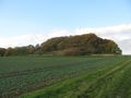
| + | Image:2013-10-24 51 9 GeorgDerReisende 2205.jpg | on the field to the right is the hash | ||
| + | Image:2013-10-24 51 9 GeorgDerReisende 2208.jpg | proof1 | ||
| + | Image:2013-10-24 51 9 GeorgDerReisende 2209.jpg | proof2 | ||
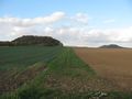
| + | Image:2013-10-24 51 9 GeorgDerReisende 2211.jpg | this hill has the name ''Holzbürgel'' | ||
| + | Image:2013-10-24 51 9 GeorgDerReisende 2213.jpg | view to the west, the Langenberge | ||
| + | Image:2013-10-24 51 9 GeorgDerReisende 2215.jpg | view to the east, the Volkswagen plant | ||
| + | Image:2013-10-24 51 9 GeorgDerReisende 2217.jpg | view to the east | ||
| + | Image:2013-10-24 51 9 GeorgDerReisende 2219.jpg | view to the south, the Schwalm | ||
| + | Image:2013-10-24 51 9 GeorgDerReisende 2227.jpg | view to Bauntal in the sun | ||
| + | Image:2013-10-24 51 9 GeorgDerReisende 2259.jpg | grin | ||
| + | Image:2013-10-24 51 9 GeorgDerReisende 2266.jpg | the Untere Sommerbachstraße in Baunatal | ||
| + | Image:2013-10-24 51 9 GeorgDerReisende 2290.jpg | the adventure ends | ||
| + | Image:2013-10-24 51 9 GeorgDerReisende map.png | the log | ||
</gallery> | </gallery> | ||
| Line 36: | Line 57: | ||
<!-- Add any achievement ribbons you earned below, or remove this section --> | <!-- Add any achievement ribbons you earned below, or remove this section --> | ||
| + | {{Tron | latitude = 51 | longitude = 9 | date = 2013-10-24 | tracklog = {{filepath:2013-10-24_51_9_GeorgDerReisende_map.png}} | possessive = his | name = GeorgDerReisende }} | ||
| − | + | {{Public transport geohash | latitude = 51 | longitude = 9 | date = 2013-10-24 | busline = bus 27 & 51 | name = GeorgDerReisende }} | |
| − | |||
| − | |||
| − | + | [[Category:Expeditions]] | |
| − | |||
| − | [[Category: | ||
| − | |||
| − | |||
| − | |||
| − | |||
[[Category:Expeditions with photos]] | [[Category:Expeditions with photos]] | ||
| − | + | ||
| − | |||
| − | |||
| − | |||
| − | |||
[[Category:Coordinates reached]] | [[Category:Coordinates reached]] | ||
| − | + | {{location|DE|HE|KS}} | |
| − | |||
| − | |||
| − | |||
| − | |||
| − | |||
| − | |||
| − | |||
| − | |||
| − | |||
| − | |||
| − | |||
| − | |||
| − | |||
| − | |||
| − | |||
| − | |||
| − | |||
Latest revision as of 12:58, 19 February 2020
| Thu 24 Oct 2013 in 51,9: 51.2386708, 9.3858468 geohashing.info google osm bing/os kml crox |
Location
on or nearby a fieldway south of Baunatal
Participants
Plans
to go there by public transport, may be a Tron achievement
Expedition
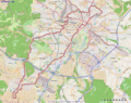
For a first try I started at the bus stop Arnimstraße at 10:24. I walked along Ihringshäuser Straße, stumbled over the rails of the tram, took the bus 27 to Friedenskirche, tram 8 to Bebelplatz, tram 4 to railway station Wilhelmshöhe, walked from there to the bus stop Hasselweg, took the bus 51 to Baunatal-Altenritte. There I had some problems with my Garmin and I noticed, that I had forgotten to program it with the coordinates. Because of all these problems and not finding an internet café, I stopped the adventure and returned home for a second try.
The second try started at the bus stop Arnimstraße at 14:28. I walked along Ihringshäuser Straße, Stifterstraße, Simmershäuser Straße, across Mühlhäuser Platz into Eisenschmiede, where I waited for the bus 27. I took this bus until Virchowstraße, walked to Hasselweg and took the bus 51 until Baunatal-Altenritte. There I walked along Wilhelmhöher Straße, Am Parkstadion, Bahnhofstraße, Niedensteiner Straße to teh fields south of Baunatal. Then I walked to the fields and around the hash along the southern field way. Then I found the hash. As I walked to the hash, the distance marker told me 20 meters, 17, 15, 12, 10, 8, but then suddenly 5 meters behind. So I danced around a little bit and then I found me one meter away.
On the way back I found a bench and made there a rest. Then I walked to the tram station Hünstein, from there I took the tram 5 until Brüder-Grimm-Straße, then tram 6 until Fasanenhof and bus 27 until Arnimstraße.
Tracklog

Photos
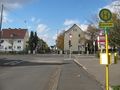
the adventure begins
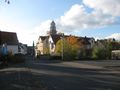
some old houses of Baunatal-Altenritte
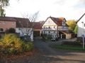
some old houses of Baunatal-Großenritte
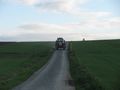
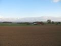
tractors have priority on narrow fieldways
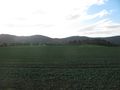
on the field to the right is the hash
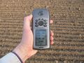
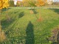
proof1
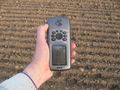
proof2
this hill has the name Holzbürgel
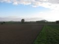
view to the west, the Langenberge
view to the east, the Volkswagen plant
view to the east
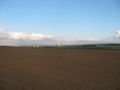
view to the south, the Schwalm
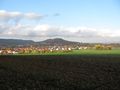
view to Bauntal in the sun
grin
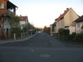
the Untere Sommerbachstraße in Baunatal
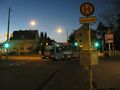
the adventure ends
the log


Achievements
GeorgDerReisende earned the Tron achievement
|
GeorgDerReisende earned the Public transport geohash achievement
|