Difference between revisions of "2013-12-13 49 -121"
imported>Rex Wolf (Created expedition page) |
m (More specific location) |
||
| (4 intermediate revisions by 2 users not shown) | |||
| Line 13: | Line 13: | ||
| lon=-121 | | lon=-121 | ||
| date=2013-12-13 | | date=2013-12-13 | ||
| + | | graticule_name=Chilliwack | ||
| + | | graticule_link=Chilliwack, British Columbia | ||
}} | }} | ||
| Line 19: | Line 21: | ||
== Location == | == Location == | ||
<!-- where you've surveyed the hash to be --> | <!-- where you've surveyed the hash to be --> | ||
| + | In a field north of Yale Road, between Annis Road and Agassiz. | ||
== Participants == | == Participants == | ||
<!-- who attended: If you link to your wiki user name in this section, your expedition will be picked up by the various statistics generated for geohashing. You may use three tildes ~ as a shortcut to automatically insert the user signature of the account you are editing with. | <!-- who attended: If you link to your wiki user name in this section, your expedition will be picked up by the various statistics generated for geohashing. You may use three tildes ~ as a shortcut to automatically insert the user signature of the account you are editing with. | ||
--> | --> | ||
| + | * [[User:Rex Wolf|Rex Wolf]] ([[User talk:Rex Wolf|talk]]) | ||
== Plans == | == Plans == | ||
<!-- what were the original plans --> | <!-- what were the original plans --> | ||
| + | I really had no plans for this expedition. I was working in Abbotsford, finished up early, went to drive a little further east to get gas, and decided on the spur of the moment to drive even further out to Chilliwack! | ||
== Expedition == | == Expedition == | ||
<!-- how it all turned out. your narrative goes here. --> | <!-- how it all turned out. your narrative goes here. --> | ||
| + | I missed my first turn off the highway at Annis Road, so I ended up continuing on to Bridal Falls. Backtracked a little, but it wasn't too difficult to get to the hash. | ||
| + | |||
| + | The hashpoint turned out to be at a tree farm of sorts. I parked in the lot out front, and since I didn't see any sort of No Trespassing sign, I decided to take a peek around. It looked like high winds had been in the area recently, as many of the trees seemed to have fallen over in their pots. | ||
| + | |||
| + | After a bit of circling through very wet clay, I located the hashpoint, beside the edge of where the trees were clustered together. Had it been warmer and drier outside, I might have continued exploring the open field further back from the road, but as it was, I was just glad to claim the Multihash and head back home! | ||
== Tracklog == | == Tracklog == | ||
<!-- if your GPS device keeps a log, you may post a link here --> | <!-- if your GPS device keeps a log, you may post a link here --> | ||
| + | [[:Image:Rex-Chilliwack-2013-12-13-tracklog.png|Rex's tracklog as PNG.]] | ||
== Photos == | == Photos == | ||
| Line 38: | Line 49: | ||
--> | --> | ||
<gallery perrow="5"> | <gallery perrow="5"> | ||
| + | Image:Rex-Chilliwack-2013-12-13-1.JPG | Welcome to the tree farm! | ||
| + | Image:Rex-Chilliwack-2013-12-13-2.JPG | It's been windy lately. | ||
| + | Image:Rex-Chilliwack-2013-12-13-3.PNG | GPS readout. | ||
| + | Image:Rex-Chilliwack-2013-12-13-4.JPG | More trees being propogated. | ||
| + | Image:Rex-Chilliwack-2013-12-13-5.JPG | Looking out to an empty field. | ||
| + | Image:Rex-Chilliwack-2013-12-13-6.JPG | There's a barn in the other direction. | ||
| + | Image:Rex-Chilliwack-2013-12-13-7.JPG | Stupid Grin™! | ||
</gallery> | </gallery> | ||
| Line 46: | Line 64: | ||
<!-- =============== USEFUL CATEGORIES FOLLOW ================ | <!-- =============== USEFUL CATEGORIES FOLLOW ================ | ||
| − | Delete the next line ONLY if you have chosen the appropriate categories below. If you are unsure, don't worry. People will read your report and help you with the classification. | + | Delete the next line ONLY if you have chosen the appropriate categories below. If you are unsure, don't worry. People will read your report and help you with the classification. |
[[Category:New report]] | [[Category:New report]] | ||
| + | --> | ||
<!-- Potential categories. Please include all the ones appropriate to your expedition --> | <!-- Potential categories. Please include all the ones appropriate to your expedition --> | ||
| Line 54: | Line 73: | ||
--> | --> | ||
| − | <!-- An actual expedition: | + | <!-- An actual expedition: --> |
[[Category:Expeditions]] | [[Category:Expeditions]] | ||
| − | -- and one or more of -- | + | <!-- and one or more of --> |
[[Category:Expeditions with photos]] | [[Category:Expeditions with photos]] | ||
| + | <!-- | ||
[[Category:Expeditions with videos]] | [[Category:Expeditions with videos]] | ||
[[Category:Expedition without GPS]] | [[Category:Expedition without GPS]] | ||
--> | --> | ||
| − | <!-- if you reached your coords: | + | <!-- if you reached your coords: --> |
[[Category:Coordinates reached]] | [[Category:Coordinates reached]] | ||
| − | + | <!-- or if you failed :( | |
[[Category:Coordinates not reached]] | [[Category:Coordinates not reached]] | ||
-- and a reason -- | -- and a reason -- | ||
| Line 82: | Line 102: | ||
(Don't forget to delete this final close comment marker) --> | (Don't forget to delete this final close comment marker) --> | ||
| + | {{location|CA|BC|FV}} | ||
Latest revision as of 00:03, 10 August 2020
| Fri 13 Dec 2013 in Chilliwack: 49.1877842, -121.8032356 geohashing.info google osm bing/os kml crox |
Location
In a field north of Yale Road, between Annis Road and Agassiz.
Participants
Plans
I really had no plans for this expedition. I was working in Abbotsford, finished up early, went to drive a little further east to get gas, and decided on the spur of the moment to drive even further out to Chilliwack!
Expedition
I missed my first turn off the highway at Annis Road, so I ended up continuing on to Bridal Falls. Backtracked a little, but it wasn't too difficult to get to the hash.
The hashpoint turned out to be at a tree farm of sorts. I parked in the lot out front, and since I didn't see any sort of No Trespassing sign, I decided to take a peek around. It looked like high winds had been in the area recently, as many of the trees seemed to have fallen over in their pots.
After a bit of circling through very wet clay, I located the hashpoint, beside the edge of where the trees were clustered together. Had it been warmer and drier outside, I might have continued exploring the open field further back from the road, but as it was, I was just glad to claim the Multihash and head back home!
Tracklog
Photos
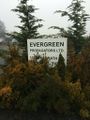
Welcome to the tree farm!
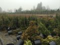
It's been windy lately.
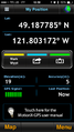
GPS readout.
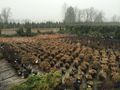
More trees being propogated.
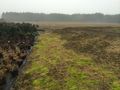
Looking out to an empty field.
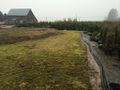
There's a barn in the other direction.

Stupid Grin™!


