Difference between revisions of "2013-12-25 35 -117"
imported>Bravissimo594 (→Location: Added rough location) |
imported>FippeBot m (Location) |
||
| (10 intermediate revisions by 2 users not shown) | |||
| Line 1: | Line 1: | ||
| − | |||
| − | |||
| − | |||
| − | |||
| − | |||
| − | |||
| − | |||
| − | |||
| − | |||
| − | |||
{{meetup graticule | {{meetup graticule | ||
| lat=35 | | lat=35 | ||
| Line 19: | Line 9: | ||
== Location == | == Location == | ||
<!-- where you've surveyed the hash to be --> | <!-- where you've surveyed the hash to be --> | ||
| − | About 20 km north of Barstow ... somewhere in BLM desert land. | + | About 20 km north of Barstow ... somewhere in BLM desert land. [[Ridgecrest, California|Ridgecrest]] graticule. |
== Participants == | == Participants == | ||
<!-- who attended: If you link to your wiki user name in this section, your expedition will be picked up by the various statistics generated for geohashing. You may use three tildes ~ as a shortcut to automatically insert the user signature of the account you are editing with. | <!-- who attended: If you link to your wiki user name in this section, your expedition will be picked up by the various statistics generated for geohashing. You may use three tildes ~ as a shortcut to automatically insert the user signature of the account you are editing with. | ||
--> | --> | ||
| + | |||
| + | * [[User:Bravissimo594|Bravissimo594]] | ||
| + | * [[User:Boppy5|Boppy5]] | ||
== Plans == | == Plans == | ||
<!-- what were the original plans --> | <!-- what were the original plans --> | ||
| + | We were going to try this one if the timing worked out after hitting the meetup points in [[2013-12-25_35_-119|Bakersfield]] and [[2013-12-25_35_-118|Tehachapi]]. | ||
== Expedition == | == Expedition == | ||
<!-- how it all turned out. your narrative goes here. --> | <!-- how it all turned out. your narrative goes here. --> | ||
| + | === [[User:Bravissimo594|Bravissimo594]] === | ||
| + | Leaving the [[2013-12-25_35_-118|Techachapi meetup point]] at about 3:00pm, we knew we would race darkness to get to this third point in the same day. Going north on Irwin Road, we got to Copper City Road, a left turn onto a dirt road, about 20 minutes before sunset. We had 13 or 14 miles of dirt-road driving to do (which would not, by itself, have stopped us), followed by somewhere between a half mile and one mile of hiking in the dark winter desert. | ||
| − | + | We played it safe and turned around to wait for another accessible day in the [[Ridgecrest,_California|Ridgecrest]] graticule, thwarted by Mother Nature's sunset darkness. (Accessibility is tough given how much of the graticule is covered by the China Lake Naval Air Weapons Station and the U.S. Army's Fort Irwin.) | |
| − | |||
== Photos == | == Photos == | ||
| Line 39: | Line 34: | ||
--> | --> | ||
<gallery perrow="5"> | <gallery perrow="5"> | ||
| + | |||
| + | Image:2013-12-25_35_-117_21-04-58-474.jpg | Hash point is about seven km beyond the hills in the background. | ||
| + | |||
| + | Image:2013-12-25_35_-117_21-07-01-627.jpg | The light available at the time we would have had to hike through the desert. | ||
</gallery> | </gallery> | ||
| Line 46: | Line 45: | ||
| − | |||
| − | |||
| − | |||
| − | |||
| − | |||
| − | |||
| − | |||
| − | |||
| − | |||
| − | |||
[[Category:Expeditions]] | [[Category:Expeditions]] | ||
| − | |||
[[Category:Expeditions with photos]] | [[Category:Expeditions with photos]] | ||
| − | |||
| − | |||
| − | |||
| − | |||
| − | |||
| − | |||
| − | |||
| − | |||
[[Category:Coordinates not reached]] | [[Category:Coordinates not reached]] | ||
| − | |||
| − | |||
[[Category:Not reached - Mother Nature]] | [[Category:Not reached - Mother Nature]] | ||
| − | + | {{location|US|CA|SA}} | |
| − | |||
| − | |||
| − | |||
| − | |||
| − | |||
| − | |||
| − | |||
| − | |||
| − | |||
| − | |||
Latest revision as of 04:59, 14 August 2019
| Wed 25 Dec 2013 in 35,-117: 35.0694823, -117.0841345 geohashing.info google osm bing/os kml crox |
Location
About 20 km north of Barstow ... somewhere in BLM desert land. Ridgecrest graticule.
Participants
Plans
We were going to try this one if the timing worked out after hitting the meetup points in Bakersfield and Tehachapi.
Expedition
Bravissimo594
Leaving the Techachapi meetup point at about 3:00pm, we knew we would race darkness to get to this third point in the same day. Going north on Irwin Road, we got to Copper City Road, a left turn onto a dirt road, about 20 minutes before sunset. We had 13 or 14 miles of dirt-road driving to do (which would not, by itself, have stopped us), followed by somewhere between a half mile and one mile of hiking in the dark winter desert.
We played it safe and turned around to wait for another accessible day in the Ridgecrest graticule, thwarted by Mother Nature's sunset darkness. (Accessibility is tough given how much of the graticule is covered by the China Lake Naval Air Weapons Station and the U.S. Army's Fort Irwin.)
Photos
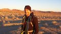
Hash point is about seven km beyond the hills in the background.
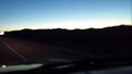
The light available at the time we would have had to hike through the desert.

