Difference between revisions of "2014-01-05 45 -122"
imported>Michael5000 (Created page with "{{subst:Expedition |lat = 45 |lon = -122 |date = 2014-01-05 }}") |
m |
||
| (15 intermediate revisions by 2 users not shown) | |||
| Line 18: | Line 18: | ||
__NOTOC__ | __NOTOC__ | ||
== Location == | == Location == | ||
| − | + | ||
| + | On a wooded, farmed hill in the suburbs of northern Clackamas County. | ||
== Participants == | == Participants == | ||
| − | + | ||
| − | -- | + | * [[User:Michael5000|Michael5000]] -- Expedition #154 |
== Plans == | == Plans == | ||
| − | + | ||
| + | This one seems crazy enough that it just might work. Otherwise, it will be a no trespassing sign for the collection. I'll be approaching from the northwest via Eckhart Lane in the 12:30 to 1:00 time frame. | ||
== Expedition == | == Expedition == | ||
| − | |||
| − | + | I parked in a new suburban neighborhood and headed for the trail entrance that I had seen online. I was glad to see a neighborhood walker head up the path, which seemed to imply that it was a de facto public access area. A narrow path led up to a crude road that led up to a pretty good dirt road around some sort of farm. The final 150 feet required some bushwhacking into the woods. I found the spot, took pictures, and then returned to the truck and went for a run around the neighborhood on a nice, bright sunny January afternoon. | |
| − | |||
== Photos == | == Photos == | ||
| − | + | ||
| − | |||
| − | |||
<gallery perrow="5"> | <gallery perrow="5"> | ||
| + | File:2014-01-06 45 -122 1.JPG|The path up from Eckhart Lane... | ||
| + | File:2014-01-06 45 -122 2.JPG|leads up to a road... | ||
| + | File:2014-01-06 45 -122 3.JPG|that runs along a farm. | ||
| + | File:2014-01-06 45 -122 4.JPG|Me at the hashpoint. | ||
| + | File:2014-01-06 45 -122 5.JPG|The Associate Hashscot. | ||
| + | File:2014-01-06 45 -122 6.JPG|I left my calling card. | ||
</gallery> | </gallery> | ||
== Achievements == | == Achievements == | ||
{{#vardefine:ribbonwidth|800px}} | {{#vardefine:ribbonwidth|800px}} | ||
| − | |||
| − | |||
| − | |||
| − | |||
| − | |||
| − | |||
| − | + | My 100th Expedition to the State of Oregon! | |
| − | |||
| − | |||
| − | |||
| − | |||
[[Category:Expeditions]] | [[Category:Expeditions]] | ||
| − | |||
[[Category:Expeditions with photos]] | [[Category:Expeditions with photos]] | ||
| − | |||
| − | |||
| − | |||
| − | |||
| − | |||
[[Category:Coordinates reached]] | [[Category:Coordinates reached]] | ||
| − | + | {{location|US|OR|CC}} | |
| − | |||
| − | |||
| − | |||
| − | |||
| − | |||
| − | |||
| − | |||
| − | |||
| − | |||
| − | |||
| − | |||
| − | |||
| − | |||
| − | |||
| − | |||
| − | |||
| − | |||
Latest revision as of 13:53, 22 September 2021
| Sun 5 Jan 2014 in 45,-122: 45.4007173, -122.4881152 geohashing.info google osm bing/os kml crox |
Location
On a wooded, farmed hill in the suburbs of northern Clackamas County.
Participants
- Michael5000 -- Expedition #154
Plans
This one seems crazy enough that it just might work. Otherwise, it will be a no trespassing sign for the collection. I'll be approaching from the northwest via Eckhart Lane in the 12:30 to 1:00 time frame.
Expedition
I parked in a new suburban neighborhood and headed for the trail entrance that I had seen online. I was glad to see a neighborhood walker head up the path, which seemed to imply that it was a de facto public access area. A narrow path led up to a crude road that led up to a pretty good dirt road around some sort of farm. The final 150 feet required some bushwhacking into the woods. I found the spot, took pictures, and then returned to the truck and went for a run around the neighborhood on a nice, bright sunny January afternoon.
Photos
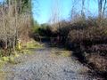
The path up from Eckhart Lane...
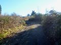
leads up to a road...
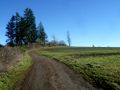
that runs along a farm.

Me at the hashpoint.
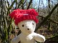
The Associate Hashscot.
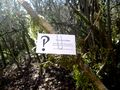
I left my calling card.


Achievements
My 100th Expedition to the State of Oregon!