Difference between revisions of "2014-02-11 53 9"
From Geohashing
imported>Hermann m (corrected categories) |
m |
||
| (One intermediate revision by one other user not shown) | |||
| Line 23: | Line 23: | ||
[[Category:Expeditions with photos]] | [[Category:Expeditions with photos]] | ||
[[Category:Coordinates not reached]] | [[Category:Coordinates not reached]] | ||
| + | [[Category:Not reached - Mother Nature]] | ||
| + | {{location|DE|HH}} | ||
Latest revision as of 18:11, 28 March 2022

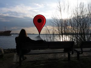
Hermann sitting on a bench, watching the hashpoint. Note: Image might be enhanced for increased viewer experience.
| Tue 11 Feb 2014 in 53,9: 53.5562134, 9.7804640 geohashing.info google osm bing/os kml crox |
Location
Hash is located on the river elbe, right besides the ship channel.
Participants
Hermann biked there with K.
Expedition
Although not reachable without boat, the closest position on the nearest shore is conveniently accessible by bike or foot. Hermann rode his bike to K's place. K wishes to remain anonymous for the time being. Together they cycled to the shore. The small section of shore was recently redesigned in a park-like manner. The hashpoint could be seen from a conveniently placed bank. Photos were taken. Jokes were told. The expedition was otherwise uneventful.
A tracklog exists, but Hermann managed to save it in gpsd native format, which seems to be unreadable for most applications.