Difference between revisions of "2014-03-15 52 5"
From Geohashing
imported>JwB (Created page with "{{subst:Expedition |lat = 52 |lon = 5 |date = 2014-03-15 }}") |
imported>FippeBot m (Location) |
||
| (4 intermediate revisions by 2 users not shown) | |||
| Line 18: | Line 18: | ||
__NOTOC__ | __NOTOC__ | ||
== Location == | == Location == | ||
| − | + | Knarbos west, lelystad | |
== Participants == | == Participants == | ||
| − | + | [[User:JwB|JwB]] ([[User talk:JwB|talk]]) | |
| − | |||
== Plans == | == Plans == | ||
| − | + | see if it was accessible | |
== Expedition == | == Expedition == | ||
| − | + | Got there swiftly, this part of the (planted) forest is accessible, as is the hash. | |
| − | |||
| − | |||
| − | |||
== Photos == | == Photos == | ||
| − | |||
| − | |||
| − | |||
<gallery perrow="5"> | <gallery perrow="5"> | ||
| − | |||
| − | + | Image: 2014-03-15 52 5 hashpoint.jpg | there it is | |
| − | + | Image: 2014-03-15 52 5 grin.jpg | and there i am | |
| − | + | Image: 2014-03-15 52 5 droidscr.png | coordinates: reached | |
| + | Image: 2014-03-15 52 5 proof.png | better accuracy | ||
| + | image: 2014-03-15 52 5 on the way.jpg | shot on the way back, pointing to the hash | ||
| + | </gallery> | ||
| − | |||
| − | |||
| − | |||
| − | |||
| − | |||
| − | |||
| − | |||
| − | |||
| − | |||
| − | |||
| − | |||
| − | |||
[[Category:Expeditions]] | [[Category:Expeditions]] | ||
| − | |||
[[Category:Expeditions with photos]] | [[Category:Expeditions with photos]] | ||
| − | |||
| − | |||
| − | |||
| − | |||
| − | |||
[[Category:Coordinates reached]] | [[Category:Coordinates reached]] | ||
| − | + | {{location|NL|FL}} | |
| − | |||
| − | |||
| − | |||
| − | |||
| − | |||
| − | |||
| − | |||
| − | |||
| − | |||
| − | |||
| − | |||
| − | |||
| − | |||
| − | |||
| − | |||
| − | |||
| − | |||
Latest revision as of 05:54, 14 August 2019
| Sat 15 Mar 2014 in 52,5: 52.4083609, 5.4902828 geohashing.info google osm bing/os kml crox |
Location
Knarbos west, lelystad
Participants
Plans
see if it was accessible
Expedition
Got there swiftly, this part of the (planted) forest is accessible, as is the hash.
Photos
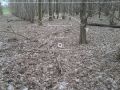
there it is

and there i am

coordinates: reached
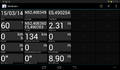
better accuracy
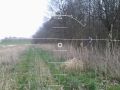
shot on the way back, pointing to the hash


