Difference between revisions of "2014-03-25 52 5"
imported>JwB m (→Participants) |
imported>FippeBot m (Location) |
||
| (6 intermediate revisions by one other user not shown) | |||
| Line 19: | Line 19: | ||
== Location == | == Location == | ||
<!-- where you've surveyed the hash to be --> | <!-- where you've surveyed the hash to be --> | ||
| + | a street between Bussum and Blaricum, next to the A1 motorway | ||
== Participants == | == Participants == | ||
| Line 26: | Line 27: | ||
== Plans == | == Plans == | ||
| − | + | ~10 deviation from commute | |
| − | |||
== Expedition == | == Expedition == | ||
| − | + | did it. parked the car, and went onto the grass, to get to the location. then i realized that i might have as well driven by, and with the tablet in the right part of the car probably would have gotten within accuracy, and claimed a speed racer. On the way back i went through there, but it is not safe to operate a tablet while driving so I have no proof of that. Also the outside thermomenter registered -0.5 C, which might have qualified me for a frozen geohash, but i could not take pictures while driving at the maximum legal speed through the (wider extensions of the region of accuracy) of the hash. | |
| − | + | In retrospect I awarded myself a deja vu, since I lieved near there long time ago, and biked through this place a lot. | |
| − | |||
== Photos == | == Photos == | ||
| − | + | ||
| − | |||
| − | |||
<gallery perrow="5"> | <gallery perrow="5"> | ||
| + | Image:2014-03-25 52 5 cars.jpg | ice still on the parked cars | ||
| + | Image:2014-03-25 52 5 there.jpg | hash is in the grass next to the road | ||
| + | Image:2014-03-25 52 5 droid.png | where I stood | ||
</gallery> | </gallery> | ||
== Achievements == | == Achievements == | ||
| − | {{ | + | {{Radio Yerevan |
| − | + | | achievement = frozen geohash achievement | |
| + | | detail = but it is not safe to take pictures while driving | ||
| + | | date = 2014-03-25 | ||
| + | | latitude = 52 | ||
| + | | longitude = 5 | ||
| + | | user = JwB | ||
| + | }} | ||
| + | {{Déjà vu geohash | ||
| + | | latitude = 52 | ||
| + | | longitude = 5 | ||
| + | | date = 2014-03-25 | ||
| + | | olddate = multiple times between 1986 and 1989 | ||
| + | | name = [[User:JwB|JwB]] | ||
| + | }} | ||
| − | |||
| − | |||
| − | |||
| − | |||
| − | |||
| − | |||
| − | |||
| − | |||
| − | |||
| − | |||
[[Category:Expeditions]] | [[Category:Expeditions]] | ||
| − | |||
[[Category:Expeditions with photos]] | [[Category:Expeditions with photos]] | ||
| − | |||
| − | |||
| − | |||
| − | |||
| − | |||
[[Category:Coordinates reached]] | [[Category:Coordinates reached]] | ||
| − | + | {{location|NL|NH}} | |
| − | |||
| − | |||
| − | |||
| − | |||
| − | |||
| − | |||
| − | |||
| − | |||
| − | |||
| − | |||
| − | |||
| − | |||
| − | |||
| − | |||
| − | |||
| − | |||
| − | |||
Latest revision as of 05:59, 14 August 2019
| Tue 25 Mar 2014 in 52,5: 52.2843263, 5.1850711 geohashing.info google osm bing/os kml crox |
Location
a street between Bussum and Blaricum, next to the A1 motorway
Participants
Plans
~10 deviation from commute
Expedition
did it. parked the car, and went onto the grass, to get to the location. then i realized that i might have as well driven by, and with the tablet in the right part of the car probably would have gotten within accuracy, and claimed a speed racer. On the way back i went through there, but it is not safe to operate a tablet while driving so I have no proof of that. Also the outside thermomenter registered -0.5 C, which might have qualified me for a frozen geohash, but i could not take pictures while driving at the maximum legal speed through the (wider extensions of the region of accuracy) of the hash.
In retrospect I awarded myself a deja vu, since I lieved near there long time ago, and biked through this place a lot.
Photos
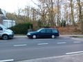
ice still on the parked cars
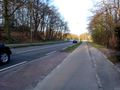
hash is in the grass next to the road
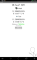
where I stood


Achievements
Is it true that JwB earned the frozen geohash achievement?
|
JwB earned the Déjà Vu Geohash Achievement
|