Difference between revisions of "2014-03-30 47 -122"
imported>Thomcat (An expedition message sent via Geohash Droid for Android.) |
imported>FippeBot m (Location) |
||
| (11 intermediate revisions by 2 users not shown) | |||
| Line 1: | Line 1: | ||
| − | |||
| − | |||
| − | |||
| − | |||
| − | |||
| − | |||
| − | |||
| − | |||
| − | |||
{{meetup graticule | {{meetup graticule | ||
| lat=47 | | lat=47 | ||
| lon=-122 | | lon=-122 | ||
| date=2014-03-30 | | date=2014-03-30 | ||
| + | | graticule_name=Seattle | ||
| + | | graticule_link=Seattle, Washington | ||
}} | }} | ||
| − | |||
__NOTOC__ | __NOTOC__ | ||
== Location == | == Location == | ||
| − | + | On the street in the North Creek technology park | |
== Participants == | == Participants == | ||
| − | + | * [[User:Thomcat|Thomcat]] | |
| − | + | * [[User:OtherJack|OtherJack]] | |
== Plans == | == Plans == | ||
<!-- what were the original plans --> | <!-- what were the original plans --> | ||
| + | Woke up at noon so looks like I missed you Thom! I'll aim for 3 or 4 pm... -- [[User:OtherJack|OtherJack]] ([[User talk:OtherJack|talk]]) 15:47, 30 March 2014 (EDT) | ||
| + | :Should be right about 4pm in fact. -- [[User:OtherJack|OtherJack]] ([[User talk:OtherJack|talk]]) 17:22, 30 March 2014 (EDT) | ||
== Expedition == | == Expedition == | ||
| − | + | === Thomcat === | |
| + | |||
| + | It was my task to be out of the house with two companions from 11:30 to 1:00 - my companions can be unsociable at times. They also like to visit random places and leave their mark. Born geohashers! | ||
| + | |||
| + | Drove to near the spot and parked in the parking lot of Verathon, selecting an appropriate chalk color and visiting the spot itself. I left messages for future geohashers... at least until it rains. | ||
| + | |||
| + | *On the spot -- [[User:Thomcat|Thomcat]] ([[User talk:Thomcat|talk]]) [http://www.openstreetmap.org/?lat=47.77312580&lon=-122.18716315&zoom=16&layers=B000FTF @47.7731,-122.1872] 12:18, 30 March 2014 (PDT) | ||
| − | == | + | We then proceeded around the complex to visit (and smell) more interesting locations. Running through this business park is North Creek, a salmon habitat. Many small dogs were walking with their owners along the trail, which seems pretty interesting overall. By the time I returned to the geohash point, the sun had come out and I snapped one more photo to go. |
| − | + | ||
| + | === OtherJack === | ||
| + | |||
| + | I left my place by bike around 2:20... by this time it was beautiful and sunny out, I was able to comfortably remove my long sleeve shirt for the first time this year. With a nice tailwind I arrived 15 minutes early, at 3:45. On the Burke near Matthews Beach some guy in hardcore cycling gear passed me at about 1.5x my speed belting out "Open Road Song" by Eve6 at the top of his lungs. I think he noticed I was laughing at him... if only he knew about my performance at [[2012-01-28 47 -121]], though that one was only supposed to be for the bears. The final mile or two was on the North Creek Trail, which I'd never ridden before... very interesting route through the UW Bothell campus and then along the creek. Hardwoods were starting their spring leaf-out everywhere. | ||
| + | |||
| + | The hashpoint itself was quite straightforward, in the left-turn lane in the middle of the road according to my GPS. I was able to spend a lot of time trying to get a legible GPS shot, since hardly any cars were driving on this road... Sunday in the office park is pretty dead. It was fairly nice looking for an office park though. Thomcat's chalk marker was clearly visible. | ||
| + | |||
| + | Ride home was not too bad considering the headwind, and I was home before 6 with leftovers awaiting. | ||
== Photos == | == Photos == | ||
| − | |||
| − | |||
| − | |||
<gallery perrow="5"> | <gallery perrow="5"> | ||
| + | Image:2014-03-30_47_-122_Chalking.jpg | ||
| + | Image:2014-03-30_47_-122_Wetlands.jpg | ||
| + | Image:2014-03-30_47_-122_Geohasher.jpg | ||
| + | Image:2014-03-30_47_-122_Companions.jpg | ||
| + | |||
| + | Image:2014-03-30_47_-122_15-57-17-213.jpg | Jack made it! [http://www.openstreetmap.org/?lat=47.77312113&lon=-122.18729120&zoom=16&layers=B000FTF @47.7731,-122.1873] | ||
| + | Image:2014-03-30 15.51.59.jpg | Proof | ||
| + | Image:2014-03-30 15.52.34.jpg | The Mark of Thomcat | ||
| + | Image:2014-03-30 15.52.46.jpg | The spot | ||
| + | Image:2014-03-30 15.52.38.jpg | Officeparkness | ||
| + | Image:2014-03-30 15.59.58.jpg | Vital geohashing equipment | ||
| + | Image:2014-03-30 16.03.16.jpg | Bird & Exotic Animal Medicine | ||
</gallery> | </gallery> | ||
| Line 43: | Line 59: | ||
{{#vardefine:ribbonwidth|800px}} | {{#vardefine:ribbonwidth|800px}} | ||
<!-- Add any achievement ribbons you earned below, or remove this section --> | <!-- Add any achievement ribbons you earned below, or remove this section --> | ||
| + | {{Bicycle geohash | latitude = 47 | longitude = -122 | date = 2014-03-30 | name = [[User:OtherJack|OtherJack]] | distance = about 25km (each way)}} | ||
| − | |||
| − | |||
| − | |||
| − | |||
| − | |||
| − | |||
| − | |||
| − | |||
| − | |||
| − | |||
| − | |||
| − | |||
| − | |||
[[Category:Expeditions]] | [[Category:Expeditions]] | ||
| − | |||
[[Category:Expeditions with photos]] | [[Category:Expeditions with photos]] | ||
| − | |||
| − | |||
| − | |||
| − | |||
| − | |||
[[Category:Coordinates reached]] | [[Category:Coordinates reached]] | ||
| − | + | {{location|US|WA|KN}} | |
| − | |||
| − | |||
| − | |||
| − | |||
| − | |||
| − | |||
| − | |||
| − | |||
| − | |||
| − | |||
| − | |||
| − | |||
| − | |||
| − | |||
| − | |||
| − | |||
| − | |||
Latest revision as of 06:02, 14 August 2019
| Sun 30 Mar 2014 in Seattle: 47.7731213, -122.1871620 geohashing.info google osm bing/os kml crox |
Location
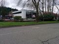
On the street in the North Creek technology park
Participants
Plans
Woke up at noon so looks like I missed you Thom! I'll aim for 3 or 4 pm... -- OtherJack (talk) 15:47, 30 March 2014 (EDT)
Expedition
Thomcat
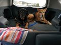
It was my task to be out of the house with two companions from 11:30 to 1:00 - my companions can be unsociable at times. They also like to visit random places and leave their mark. Born geohashers!
Drove to near the spot and parked in the parking lot of Verathon, selecting an appropriate chalk color and visiting the spot itself. I left messages for future geohashers... at least until it rains.
- On the spot -- Thomcat (talk) @47.7731,-122.1872 12:18, 30 March 2014 (PDT)
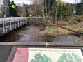
We then proceeded around the complex to visit (and smell) more interesting locations. Running through this business park is North Creek, a salmon habitat. Many small dogs were walking with their owners along the trail, which seems pretty interesting overall. By the time I returned to the geohash point, the sun had come out and I snapped one more photo to go.
OtherJack
I left my place by bike around 2:20... by this time it was beautiful and sunny out, I was able to comfortably remove my long sleeve shirt for the first time this year. With a nice tailwind I arrived 15 minutes early, at 3:45. On the Burke near Matthews Beach some guy in hardcore cycling gear passed me at about 1.5x my speed belting out "Open Road Song" by Eve6 at the top of his lungs. I think he noticed I was laughing at him... if only he knew about my performance at 2012-01-28 47 -121, though that one was only supposed to be for the bears. The final mile or two was on the North Creek Trail, which I'd never ridden before... very interesting route through the UW Bothell campus and then along the creek. Hardwoods were starting their spring leaf-out everywhere.
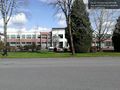
The hashpoint itself was quite straightforward, in the left-turn lane in the middle of the road according to my GPS. I was able to spend a lot of time trying to get a legible GPS shot, since hardly any cars were driving on this road... Sunday in the office park is pretty dead. It was fairly nice looking for an office park though. Thomcat's chalk marker was clearly visible.
Ride home was not too bad considering the headwind, and I was home before 6 with leftovers awaiting.
Photos

Jack made it! @47.7731,-122.1873
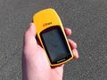
Proof
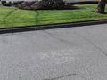
The Mark of Thomcat

The spot
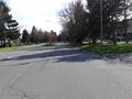
Officeparkness
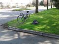
Vital geohashing equipment

Bird & Exotic Animal Medicine


Achievements
OtherJack earned the Bicycle geohash achievement
|