Difference between revisions of "2014-03-31 52 5"
From Geohashing
imported>JwB (Created page with "{{subst:Expedition |lat = 52 |lon = 5 |date = 2014-03-31 }}") |
imported>FippeBot m (Location) |
||
| (5 intermediate revisions by 2 users not shown) | |||
| Line 15: | Line 15: | ||
}} | }} | ||
| − | |||
| − | |||
== Location == | == Location == | ||
| − | + | Korte duinen near Soest | |
== Participants == | == Participants == | ||
| − | + | [[User:JwB|JwB]] ([[User talk:JwB|talk]]) | |
| − | |||
== Plans == | == Plans == | ||
| − | + | Arrive there approx 11h30 AM, and take a stroll around there. | |
== Expedition == | == Expedition == | ||
| − | + | Got near there swiftly, and it turned out that it is a semi-park semi-forest type of walking/strolling area. Followed a path, until 150 m straight south of the coordinates, then went into the undergrowth. 75 meters of struggling got me on anonther path, that passed up to 2 m from the hash. Shot the evidence to attach to the page, and went walking for an hour. Nice day for a hash. | |
| − | |||
| − | |||
| − | |||
== Photos == | == Photos == | ||
| − | |||
| − | |||
| − | |||
<gallery perrow="5"> | <gallery perrow="5"> | ||
| + | Image: 2014-03-31 52 5 droid.png.png | yup | ||
| + | Image: 2014-03-31 52 5 moi.jpg | looking up from the hash | ||
| + | Image: 2014-03-31 52 5 there.jpg | looking down to the hash | ||
</gallery> | </gallery> | ||
== Achievements == | == Achievements == | ||
| − | |||
| − | |||
| − | |||
| − | |||
| − | |||
| − | |||
| − | |||
| − | |||
| − | |||
| − | |||
| − | |||
| − | |||
| − | |||
| − | |||
| − | |||
[[Category:Expeditions]] | [[Category:Expeditions]] | ||
| − | + | [[Category:Expeditions with photos]] | |
| − | [[Category:Expeditions with photos]] | ||
| − | |||
| − | |||
| − | |||
| − | |||
| − | |||
[[Category:Coordinates reached]] | [[Category:Coordinates reached]] | ||
| − | + | {{location|NL|UT}} | |
| − | |||
| − | |||
| − | |||
| − | |||
| − | |||
| − | |||
| − | |||
| − | |||
| − | |||
| − | |||
| − | |||
| − | |||
| − | |||
| − | |||
| − | |||
| − | |||
| − | |||
Latest revision as of 06:04, 14 August 2019
| Mon 31 Mar 2014 in 52,5: 52.1540688, 5.3096559 geohashing.info google osm bing/os kml crox |
Location
Korte duinen near Soest
Participants
Plans
Arrive there approx 11h30 AM, and take a stroll around there.
Expedition
Got near there swiftly, and it turned out that it is a semi-park semi-forest type of walking/strolling area. Followed a path, until 150 m straight south of the coordinates, then went into the undergrowth. 75 meters of struggling got me on anonther path, that passed up to 2 m from the hash. Shot the evidence to attach to the page, and went walking for an hour. Nice day for a hash.
Photos
yup
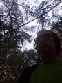
looking up from the hash
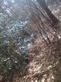
looking down to the hash


