Difference between revisions of "2014-05-05 50 11"
imported>FeepingCreature |
m (Location correction) |
||
| (2 intermediate revisions by 2 users not shown) | |||
| Line 21: | Line 21: | ||
== Participants == | == Participants == | ||
| − | |||
| − | |||
Planning to attend: [[User:FeepingCreature|FeepingCreature]] ([[User talk:FeepingCreature|talk]]) around 17:00 today. | Planning to attend: [[User:FeepingCreature|FeepingCreature]] ([[User talk:FeepingCreature|talk]]) around 17:00 today. | ||
== Plans == | == Plans == | ||
Gonna try and head up with my bike. 14km is lucky. | Gonna try and head up with my bike. 14km is lucky. | ||
| − | |||
== Expedition == | == Expedition == | ||
Success. Details later. Need to buy fluids. | Success. Details later. Need to buy fluids. | ||
| − | |||
| − | + | Okay. Update. There was a lot more hill between me and the target than I anticipated. Also, 3km on foot feel a lot longer than 3km on bike. Total tour length: 39km! | |
| − | + | ||
| + | Visited the Riechheimer Berg on the way. Restaurant had already closed, but they had bottles of drinks outside with a bowl and a sign saying "Pay on trust." Mighty decent of them. | ||
| + | |||
| + | Also, on the way back there was a glorious downhill ride where I did not need to touch the pedals for six continuous minutes. (I timed it.) The view was great as well. | ||
== Photos == | == Photos == | ||
| − | |||
| − | |||
| − | |||
<gallery perrow="5"> | <gallery perrow="5"> | ||
| + | Image:2014-05-05-17_38_19_50_11_proof_of_hash.png | Had to trample a bit of wheat to get there. | ||
| + | Image:2014-05-05-17_38_19_50_11_photo_of_the_target.jpg | Not much though. I was careful. | ||
| + | Image:2014-05-05-17_38_19_50_11_photo_of_me.jpg | Hi! | ||
</gallery> | </gallery> | ||
== Achievements == | == Achievements == | ||
{{#vardefine:ribbonwidth|800px}} | {{#vardefine:ribbonwidth|800px}} | ||
| − | |||
| − | |||
| − | |||
| − | |||
| − | |||
| − | |||
| − | |||
| − | |||
| − | |||
| − | |||
| − | |||
| − | |||
| − | |||
| − | |||
| − | |||
[[Category:Expeditions]] | [[Category:Expeditions]] | ||
| − | |||
[[Category:Expeditions with photos]] | [[Category:Expeditions with photos]] | ||
| − | |||
| − | |||
| − | |||
| − | |||
| − | |||
[[Category:Coordinates reached]] | [[Category:Coordinates reached]] | ||
| − | + | {{location|DE|TH|IK}} | |
| − | |||
| − | |||
| − | |||
| − | |||
| − | |||
| − | |||
| − | |||
| − | |||
| − | |||
| − | |||
| − | |||
| − | |||
| − | |||
| − | |||
| − | |||
| − | |||
| − | |||
Latest revision as of 20:23, 16 May 2020
| Mon 5 May 2014 in 50,11: 50.8950721, 11.1306958 geohashing.info google osm bing/os kml crox |
Location
Participants
Planning to attend: FeepingCreature (talk) around 17:00 today.
Plans
Gonna try and head up with my bike. 14km is lucky.
Expedition
Success. Details later. Need to buy fluids.
Okay. Update. There was a lot more hill between me and the target than I anticipated. Also, 3km on foot feel a lot longer than 3km on bike. Total tour length: 39km!
Visited the Riechheimer Berg on the way. Restaurant had already closed, but they had bottles of drinks outside with a bowl and a sign saying "Pay on trust." Mighty decent of them.
Also, on the way back there was a glorious downhill ride where I did not need to touch the pedals for six continuous minutes. (I timed it.) The view was great as well.
Photos
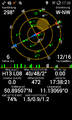
Had to trample a bit of wheat to get there.
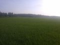
Not much though. I was careful.
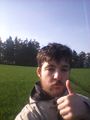
Hi!


