Difference between revisions of "2014-05-19 -43 173"
imported>Quaternary (→Achievements) |
m (per Renaming Proposal) |
||
| (5 intermediate revisions by 2 users not shown) | |||
| Line 49: | Line 49: | ||
<gallery> | <gallery> | ||
Image:2014_05_19_-43_173_Geolocation1.PNG | The Le Bons Bay graticule is about 3% land. | Image:2014_05_19_-43_173_Geolocation1.PNG | The Le Bons Bay graticule is about 3% land. | ||
| − | Image:2014_05_19_-43_173_Geolocation2.PNG | So finding a geohash near | + | Image:2014_05_19_-43_173_Geolocation2.PNG | So finding a geohash near Le Bons Bay itself was awesome. |
Image:2014_05_19_-43_173_Geolocation3.PNG | The geohash was about 10 metres off the road. | Image:2014_05_19_-43_173_Geolocation3.PNG | The geohash was about 10 metres off the road. | ||
</gallery> | </gallery> | ||
| − | |||
| − | |||
== Photos == | == Photos == | ||
| Line 63: | Line 61: | ||
Image:2014_05_19_-43_173_04_Summit Road.JPG | Close-up of the yachts in a sheltered bay. | Image:2014_05_19_-43_173_04_Summit Road.JPG | Close-up of the yachts in a sheltered bay. | ||
Image:2014_05_19_-43_173_05_Summit Road.JPG | Cattle wander amongst the stumps of the (burnt) trees of forests that once covered these hills. | Image:2014_05_19_-43_173_05_Summit Road.JPG | Cattle wander amongst the stumps of the (burnt) trees of forests that once covered these hills. | ||
| − | Image:2014_05_19_-43_173_06_Summit Road.JPG | View at two o'clock. | + | Image:2014_05_19_-43_173_06_Summit Road.JPG | View at two o'clock. It's about now that we are crossing the threshold into the -43, 173 graticule. |
Image:2014_05_19_-43_173_07_Summit Road.JPG | We see several of these volcanic 'pegs' as we drive around the Summit Road. | Image:2014_05_19_-43_173_07_Summit Road.JPG | We see several of these volcanic 'pegs' as we drive around the Summit Road. | ||
Image:2014_05_19_-43_173_08_Summit Road.JPG | Finally the turn off to Le Bons Bay! | Image:2014_05_19_-43_173_08_Summit Road.JPG | Finally the turn off to Le Bons Bay! | ||
| Line 76: | Line 74: | ||
== Achievements == | == Achievements == | ||
| − | {{ | + | {{Graticule unlocked |
| latitude = -43 | | latitude = -43 | ||
| Line 93: | Line 91: | ||
| name = Quaternary | | name = Quaternary | ||
| + | }} | ||
| + | |||
| + | {{Minesweeper geohash | ||
| + | | graticule = Christchurch,_New_Zealand | ||
| + | | ranknumber = 2 | ||
| + | | e = true | ||
| + | | w = true | ||
| + | | name = Quaternary | ||
}} | }} | ||
| Line 98: | Line 104: | ||
[[Category:Expeditions with photos]] | [[Category:Expeditions with photos]] | ||
[[Category:Coordinates reached]] | [[Category:Coordinates reached]] | ||
| + | {{location|NZ|CAN}} | ||
Latest revision as of 05:12, 20 March 2024

| Mon 19 May 2014 in -43,173: -43.7691033, 173.0209358 geohashing.info google osm bing/os kml crox |
Location
Le Bons Bay, Canterbury, New Zealand
Participants
The Quaternary (talk) family geohashers
Plans
The Le Bons Bay graticule is a largely sea based region, with about 3% of the area being actual land. Other than a small parcel of land at the top left corner, most of this land is towards the bottom left, being the Eastern tip of Banks Peninsula.
So when a geohash came up in the valley of Le Bons Bay itself (which lends its name to this very graticule), I thought that this had to be a priority for the day!
First of all, getting permission to get access to the land, so the night before I managed to track down the owner - many thanks to John for giving me permission to access the geohash location! (John, if you are ever in Christchurch, please look me up and I'll buy you a coffee!)
Expedition
The day was sunny and mild - a lovely autumn day to be out and about geohashing.
To access the geohash, one option is to take the extremely scenic Summit Road, which strangely enough, winds around the lip of the volcanic cone. This volcano erupted about 12 million years ago, and has weathered to the lovely peninsula we have today. The volcanic plug, also known as the Onawe Peninsula, is prominent in most of the harbour views. (It was the site of a Ngai Tahu pa captured by Te Rauparaha, chief of the Ngati Toa in 1831. Up to 1,200 people were killed here.)
Le Bons Bay Road comes off Summit Road, and the geohash was about 10 metres off the road a little from the turn-off.
When we parked the car, we got a glorious blast in the ear from the resident Bellbird.
The geohash is just on the interface between a paddock and a native forest remnant. So I tucked the geohash marker just under a young Totara tree. May you still be looking down on the ocean in the centuries to come.
Tracklog
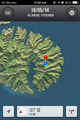
The Le Bons Bay graticule is about 3% land.
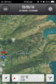
So finding a geohash near Le Bons Bay itself was awesome.
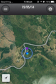
The geohash was about 10 metres off the road.


Photos
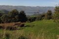
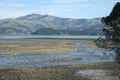
The view from the start of the Summit Road. To get to Le Bons Bay Road, we will be driving in a large semi-cirle. With the Onawe Peninsula at the middle of the dial, here is the view from the nine o'clock position.
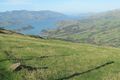
Here at ten o'clock we get a good view of the harbour entrance.
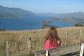
Stopping at twelve o'clock we take in the views from a handily positioned seat.

Close-up of the yachts in a sheltered bay.
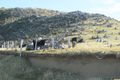
Cattle wander amongst the stumps of the (burnt) trees of forests that once covered these hills.
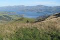
View at two o'clock. It's about now that we are crossing the threshold into the -43, 173 graticule.
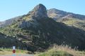
We see several of these volcanic 'pegs' as we drive around the Summit Road.
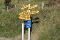
Finally the turn off to Le Bons Bay!
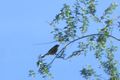
The Bellbird.
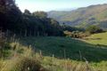
The location of the geohash! (The hashpoint is about in the centre of the photo, at the edge of the forest).
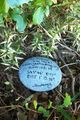
The hashpoint is marked.
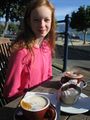
Celebrating with latte, hot chocolate and muffin, Akaora.
Taking the 'low road' back to Christchurch, we say a final farewell to the Onawe Peninsula, this time at sea level.
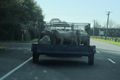
Racing back to work to get to a 2pm meeting, some sheep slow down progress.


Achievements
Quaternary earned the Graticule Unlocked Achievement
|
Quaternary earned the Ambassador achievement
|
Quaternary achieved level 2 of the Minesweeper Geohash achievement
|