Difference between revisions of "2014-06-03 45 -122"
From Geohashing
imported>Michael5000 (Created page with "{{subst:Expedition |lat = 45 |lon = -122 |date = 2014-06-03 }}") |
imported>FippeBot m (Location) |
||
| (5 intermediate revisions by one other user not shown) | |||
| Line 18: | Line 18: | ||
__NOTOC__ | __NOTOC__ | ||
== Location == | == Location == | ||
| − | + | ||
| + | In a large vacant lot along SE 1st Street in Gresham. | ||
== Participants == | == Participants == | ||
| − | |||
| − | |||
| − | + | * [[User:Michael5000|Michael5000]] | |
| − | |||
== Expedition == | == Expedition == | ||
| − | |||
| − | + | I overshot work on the drive in, and parked a few blocks from the point. The field is lushly overgrown after a wet spring, and there is plenty of chin-high grass. Instead of heading directly in from 1st Street, I took the fire lane in to the oddly disembodied cul-de-sac that will someday connect to the street that will someday hook through the vacant lot. From there, it was a matter of walking past the end of the sidewalk and through 50 meters or so of tall grass. Some blackberries are starting to come up right where the hashpoint is, which will make it inaccessible by the end of the summer if they aren't cut back. But by then, it won't be a hashpoint. | |
| − | + | ||
== Photos == | == Photos == | ||
| Line 38: | Line 35: | ||
--> | --> | ||
<gallery perrow="5"> | <gallery perrow="5"> | ||
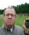
| + | File:2014-06-03 45 -122 (2).JPG|Me, at hashpoint | ||
| + | File:2014-06-03 45 -122 (4).JPG|View from hashpoint, camera held up a bit | ||
| + | File:2014-06-03 45 -122 (3).JPG|View from hashpoint, camera held at eye level | ||
</gallery> | </gallery> | ||
| Line 45: | Line 45: | ||
| − | |||
| − | |||
| − | |||
| − | |||
| − | |||
| − | |||
| − | |||
| − | |||
| − | |||
| − | |||
[[Category:Expeditions]] | [[Category:Expeditions]] | ||
| − | |||
[[Category:Expeditions with photos]] | [[Category:Expeditions with photos]] | ||
| − | |||
| − | |||
| − | |||
| − | |||
| − | |||
[[Category:Coordinates reached]] | [[Category:Coordinates reached]] | ||
| − | + | <!-- or if you failed :( | |
| − | |||
[[Category:Coordinates not reached]] | [[Category:Coordinates not reached]] | ||
-- and a reason -- | -- and a reason -- | ||
| Line 84: | Line 67: | ||
(Don't forget to delete this final close comment marker) --> | (Don't forget to delete this final close comment marker) --> | ||
| + | {{location|US|OR|MU}} | ||
Latest revision as of 06:47, 14 August 2019
| Tue 3 Jun 2014 in 45,-122: 45.4968638, -122.4011509 geohashing.info google osm bing/os kml crox |
Location
In a large vacant lot along SE 1st Street in Gresham.
Participants
Expedition
I overshot work on the drive in, and parked a few blocks from the point. The field is lushly overgrown after a wet spring, and there is plenty of chin-high grass. Instead of heading directly in from 1st Street, I took the fire lane in to the oddly disembodied cul-de-sac that will someday connect to the street that will someday hook through the vacant lot. From there, it was a matter of walking past the end of the sidewalk and through 50 meters or so of tall grass. Some blackberries are starting to come up right where the hashpoint is, which will make it inaccessible by the end of the summer if they aren't cut back. But by then, it won't be a hashpoint.


