Difference between revisions of "2014-08-02 60 26"
From Geohashing
imported>Bysmyyr (Created page with "{{subst:Expedition |lat = 60 |lon = 26 |date = 2014-08-02 }}") |
m (per Renaming Proposal) |
||
| (10 intermediate revisions by 5 users not shown) | |||
| Line 23: | Line 23: | ||
<!-- who attended: If you link to your wiki user name in this section, your expedition will be picked up by the various statistics generated for geohashing. You may use three tildes ~ as a shortcut to automatically insert the user signature of the account you are editing with. | <!-- who attended: If you link to your wiki user name in this section, your expedition will be picked up by the various statistics generated for geohashing. You may use three tildes ~ as a shortcut to automatically insert the user signature of the account you are editing with. | ||
--> | --> | ||
| + | [[User:Bysmyyr|Bysmyyr]] ([[User talk:Bysmyyr|talk]]) | ||
| + | My girlfriend | ||
== Plans == | == Plans == | ||
<!-- what were the original plans --> | <!-- what were the original plans --> | ||
| Line 29: | Line 31: | ||
== Expedition == | == Expedition == | ||
<!-- how it all turned out. your narrative goes here. --> | <!-- how it all turned out. your narrative goes here. --> | ||
| + | |||
| + | The final hash! 10/10! We were a little bit tired and sun was going down so we had to go home. It was nice trip, hope you like to read it, or at least look the pictures :P | ||
== Tracklog == | == Tracklog == | ||
<!-- if your GPS device keeps a log, you may post a link here --> | <!-- if your GPS device keeps a log, you may post a link here --> | ||
| + | |||
| + | See [[2014-08-02_59_24 | starting hash...]] | ||
| + | {{tracklog|2014-08-02 Bysmyyr Tracklog.gpx}} | ||
== Photos == | == Photos == | ||
| Line 38: | Line 45: | ||
--> | --> | ||
<gallery perrow="5"> | <gallery perrow="5"> | ||
| + | Image:2014-08-02_21-03-54.jpg | Dam near last hash | ||
| + | Image:2014-08-02_21-06-51.jpg | Proof | ||
| + | Image:2014-08-02 21-07-09.jpg | The Hash | ||
| + | Image:2014-08-02_21-07-37.jpg | Getting dark | ||
| + | Image:2014-08-02_21-50-40.jpg | Me, the plane and the Stupid Grin | ||
</gallery> | </gallery> | ||
| Line 44: | Line 56: | ||
<!-- Add any achievement ribbons you earned below, or remove this section --> | <!-- Add any achievement ribbons you earned below, or remove this section --> | ||
| + | {{Graticule unlocked | ||
| + | | latitude = 60 | ||
| + | | longitude = 26 | ||
| + | | date = 2014-08-02 | ||
| + | | name = Bysmyyr | ||
| + | | image = 2014-08-02_21-50-40.jpg | ||
| + | }} | ||
| + | |||
| + | {{air geohash | latitude = 60 | longitude = 26 | date = 2014-08-02 | name = Bysmyyr | vehicle = Ultralight plane | subcategory = Pilot }} | ||
<!-- =============== USEFUL CATEGORIES FOLLOW ================ | <!-- =============== USEFUL CATEGORIES FOLLOW ================ | ||
Delete the next line ONLY if you have chosen the appropriate categories below. If you are unsure, don't worry. People will read your report and help you with the classification.--> | Delete the next line ONLY if you have chosen the appropriate categories below. If you are unsure, don't worry. People will read your report and help you with the classification.--> | ||
| − | + | ||
<!-- ==REQUEST FOR TWITTER BOT== Please leave either the New report or the Expedition planning category in as long as you work on it. This helps the twitter bot a lot with announcing the right outcome at the right moment. --> | <!-- ==REQUEST FOR TWITTER BOT== Please leave either the New report or the Expedition planning category in as long as you work on it. This helps the twitter bot a lot with announcing the right outcome at the right moment. --> | ||
| Line 56: | Line 77: | ||
--> | --> | ||
| − | |||
[[Category:Expeditions]] | [[Category:Expeditions]] | ||
| − | + | ||
[[Category:Expeditions with photos]] | [[Category:Expeditions with photos]] | ||
| − | + | ||
| − | |||
| − | |||
| − | |||
| − | |||
[[Category:Coordinates reached]] | [[Category:Coordinates reached]] | ||
| − | + | {{location|FI|16}} | |
| − | |||
| − | |||
| − | |||
| − | |||
| − | |||
| − | |||
| − | |||
| − | |||
| − | |||
| − | |||
| − | |||
| − | |||
| − | |||
| − | |||
| − | |||
| − | |||
| − | |||
Latest revision as of 05:10, 20 March 2024
| Sat 2 Aug 2014 in 60,26: 60.9228439, 26.4103215 geohashing.info google osm bing/os kml crox |
Location
Participants
My girlfriend
Plans
Expedition
The final hash! 10/10! We were a little bit tired and sun was going down so we had to go home. It was nice trip, hope you like to read it, or at least look the pictures :P
Tracklog
See starting hash...
Photos
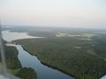
Dam near last hash
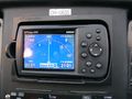
Proof
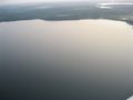
The Hash
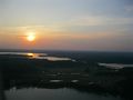
Getting dark
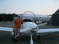
Me, the plane and the Stupid Grin


Achievements
Bysmyyr earned the Graticule Unlocked Achievement
|
Bysmyyr earned the Air geohash achievement
|