Difference between revisions of "2014-08-08 48 -4"
imported>JwB m (→Achievements) |
m (per Renaming Proposal) |
||
| (4 intermediate revisions by 3 users not shown) | |||
| Line 18: | Line 18: | ||
__NOTOC__ | __NOTOC__ | ||
== Location == | == Location == | ||
| − | just a few meters of the GR34, the long distance walking path along the entire French west coast. | + | Douarnenez, just a few meters of the GR34, the long distance walking path along the entire French west coast. |
== Participants == | == Participants == | ||
| Line 33: | Line 33: | ||
== Photos == | == Photos == | ||
| − | + | ||
| − | |||
| − | |||
<gallery perrow="5"> | <gallery perrow="5"> | ||
| + | Image:2014-08-08 48 -4 screen.png| coordinates | ||
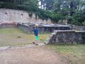
| + | Image:2014-08-08 48 -4 ruins.jpg| | ||
| + | Image:2014-08-08 48 -4 bassins.jpg| the tubs where they kept the fish that was caught | ||
| + | Image:2014-08-08 48 -4 bay view.jpg| view along the bay | ||
</gallery> | </gallery> | ||
== Achievements == | == Achievements == | ||
| − | {{ | + | {{Graticule unlocked |
| latitude = 48 | | latitude = 48 | ||
| longitude = -4 | | longitude = -4 | ||
| − | | date = | + | | date = 2014-08-08 |
| name = JwB and 3 dragalongs | | name = JwB and 3 dragalongs | ||
}} | }} | ||
| − | + | ||
[[Category:Expeditions]] | [[Category:Expeditions]] | ||
[[Category:Expeditions with photos]] | [[Category:Expeditions with photos]] | ||
[[Category:Coordinates reached]] | [[Category:Coordinates reached]] | ||
| + | {{location|FR|29}} | ||
Latest revision as of 05:10, 20 March 2024
| Fri 8 Aug 2014 in 48,-4: 48.0901767, -4.3112848 geohashing.info google osm bing/os kml crox |
Location
Douarnenez, just a few meters of the GR34, the long distance walking path along the entire French west coast.
Participants
Plans
On our way to the Douarnenez market, to get some last things prior to the trip home. Amongst which the best take-away crepes of Brittany in the creperie des halles. As the hash is near the main road into town, stop nearby, and walk 200 m to the hash.
Expedition
The way to the path also gave acces to the ruins of a 1st-4th century AD roman "Garum" factory. This is a fermented salty fish sauce, which was in use throughout the Roman empire. In the 12th century new factories were placed on top, which are ruins now also.
From that point to the hash it was only 90 meters along the long distance walking path. Underneath the trees GPS accuracy dropped, and I only once saw a green flash in the droid-app, but was too late to capture the screenshot. The kids wanted to continue our journey to the creperie in the market halles, so we went on.
Photos
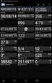
coordinates
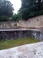
the tubs where they kept the fish that was caught
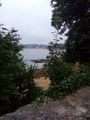
view along the bay


Achievements
JwB and 3 dragalongs earned the Graticule Unlocked Achievement
|