Difference between revisions of "2014-10-27 49 8"
imported>DODO (→Achievements) |
m (Location correction) |
||
| (5 intermediate revisions by 3 users not shown) | |||
| Line 1: | Line 1: | ||
| − | |||
| − | |||
| − | |||
| − | |||
| − | |||
| − | |||
| − | |||
| − | |||
| − | |||
| − | |||
{{meetup graticule | {{meetup graticule | ||
| lat=49 | | lat=49 | ||
| Line 36: | Line 26: | ||
== Tracklog == | == Tracklog == | ||
<!-- if your GPS device keeps a log, you may post a link here --> | <!-- if your GPS device keeps a log, you may post a link here --> | ||
| − | + | [http://www.gpsies.com/map.do?fileId=zyofoubkpcnwbjmp bull: 3,1 KM (should have walked)] | |
== Photos == | == Photos == | ||
| Line 43: | Line 33: | ||
--> | --> | ||
<gallery perrow="5"> | <gallery perrow="5"> | ||
| + | Image:2014-10-27_49_8-1.jpg | 70m in that direction, near the border between the brown and the muddy green field | ||
| + | Image:2014-10-27_49_8-2.jpg | view towards the farm. Nobody is in this tractor, but I found another place to buy my asparagus | ||
| + | Image:2014-10-27_49_8-3.jpg | happy hasher | ||
| + | Image:2014-10-27_49_8-4.jpg | quick proof | ||
| + | Image:2014-10-27_49_8-5.jpg | view from the hash. This tractor is driving | ||
</gallery> | </gallery> | ||
| − | |||
== Achievements == | == Achievements == | ||
| Line 57: | Line 51: | ||
| − | |||
| − | |||
[[Category:Expeditions]] | [[Category:Expeditions]] | ||
[[Category:Expeditions with photos]] | [[Category:Expeditions with photos]] | ||
[[Category:Coordinates reached]] | [[Category:Coordinates reached]] | ||
| + | {{location|DE|RP|RP}} | ||
Latest revision as of 20:26, 16 May 2020
| Mon 27 Oct 2014 in 49,8: 49.3066542, 8.3927019 geohashing.info google osm bing/os kml crox |
Location
On a rhubarb field next to a farm south of Dudenhofen
Participants
Plans
Swing by before work.
Expedition
I had hardly any time but the hashpoint was so close to home that I couldn't leave it out with a clear conscience. So, when I saddled my bull to ride to work I just took the 3 KM detour there, staked the bull and walked the remaining 70 m through the muddy field. Just when I reached the hashpoint, a tractor left the farm next to the field and three men are looking at me. I took a quick photo of them and walked back to my bike. The tractor just drove on to the next field and ignored me. Then I continued to work. A fast and easy success.
Tracklog
bull: 3,1 KM (should have walked)
Photos
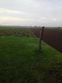
70m in that direction, near the border between the brown and the muddy green field
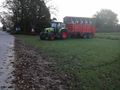
view towards the farm. Nobody is in this tractor, but I found another place to buy my asparagus

happy hasher
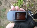
quick proof
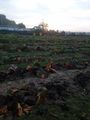
view from the hash. This tractor is driving


Achievements
DODO earned the Land geohash achievement
|