Difference between revisions of "2014-11-26 49 8"
imported>Q-Owl (Created page with " Smile|thumb|left {{meetup graticule | lat=49 | lon=8 | date=2014-11-26 }}__NOTOC__ == Location == Near [http://de.wikipedia.org/wiki/Au...") |
imported>FippeBot m (Location) |
||
| (7 intermediate revisions by one other user not shown) | |||
| Line 1: | Line 1: | ||
| − | [[Image:2014-11- | + | [[Image:2014-11-16 49 8 ne.jpg | view to NE in the morning|thumb|left |
| − | | lat=49 | + | ]] {{meetup graticule |
| − | | lon=8 | + | | lat=49 |
| − | | date=2014-11-26 | + | | lon=8 |
| − | }}__NOTOC__ | + | | date=2014-11-26 }}__NOTOC__ |
| − | |||
== Location == | == Location == | ||
| − | + | In [http://de.wikipedia.org/wiki/Auerbach_%28Bensheim%29 Bensheim-Auerbach] near a voltage transformation substation and about 200 m west of ALDI. | |
| − | |||
== Participants == | == Participants == | ||
| Line 15: | Line 13: | ||
== Plan == | == Plan == | ||
| − | + | Surprise in early morning: Todays hashpoint is less then 1 km from home and about 80 m next to the route I drive to work.^^ | |
| − | + | <br>So I planned to drive by car near the hash area, walk to the hashpoint, take some photos, return to the car and drive to work. | |
| − | |||
| − | |||
| + | Nearest geocache: [http://coord.info/GC46HY5 GC46HY5] about 450 m as a deer runs / 500 m walk. | ||
== Expedition == | == Expedition == | ||
| − | I reached the | + | I reached the hashpoint area at 07:35. The hashpoint is situated in an old little orchard under an elder busch which grows next to the remains of an old apple tree. |
| − | + | The estate south to the orchard is a voltage transformation substation. | |
| − | |||
| − | |||
| − | |||
| − | |||
| − | |||
| − | I took a | + | I took some photos, marked the hashpoint with a big green leaf, smiled and drove to work. |
| − | |||
| − | |||
== Photos == | == Photos == | ||
| − | |||
| − | |||
<gallery perrow="5" > | <gallery perrow="5" > | ||
| − | Image:2014-11- | + | Image:2014-11-16 49 8 sc.png | proof |
| − | + | Image:2014-11-16 49 8 mark.jpg | hashpoint marked with big green leaf | |
| − | Image:2014-11- | + | Image:2014-11-16 49 8 ne.jpg | view to NE in the morning |
| − | Image:2014-11- | + | Image:2014-11-16 49 8 nw.jpg | view to NW |
| − | Image:2014-11- | + | Image:2014-11-16 49 8 s.jpg | view to SE: transformation substation |
| − | Image:2014-11- | + | Image:2014-11-16 49 8 grin.jpg | smile |
| − | + | </gallery> | |
| − | Image:2014-11- | + | The photos have wrong names (2014-11-16 ...). Sorry. But I visited the hp on 2014-11-26. |
| − | |||
| − | |||
<!-- | <!-- | ||
List of uploaded Files: | List of uploaded Files: | ||
| Line 65: | Line 51: | ||
| name = [[User:Q-Owl|Q-Owl]] | | name = [[User:Q-Owl|Q-Owl]] | ||
}} | }} | ||
| + | |||
| + | |||
| + | Honorable Mention: | ||
| + | * Since the invention of geohashing the nearest hashpoint to our home (according to the [[Implementations/Online#Shotgun|Shotgun]] retro mapping tool) | ||
<!-- | <!-- | ||
{{Meet-up | {{Meet-up | ||
| Line 73: | Line 63: | ||
| other = [[User:Nnnnnnn|Nnnnnnn]] | | other = [[User:Nnnnnnn|Nnnnnnn]] | ||
}} --> | }} --> | ||
| − | |||
<!-- =============== USEFUL CATEGORIES FOLLOW ================ --> | <!-- =============== USEFUL CATEGORIES FOLLOW ================ --> | ||
| Line 91: | Line 80: | ||
[[Category: Meetup on 2014-11-08]] | [[Category: Meetup on 2014-11-08]] | ||
[[Category: Meetup in 49 8]] --> | [[Category: Meetup in 49 8]] --> | ||
| + | {{location|DE|HE|HP}} | ||
Latest revision as of 02:04, 15 August 2019

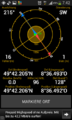
| Wed 26 Nov 2014 in 49,8: 49.7034316, 8.6082276 geohashing.info google osm bing/os kml crox |
Location
In Bensheim-Auerbach near a voltage transformation substation and about 200 m west of ALDI.
Participants
Plan
Surprise in early morning: Todays hashpoint is less then 1 km from home and about 80 m next to the route I drive to work.^^
So I planned to drive by car near the hash area, walk to the hashpoint, take some photos, return to the car and drive to work.
Nearest geocache: GC46HY5 about 450 m as a deer runs / 500 m walk.
Expedition
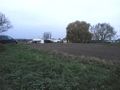
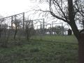
I reached the hashpoint area at 07:35. The hashpoint is situated in an old little orchard under an elder busch which grows next to the remains of an old apple tree. The estate south to the orchard is a voltage transformation substation.
I took some photos, marked the hashpoint with a big green leaf, smiled and drove to work.
Photos
proof
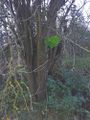
hashpoint marked with big green leaf
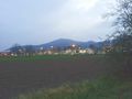
view to NE in the morning
view to NW
view to SE: transformation substation
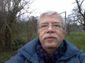
smile


The photos have wrong names (2014-11-16 ...). Sorry. But I visited the hp on 2014-11-26.
Achievements / Honorable Mention
Q-Owl earned the Land geohash achievement
|
Honorable Mention:
- Since the invention of geohashing the nearest hashpoint to our home (according to the Shotgun retro mapping tool)