Difference between revisions of "2015-01-11 45 -75"
From Geohashing
imported>Jlam ([live picture] Other side of Moodie drive from the geohash. These kinds of desolate landscapes just faacinate me. [http://www.openstreetmap.org/?lat=45.21950000&lon=-75.77330000&zoom=16&layers=B000FTF @45.2195,-75.7733]) |
m (More specific location) |
||
| (5 intermediate revisions by 3 users not shown) | |||
| Line 19: | Line 19: | ||
== Location == | == Location == | ||
<!-- where you've surveyed the hash to be --> | <!-- where you've surveyed the hash to be --> | ||
| + | |||
| + | Moodie Dr, possibly on Lafarge property. | ||
== Participants == | == Participants == | ||
<!-- who attended: If you link to your wiki user name in this section, your expedition will be picked up by the various statistics generated for geohashing. You may use three tildes ~ as a shortcut to automatically insert the user signature of the account you are editing with. | <!-- who attended: If you link to your wiki user name in this section, your expedition will be picked up by the various statistics generated for geohashing. You may use three tildes ~ as a shortcut to automatically insert the user signature of the account you are editing with. | ||
--> | --> | ||
| + | |||
| + | [[User:Jlam|Jlam]] ([[User talk:Jlam|talk]]) 18:14, 11 January 2015 (EST) | ||
== Plans == | == Plans == | ||
| Line 29: | Line 33: | ||
== Expedition == | == Expedition == | ||
<!-- how it all turned out. your narrative goes here. --> | <!-- how it all turned out. your narrative goes here. --> | ||
| + | |||
| + | My first geohash!!! | ||
| + | |||
| + | After getting a spare part at Ikea, used the VrtuCar to go to Moodie Dr. Stopped at the McEwen where a smart guy told me everything about fuel and Ethanol blend. Road shoulder was really slipery as I stopped near the geohash. Had a winter boots I could have gotten closer. | ||
== Tracklog == | == Tracklog == | ||
| Line 47: | Line 55: | ||
{{#vardefine:ribbonwidth|800px}} | {{#vardefine:ribbonwidth|800px}} | ||
<!-- Add any achievement ribbons you earned below, or remove this section --> | <!-- Add any achievement ribbons you earned below, or remove this section --> | ||
| + | {{My kingdom for a boat | ||
| + | | latitude = 45 | longitude = -75 | date = 2015-01-11 | name = [[User:Jlam|Jlam]] | waterhazard = snowfield of indeterminate depth | image = 2015-01-11_45_-75_jlam_1421003043917.jpg | ||
| + | }} | ||
| − | |||
| − | |||
| − | |||
| − | |||
| − | |||
| − | |||
| − | |||
| − | |||
| − | |||
| − | |||
| − | |||
[[Category:Expeditions]] | [[Category:Expeditions]] | ||
| − | |||
[[Category:Expeditions with photos]] | [[Category:Expeditions with photos]] | ||
| − | |||
| − | |||
| − | |||
| − | |||
| − | |||
| − | |||
| − | |||
| − | |||
| − | |||
[[Category:Coordinates not reached]] | [[Category:Coordinates not reached]] | ||
| − | |||
| − | |||
[[Category:Not reached - Mother Nature]] | [[Category:Not reached - Mother Nature]] | ||
| − | + | {{location|CA|ON|OT}} | |
| − | |||
| − | |||
| − | |||
| − | |||
| − | |||
| − | |||
| − | |||
| − | |||
| − | |||
| − | |||
Latest revision as of 00:09, 10 August 2020
| Sun 11 Jan 2015 in 45,-75: 45.2192347, -75.7727021 geohashing.info google osm bing/os kml crox |
Location
Moodie Dr, possibly on Lafarge property.
Participants
Jlam (talk) 18:14, 11 January 2015 (EST)
Plans
Expedition
My first geohash!!!
After getting a spare part at Ikea, used the VrtuCar to go to Moodie Dr. Stopped at the McEwen where a smart guy told me everything about fuel and Ethanol blend. Road shoulder was really slipery as I stopped near the geohash. Had a winter boots I could have gotten closer.
Tracklog
Photos
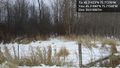
About as close as I'll get to the geohash without winter boots or jumping that fence. @45.2189,-75.7733
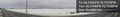
Other side of Moodie drive from the geohash. These kinds of desolate landscapes just faacinate me. @45.2195,-75.7733

Achievements
Jlam earned the My kingdom for a boat consolation prize
|