Difference between revisions of "2015-02-21 52 1"
From Geohashing
imported>Sourcerer (→Planning) |
imported>FippeBot m (Location) |
||
| (8 intermediate revisions by one other user not shown) | |||
| Line 3: | Line 3: | ||
| lon=1 | | lon=1 | ||
| date=2015-02-21 | | date=2015-02-21 | ||
| + | | graticule_name=Norwich, UK | ||
| + | | graticule_link=Norwich, United Kingdom | ||
}} | }} | ||
__NOTOC__ | __NOTOC__ | ||
| Line 16: | Line 18: | ||
Planning two hashpoints spanning midnight: [[2015-02-21 52 1]] :: [[2015-02-22 52 1]] | Planning two hashpoints spanning midnight: [[2015-02-21 52 1]] :: [[2015-02-22 52 1]] | ||
| + | |||
| + | *Arrived. -- [[User:Sourcerer|Sourcerer]] ([[User talk:Sourcerer|talk]]) [http://www.openstreetmap.org/?lat=52.22191751&lon=1.24490440&zoom=16&layers=B000FTF @52.2219,1.2449] 22:07, 21 February 2015 (GMT) | ||
| + | |||
| + | There was a grass frost with rather wet ground underneath. The sky was clear, starry and very dark. The waxing moon had set hours ago. The hashpoint was in a field with plenty of clay in the soil, judging by the build-up of mud on my footwear. | ||
== Photos == | == Photos == | ||
<gallery perrow="5"> | <gallery perrow="5"> | ||
| + | Image:2015-02-21_52_1_Sourcerer_1424556379484.jpg | Proof [http://www.openstreetmap.org/?lat=52.22190142&lon=1.24496877&zoom=16&layers=B000FTF @52.2219,1.2450] | ||
| + | Image:2015-02-21 52 1 Sourcerer 2.jpg | Track Log | ||
</gallery> | </gallery> | ||
| Line 25: | Line 33: | ||
{{#vardefine:ribbonwidth|800px}} | {{#vardefine:ribbonwidth|800px}} | ||
| − | + | {{Sourcerer_links | |
| − | {{ | + | | prev = 2015-02-20 52 0 |
| − | | | + | | curr = 2015-02-21 52 1 |
| − | | | + | | next = 2015-02-22 52 1 |
| − | | | + | | date = 2015-02-21 |
| − | | date = 2015-02- | ||
| − | |||
}} | }} | ||
| − | |||
| − | |||
| − | |||
| − | |||
| − | |||
| − | |||
| − | |||
| − | |||
[[Category:Expeditions]] | [[Category:Expeditions]] | ||
[[Category:Expeditions with photos]] | [[Category:Expeditions with photos]] | ||
[[Category:Coordinates reached]] | [[Category:Coordinates reached]] | ||
| − | + | {{location|GB|ENG|SFK}} | |
Latest revision as of 02:48, 15 August 2019
| Sat 21 Feb 2015 in Norwich, UK: 52.2219379, 1.2449723 geohashing.info google osm bing/os kml crox |
Location
In a field close to a footpath between Ashfield and Earl Soham, Suffolk, UK.
Participants
Expedition
Planning two hashpoints spanning midnight: 2015-02-21 52 1 :: 2015-02-22 52 1
- Arrived. -- Sourcerer (talk) @52.2219,1.2449 22:07, 21 February 2015 (GMT)
There was a grass frost with rather wet ground underneath. The sky was clear, starry and very dark. The waxing moon had set hours ago. The hashpoint was in a field with plenty of clay in the soil, judging by the build-up of mud on my footwear.
Photos
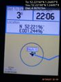
Proof @52.2219,1.2450
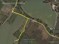
Track Log


Achievements
Expeditions and Plans
| 2015-02-21 | ||
|---|---|---|
| München, Germany | TheOneRing | only 162m apart that one of 2014-06-09 near Maisach. Perfect for Déjà Vu Geohash. |
| Pforzheim, Germany | RecentlyChanged | We drove near the Hashpoint, from where we walked the few hundred meters. I... |
| Norwich, United Kingdom | Sourcerer | In a field close to a footpath between Ashfield and Earl Soham, Suffolk, UK... |
Sourcerer's Expedition Links
2015-02-20 52 0 - 2015-02-21 52 1 - 2015-02-22 52 1 - KML file download of Sourcerer's expeditions for use with Google Earth.