Difference between revisions of "2015-02-21 48 8"
From Geohashing
imported>RecentlyChanged ([live] My sisters asked for something to do, I've instantly got an idea! Now on our way.) |
m |
||
| (5 intermediate revisions by 3 users not shown) | |||
| Line 1: | Line 1: | ||
| − | + | ||
| + | <!-- If you did not specify these parameters in the template, please substitute appropriate values for IMAGE, LAT, LON, and DATE (YYYY-MM-DD format) | ||
| + | |||
| + | [[Image:{{{image|IMAGE}}}|thumb|left]] | ||
| + | |||
| + | Remove this section if you don't want an image at the top (left) of your report. You should remove the "Image:" or "File:" | ||
| + | tag from your image file name, and replace the all upper-case word IMAGE in the above line. | ||
| + | |||
| + | And DON'T FORGET to add your expedition and the best photo you took to the gallery on the Main Page! We'd love to read your report, but that means we first have to discover it! :) | ||
| + | --> | ||
| + | {{meetup graticule | ||
| + | | lat=48 | ||
| + | | lon=8 | ||
| + | | date=2015-02-21 | ||
| + | }} | ||
| + | |||
| + | |||
| + | |||
| + | == Participants == | ||
| + | [[User:RecentlyChanged|RecentlyChanged]] ([[User_talk:RecentlyChanged|talk]]), my sisters and Freeeeef | ||
| + | |||
| + | == Plans == | ||
*My sisters asked for something to do, I've instantly got an idea! Now on our way. -- [[User:RecentlyChanged|RecentlyChanged]] ([[User_talk:RecentlyChanged|talk]]) 16:14, 21 February 2015 (CET) | *My sisters asked for something to do, I've instantly got an idea! Now on our way. -- [[User:RecentlyChanged|RecentlyChanged]] ([[User_talk:RecentlyChanged|talk]]) 16:14, 21 February 2015 (CET) | ||
| + | |||
| + | There wasn't much of a plan, except we thought it would be cold and with a lot of snow, so we took our sleds with us. | ||
| + | |||
| + | == Expedition == | ||
| + | We drove near the Hashpoint, from where we walked the few hundred meters. It wasn't a really hard geohash, but it was fun, because it was warm and the landscape was nice, we had quite a nice view through the trees. | ||
| + | |||
| + | == Tracklog == | ||
| + | http://www.everytrail.com/view_trip.php?trip_id=3098126 | ||
| + | |||
| + | == Photos == | ||
| + | <!-- Insert pictures between the gallery tags using the following format: | ||
| + | Image:2012-##-## ## ## Alpha.jpg | Witty Comment | ||
| + | --> | ||
| + | <gallery perrow="5"> | ||
| + | |||
| + | Image:2015-02-21_48_8_RecentlyChanged_1424535497000.jpg | All the grinning people! [http://www.openstreetmap.org/?lat=48.22209477&lon=8.24508905&zoom=16&layers=B000FTF @48.2221,8.2451] | ||
| + | </gallery> | ||
| + | |||
| + | == Achievements == | ||
| + | {{#vardefine:ribbonwidth|800px}} | ||
| + | |||
| + | {{Two to the N achievement | ||
| + | | count = 1 | ||
| + | | date = 2015-02-21 | ||
| + | | latitude = 48 | ||
| + | | longitude = 8 | ||
| + | | name = RCs older sis | ||
| + | | reached = true | ||
| + | }} | ||
| + | |||
| + | [[Category:Expeditions]] | ||
| + | [[Category:Coordinates reached]] | ||
| + | [[Category:Expeditions with photos]] | ||
| + | {{location|DE|BW|OG}} | ||
Latest revision as of 09:21, 12 September 2021
| Sat 21 Feb 2015 in 48,8: 48.2219379, 8.2449723 geohashing.info google osm bing/os kml crox |
Participants
RecentlyChanged (talk), my sisters and Freeeeef
Plans
- My sisters asked for something to do, I've instantly got an idea! Now on our way. -- RecentlyChanged (talk) 16:14, 21 February 2015 (CET)
There wasn't much of a plan, except we thought it would be cold and with a lot of snow, so we took our sleds with us.
Expedition
We drove near the Hashpoint, from where we walked the few hundred meters. It wasn't a really hard geohash, but it was fun, because it was warm and the landscape was nice, we had quite a nice view through the trees.
Tracklog
http://www.everytrail.com/view_trip.php?trip_id=3098126
Photos
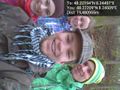
All the grinning people! @48.2221,8.2451

Achievements
RCs older sis earned the Two to the N achievement
|