Difference between revisions of "2015-02-25 52 1"
From Geohashing
imported>Sourcerer m ([retro picture] Proof. [http://www.openstreetmap.org/?lat=52.38871336&lon=1.41254783&zoom=16&layers=B000FTF @52.3887,1.4125]) |
imported>FippeBot m (Location) |
||
| (4 intermediate revisions by one other user not shown) | |||
| Line 3: | Line 3: | ||
| lon=1 | | lon=1 | ||
| date=2015-02-25 | | date=2015-02-25 | ||
| + | | graticule_name=Norwich, UK | ||
| + | | graticule_link=Norwich, United Kingdom | ||
}} | }} | ||
__NOTOC__ | __NOTOC__ | ||
| Line 15: | Line 17: | ||
== Expedition == | == Expedition == | ||
| − | Planning two hashpoints spanning midnight: [[2015-02-24 52 0]] :: [[2015-02-25 52 1]] | + | Planning two hashpoints and a retro-hash spanning midnight: [[2015-02-24 52 0]] :: [[2015-01-22 52 1 | Retro]] :: [[2015-02-25 52 1]] |
| + | *Arrived. -- [[User:Sourcerer|Sourcerer]] ([[User talk:Sourcerer|talk]]) [http://www.openstreetmap.org/?lat=52.38871336&lon=1.41254783&zoom=16&layers=B000FTF @52.3887,1.4125] 00:01, 25 February 2015 (GMT) | ||
| + | This was a re-run of my [[2015-01-22 52 1]] expedition with the small addition of the new hashpoint 80 metres from the previous one. | ||
| − | |||
== Photos == | == Photos == | ||
<gallery perrow="5"> | <gallery perrow="5"> | ||
| − | |||
Image:2015-02-25_52_1_Sourcerer_1424822391695.jpg | Proof. [http://www.openstreetmap.org/?lat=52.38871336&lon=1.41254783&zoom=16&layers=B000FTF @52.3887,1.4125] | Image:2015-02-25_52_1_Sourcerer_1424822391695.jpg | Proof. [http://www.openstreetmap.org/?lat=52.38871336&lon=1.41254783&zoom=16&layers=B000FTF @52.3887,1.4125] | ||
| + | Image:2015-02-25 52 1 Sourcerer 2.jpg | Track Log | ||
</gallery> | </gallery> | ||
| − | |||
| − | |||
== Achievements == | == Achievements == | ||
{{#vardefine:ribbonwidth|800px}} | {{#vardefine:ribbonwidth|800px}} | ||
| Line 45: | Line 46: | ||
| name = Sourcerer | | name = Sourcerer | ||
}} | }} | ||
| − | |||
| − | |||
| − | {{ | + | {{Sourcerer_links |
| − | + | | prev = 2015-02-24 52 0 | |
| − | + | | curr = 2015-02-25 52 1 | |
| + | | next = 2015-02-26 52 1 | ||
| + | | date = 2015-02-25 | ||
| + | }} | ||
| − | |||
[[Category:Expeditions]] | [[Category:Expeditions]] | ||
[[Category:Expeditions with photos]] | [[Category:Expeditions with photos]] | ||
[[Category:Coordinates reached]] | [[Category:Coordinates reached]] | ||
| − | + | {{location|GB|ENG|SFK}} | |
Latest revision as of 02:51, 15 August 2019
| Wed 25 Feb 2015 in Norwich, UK: 52.3887025, 1.4125312 geohashing.info google osm bing/os kml crox |
Location
In a field really close to 2015-01-22 52 1 between Ilketshall Saint Margaret and Saint James South Elmham, Suffolk, UK.
Participants
Expedition
Planning two hashpoints and a retro-hash spanning midnight: 2015-02-24 52 0 :: Retro :: 2015-02-25 52 1
- Arrived. -- Sourcerer (talk) @52.3887,1.4125 00:01, 25 February 2015 (GMT)
This was a re-run of my 2015-01-22 52 1 expedition with the small addition of the new hashpoint 80 metres from the previous one.
Photos

Proof. @52.3887,1.4125
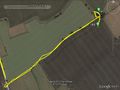
Track Log


Achievements
Sourcerer earned the Consecutive geohash achievement
|
Sourcerer earned the Midnight Geohash achievement
|
Expeditions and Plans
| 2015-02-25 | ||
|---|---|---|
| Bologna, Italy | lucaPost | Right on the ridge between Zena valley and Idice valley |
| Mannheim, Germany | DODO | On the edge of the same field between Schifferstadt and Waldsee as the 2015... |
| Kassel, Germany | GeorgDerReisende | The hash lay on a meadow of the Schloss Wilhelmsthal between Kassel and Cal... |
| Norwich, United Kingdom | Sourcerer | In a field really close to 2015-01-22 52 1 between Ilketshall Saint Margaret and Saint Jam... |
| Hannover, Germany | Fippe | located in a forest near Haste. |
Sourcerer's Expedition Links
2015-02-24 52 0 - 2015-02-25 52 1 - 2015-02-26 52 1 - KML file download of Sourcerer's expeditions for use with Google Earth.