Difference between revisions of "2015-03-25 52 9"
From Geohashing
imported>GeorgDerReisende (new expedition) |
m (Linking to The Dance™) |
||
| (7 intermediate revisions by 2 users not shown) | |||
| Line 1: | Line 1: | ||
| − | |||
| − | |||
| − | |||
| − | |||
| − | |||
| − | |||
| − | |||
| − | |||
| − | |||
| − | |||
{{meetup graticule | {{meetup graticule | ||
| lat=52 | | lat=52 | ||
| Line 18: | Line 8: | ||
__NOTOC__ | __NOTOC__ | ||
== Location == | == Location == | ||
| − | + | ||
| + | The hash lies in the forest west of Fuhrberg. | ||
== Participants == | == Participants == | ||
| − | + | ||
| − | + | [[User:GeorgDerReisende|GeorgDerReisende]] | |
== Plans == | == Plans == | ||
| − | + | ||
| + | I will hitchhike to the junction Mellendorf on the A7 and walk to the hash. I will be there at about 11:45. I can make it a little bit later, if I get a note on this page before 6:30! | ||
| + | |||
| + | I was too late last night, so I am starting at 9 o'clock and arriving at about 14:00. | ||
== Expedition == | == Expedition == | ||
| − | + | ||
| + | I left home at 10 o'clock. I waited for one hour for the first lift. With two cars I arrived at the junction Mellendorf on the A7. Then I walked to the hash. After a short dance in the thicket I found the hash on a stack of dung. | ||
== Tracklog == | == Tracklog == | ||
| Line 38: | Line 33: | ||
--> | --> | ||
<gallery perrow="5"> | <gallery perrow="5"> | ||
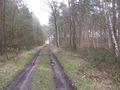
| + | Image:2015-03-25 52 9 GeorgDerReisende 3368.jpg | the way to the hash | ||
| + | Image:2015-03-25 52 9 GeorgDerReisende 3374.jpg | arrived | ||
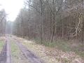
| + | Image:2015-03-25 52 9 GeorgDerReisende 3375.jpg | the west | ||
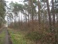
| + | Image:2015-03-25 52 9 GeorgDerReisende 3376.jpg | the east | ||
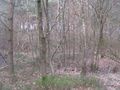
| + | Image:2015-03-25 52 9 GeorgDerReisende 3377.jpg | the north | ||
| + | Image:2015-03-25 52 9 GeorgDerReisende 3378.jpg | the south and the hash | ||
| + | Image:2015-03-25 52 9 GeorgDerReisende 3379.jpg | [[The Dance™|the dance]] | ||
| + | Image:2015-03-25 52 9 GeorgDerReisende 3380.jpg | the geohasher | ||
</gallery> | </gallery> | ||
| Line 44: | Line 47: | ||
<!-- Add any achievement ribbons you earned below, or remove this section --> | <!-- Add any achievement ribbons you earned below, or remove this section --> | ||
| + | {{Thumbs Up | latitude = 52 | longitude = 9 | date = 2015-03-25 | name = GeorgDerReisende }} | ||
| − | + | {{Last man standing | latitude = 52 | longitude = 9 | date = 2015-03-25 | name = GeorgDerReisende }} | |
| − | |||
| − | |||
| − | + | [[Category:Expeditions]] | |
| − | + | [[Category:Expeditions with photos]] | |
| − | |||
| − | [[Category: | ||
| − | |||
| − | |||
| − | |||
| − | |||
| − | |||
| − | |||
| − | |||
| − | |||
| − | |||
| − | |||
[[Category:Coordinates reached]] | [[Category:Coordinates reached]] | ||
| − | + | {{location|DE|NI|H}} | |
| − | |||
| − | |||
| − | |||
| − | |||
| − | |||
| − | |||
| − | |||
| − | |||
| − | |||
| − | |||
| − | |||
| − | |||
| − | |||
| − | |||
| − | |||
| − | |||
| − | |||
Latest revision as of 17:02, 14 November 2020
| Wed 25 Mar 2015 in 52,9: 52.5697747, 9.8230793 geohashing.info google osm bing/os kml crox |
Location
The hash lies in the forest west of Fuhrberg.
Participants
Plans
I will hitchhike to the junction Mellendorf on the A7 and walk to the hash. I will be there at about 11:45. I can make it a little bit later, if I get a note on this page before 6:30!
I was too late last night, so I am starting at 9 o'clock and arriving at about 14:00.
Expedition
I left home at 10 o'clock. I waited for one hour for the first lift. With two cars I arrived at the junction Mellendorf on the A7. Then I walked to the hash. After a short dance in the thicket I found the hash on a stack of dung.
Tracklog
Photos
the way to the hash

arrived
the west
the east
the north
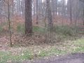
the south and the hash
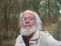
the geohasher


Achievements
GeorgDerReisende earned the Thumbs Up Geohash Achievement
|
GeorgDerReisende earned the Last man standing achievement
|