Difference between revisions of "2015-05-08 49 8"
imported>Q-Owl (Created page with "<!--thumb|left|Grin² --> {{meetup graticule | lat=49 | lon=8 | date=2015-05-08 }}__NOTOC__ == Location == Near Leutershausen on the w...") |
imported>FippeBot m (Location) |
||
| (10 intermediate revisions by one other user not shown) | |||
| Line 1: | Line 1: | ||
| − | <!--[[Image:2015- | + | <!--[[Image:2015-05-08 49 8 grin.jpg|thumb|left|Grin² ]] --> |
{{meetup graticule | {{meetup graticule | ||
| lat=49 | | lat=49 | ||
| Line 7: | Line 7: | ||
== Location == | == Location == | ||
| − | Near Leutershausen on the western rim of the [[wikipedia:Odenwald|Odenwald]] | + | Near Leutershausen on the western rim of the [[wikipedia:Odenwald|Odenwald]], not very far from my earthcache [http://coord.info/GC54684 GC54684]. :-) |
| + | |||
| + | More information: [[wikipedia:Hirschberg_an_der_Bergstraße|Hirschberg]] (en), [http://de.wikipedia.org/wiki/Hirschberg_an_der_Bergstraße Hirschberg] (de) | ||
== Participants == | == Participants == | ||
| Line 15: | Line 17: | ||
== Plan == | == Plan == | ||
| − | Drive by car from Heidelberg to Leutershausen and walk up the hashpoint. | + | Drive by car from Heidelberg to Leutershausen and walk up to the hashpoint. Try to find some geocaches. Return to Heidelberg. |
== Expedition == | == Expedition == | ||
| − | + | It happened according to plan: I drove to Leutershausen, found a mystery geocache ([http://coord.info/GC27W2B GC27W2B]) on the way up to the hash and a normal cache on the way back to the car. | |
| − | + | ||
| + | The hash was located a 16 m below the path on a rather steep slope, which meant 10 minutes of strenuous hash dance. | ||
| + | But at 8:00 pm I succeded with a 0 m screenshot on my smartphone. After that I took some photos and walked back to the car. :-) | ||
== Photos == | == Photos == | ||
<!-- Insert pictures between the gallery tags using the following format: | <!-- Insert pictures between the gallery tags using the following format: | ||
Image:2014-##-## ## ## Alpha.jpg | Witty Comment | Image:2014-##-## ## ## Alpha.jpg | Witty Comment | ||
| − | --> | + | --> |
| − | |||
<gallery perrow="5" > | <gallery perrow="5" > | ||
| − | Image:2015- | + | Image:2015-05-08 49 8 walk.jpg | Walk to the hashpoint and view SE. The hp is 16 m to the right of the bush in the rear. |
| − | Image:2015- | + | Image:2015-05-08 49 8 proof.png | Proof |
| − | Image:2015- | + | Image:2015-05-08 49 8 mark.jpg | The big stump marks the hashpoint |
| − | Image:2015- | + | Image:2015-05-08 49 8 north.jpg | At the hp: View north |
| − | Image:2015- | + | Image:2015-05-08 49 8 east.jpg | View east |
| − | Image:2015- | + | Image:2015-05-08 49 8 south.jpg | View south |
| − | Image:2015- | + | Image:2015-05-08 49 8 west.jpg | View west |
| + | Image:2015-05-08 49 8 grin.jpg | Happy Grin | ||
</gallery> | </gallery> | ||
| − | + | ||
<!-- | <!-- | ||
List of uploaded Files: | List of uploaded Files: | ||
| Line 84: | Line 88: | ||
[[Category:Expeditions with photos]] | [[Category:Expeditions with photos]] | ||
| − | [[Category: Meetup on 2015-05- | + | [[Category: Meetup on 2015-05-08]] |
[[Category: Meetup in 49 8]] | [[Category: Meetup in 49 8]] | ||
| + | {{location|DE|BW|HD}} | ||
Latest revision as of 03:34, 15 August 2019
| Fri 8 May 2015 in 49,8: 49.4928954, 8.6785815 geohashing.info google osm bing/os kml crox |
Location
Near Leutershausen on the western rim of the Odenwald, not very far from my earthcache GC54684. :-)
More information: Hirschberg (en), Hirschberg (de)
Participants
Plan
Drive by car from Heidelberg to Leutershausen and walk up to the hashpoint. Try to find some geocaches. Return to Heidelberg.
Expedition
It happened according to plan: I drove to Leutershausen, found a mystery geocache (GC27W2B) on the way up to the hash and a normal cache on the way back to the car.
The hash was located a 16 m below the path on a rather steep slope, which meant 10 minutes of strenuous hash dance. But at 8:00 pm I succeded with a 0 m screenshot on my smartphone. After that I took some photos and walked back to the car. :-)
Photos
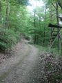
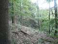
Walk to the hashpoint and view SE. The hp is 16 m to the right of the bush in the rear.
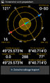
Proof
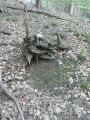
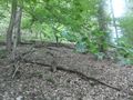
The big stump marks the hashpoint
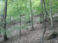
At the hp: View north
View east
View south
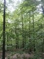
View west

Happy Grin


Achievements / Honorable Mention
Q-Owl earned the Land geohash achievement
|
Other Geohashing Expeditions and Plans on This Day
Expeditions and Plans
| 2015-05-08 | ||
|---|---|---|
| Mannheim, Germany | Q-Owl | Near Leutershausen on the western rim of the Odenwald, not very far from m... |
| Norwich, United Kingdom | Sourcerer | In a grazing field on the marshes north east of the Waveney River Centre, N... |
| Hannover, Germany | GeorgDerReisende, Fippe | lies in the forest of Kananohe. |
| Manchester, United Kingdom | Marsh, Marsh's fiancee | located on Garswood Road, one of the more major roads within the village of... |