Difference between revisions of "2015-06-03 49 8"
imported>RecentlyChanged (Another picture of the drowned rat.) |
imported>FippeBot m (Location) |
||
| (12 intermediate revisions by 3 users not shown) | |||
| Line 15: | Line 15: | ||
}} | }} | ||
| − | + | ||
__NOTOC__ | __NOTOC__ | ||
== Location == | == Location == | ||
| − | + | A quarry pond. | |
== Participants == | == Participants == | ||
| − | |||
| − | |||
| − | + | * [[User:RecentlyChanged|RecentlyChanged]] | |
| − | |||
== Expedition == | == Expedition == | ||
| − | + | After I've told DODO that I will try these I had a reason to go. | |
| + | But the real credit for this expedition goes to Pedalpusher, who gave the last shove with his [[multihash|2015-06-03_43_-78]] he is doing today. | ||
| + | |||
| + | So I finally picked myself up and left the house at around 7pm. | ||
| + | |||
| + | From there I had a really nice, but not really interesting, tour to the hash. | ||
| + | |||
| + | Only worth noticing is probably that I chose the route planning to go back along the Rhine and make a tron out of it. | ||
| + | |||
| + | Reaching the pond I was immediately attacked by small flying raptors. | ||
| + | But I did not falter due to such unimportant things. | ||
| + | I was in reach of the hash! (I recently learned about the [[Stupidity distance]]. SD in this case: around 100meters. [[User:RecentlyChanged|RecentlyChanged]] ([[User_talk:RecentlyChanged|talk]]) 12:20, 27 November 2015 (EST)) | ||
| + | |||
| + | I started to walk around the pond, ignoring the naked old man (in hindsight, he's probably eaten by now). | ||
| + | On my way I met a fisherman with his young daughter, whom I asked if I can swim to the hashpoint. | ||
| + | He told me nicely that on the other site there would be sun, but said it wasn't a problem after I told him I'm doing a safari geocache. | ||
| + | The word geocache did it for him and I went on. | ||
| + | |||
| + | A few metres further on a little gangplank where to more fishermen, almost at my starting point. | ||
| + | I asked them too, if it would be okay and they too told me that on the other side it would be way better. | ||
| + | I told them what I was up to, but I of course did not push the matter. | ||
| + | The raptors already were trying to drive me crazy so I would have lived with not reaching the hashpoint. | ||
| + | But after they heard I just had to reach some coordinates they told me not to dive. | ||
| + | They went on talking about what crazy things are out there in the world and I answered them that this crazy thing had gotten me out of my room, doing nothing. | ||
| + | |||
| + | They countered I wouldn't be eaten there, which would be better. | ||
| + | We parted laughing. | ||
| + | |||
| + | I walked to the next gangplank far enough from the fishermen, they told me their fishing rods will be out about 20 metres. | ||
| + | At the gangplank I quickly changed into my bathers and swam out about what I thought are 100 metres. | ||
| + | |||
| + | Sadly I can't prove or check the exact position where I stopped, but I think I was out far enough. | ||
| + | I then went back, decided against changing again because of the raptors and went back home. | ||
| + | |||
| + | If you follow my tracklog you can see where I messed up the tron achievement, that's also the spot where I finally changed. | ||
| + | I was home about three hours later, happy! | ||
== Tracklog == | == Tracklog == | ||
| − | + | http://www.everytrail.com/view_trip.php?trip_id=3245627 | |
== Photos == | == Photos == | ||
| − | + | ||
| − | + | ||
| − | |||
<gallery perrow="5"> | <gallery perrow="5"> | ||
| − | + | Image:2015-06-03_49_8_RecentlyChanged_1433352832000.jpg | I made this on the way to the hash. It was nice on the way! | |
| + | Image:2015-06-03_49_8_RecentlyChanged_1433353384000.jpg | The rules with map | ||
| + | Image:2015-06-03_49_8_RecentlyChanged_1433353380000.jpg | The map of the lake. I'm usually not allowed to go to the hash. But I asked! | ||
| + | Image:2015-06-03_49_8_RecentlyChanged_1433353585000.jpg | There will be a sand beach soon | ||
Image:2015-06-03_49_8_RecentlyChanged_1433354380000.jpg | Happy hasher! | Image:2015-06-03_49_8_RecentlyChanged_1433354380000.jpg | Happy hasher! | ||
| − | + | Image:2015-06-03_49_8_RecentlyChanged_1433360411000.jpg | Yeah, I took that in the bath at home. But the message is important! (Rough translation: It wasn't intelligent, but Awesome!) | |
| − | Image:2015-06- | ||
</gallery> | </gallery> | ||
== Achievements == | == Achievements == | ||
{{#vardefine:ribbonwidth|800px}} | {{#vardefine:ribbonwidth|800px}} | ||
| − | + | {{water geohash | |
| + | | latitude = 49 | ||
| + | | longitude = 8 | ||
| + | | date = 2015-06-03 | ||
| + | | name = [[User:RecentlyChanged|RecentlyChanged]] | ||
| − | + | }} | |
| − | + | {{bicycle geohash | |
| − | [[ | + | | latitude = 49 |
| + | | longitude = 8 | ||
| + | | date = 2015-06-03 | ||
| + | | name = [[User:RecentlyChanged|RecentlyChanged]] | ||
| + | | distance = 42.5km | ||
| + | | bothways = true | ||
| − | + | }} | |
| + | {{Geoflashing | ||
| + | | latitude = 49 | ||
| + | | longitude = 8 | ||
| + | | date = 2015-06-03 | ||
| + | | name = [[User:RecentlyChanged|RecentlyChanged]] | ||
| + | | excuse = to go swimming | ||
| − | + | }} | |
| − | + | {{Velociraptor geohash | |
| − | [[ | + | | latitude = 49 |
| − | + | | longitude = 8 | |
| + | | date = 2015-06-03 | ||
| + | | name = [[User:RecentlyChanged|RecentlyChanged]] | ||
| + | }} | ||
| − | |||
[[Category:Expeditions]] | [[Category:Expeditions]] | ||
| − | |||
[[Category:Expeditions with photos]] | [[Category:Expeditions with photos]] | ||
| − | |||
| − | |||
| − | |||
| − | |||
| − | |||
[[Category:Coordinates reached]] | [[Category:Coordinates reached]] | ||
| − | + | {{location|DE|BW|KA}} | |
| − | |||
| − | |||
| − | |||
| − | |||
| − | |||
| − | |||
| − | |||
| − | |||
| − | |||
| − | |||
| − | |||
| − | |||
| − | |||
| − | |||
| − | |||
| − | |||
| − | |||
Latest revision as of 03:53, 15 August 2019
| Wed 3 Jun 2015 in 49,8: 49.1525477, 8.3884927 geohashing.info google osm bing/os kml crox |
Location
A quarry pond.
Participants
Expedition
After I've told DODO that I will try these I had a reason to go. But the real credit for this expedition goes to Pedalpusher, who gave the last shove with his 2015-06-03_43_-78 he is doing today.
So I finally picked myself up and left the house at around 7pm.
From there I had a really nice, but not really interesting, tour to the hash.
Only worth noticing is probably that I chose the route planning to go back along the Rhine and make a tron out of it.
Reaching the pond I was immediately attacked by small flying raptors. But I did not falter due to such unimportant things. I was in reach of the hash! (I recently learned about the Stupidity distance. SD in this case: around 100meters. RecentlyChanged (talk) 12:20, 27 November 2015 (EST))
I started to walk around the pond, ignoring the naked old man (in hindsight, he's probably eaten by now). On my way I met a fisherman with his young daughter, whom I asked if I can swim to the hashpoint. He told me nicely that on the other site there would be sun, but said it wasn't a problem after I told him I'm doing a safari geocache. The word geocache did it for him and I went on.
A few metres further on a little gangplank where to more fishermen, almost at my starting point. I asked them too, if it would be okay and they too told me that on the other side it would be way better. I told them what I was up to, but I of course did not push the matter. The raptors already were trying to drive me crazy so I would have lived with not reaching the hashpoint. But after they heard I just had to reach some coordinates they told me not to dive. They went on talking about what crazy things are out there in the world and I answered them that this crazy thing had gotten me out of my room, doing nothing.
They countered I wouldn't be eaten there, which would be better. We parted laughing.
I walked to the next gangplank far enough from the fishermen, they told me their fishing rods will be out about 20 metres. At the gangplank I quickly changed into my bathers and swam out about what I thought are 100 metres.
Sadly I can't prove or check the exact position where I stopped, but I think I was out far enough. I then went back, decided against changing again because of the raptors and went back home.
If you follow my tracklog you can see where I messed up the tron achievement, that's also the spot where I finally changed. I was home about three hours later, happy!
Tracklog
http://www.everytrail.com/view_trip.php?trip_id=3245627
Photos
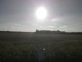
I made this on the way to the hash. It was nice on the way!
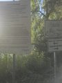
The rules with map
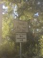
The map of the lake. I'm usually not allowed to go to the hash. But I asked!
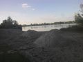
There will be a sand beach soon

Happy hasher!

Yeah, I took that in the bath at home. But the message is important! (Rough translation: It wasn't intelligent, but Awesome!)


Achievements
RecentlyChanged earned the Water geohash achievement
|
RecentlyChanged earned the Bicycle geohash achievement
|
RecentlyChanged earned the Geoflashing Achievement
|
RecentlyChanged earned the Velociraptor Geohash Achievement
|