Difference between revisions of "2015-09-13 52 0"
imported>Sourcerer m ([live] Arrived) |
imported>FippeBot m (Location) |
||
| (5 intermediate revisions by one other user not shown) | |||
| Line 3: | Line 3: | ||
| lon=0 | | lon=0 | ||
| date=2015-09-13 | | date=2015-09-13 | ||
| + | | graticule_name=Cambridge, UK | ||
| + | | graticule_link=Cambridge, United Kingdom | ||
}} | }} | ||
__NOTOC__ | __NOTOC__ | ||
| − | |||
== Location == | == Location == | ||
| Line 20: | Line 21: | ||
== Expedition == | == Expedition == | ||
| + | *Arrived -- [[User:Sourcerer|Sourcerer]] ([[User talk:Sourcerer|talk]]) [http://www.openstreetmap.org/?lat=52.14808166&lon=.96289158&zoom=16&layers=B000FTF @52.1481,.9629] 00:03, 13 September 2015 (GMT+01:00) | ||
| + | According to the Google Earth satellite view, I had reached the point. On the ground, the point appeared to be over the fence. a few metres into the next property. As I was making crunching noises in the gravel at midnight, I didn't try to hash-dance any closer. On a [[2013-07-15 52 1|similar expedition]], Google showed the hashpoint on the wrong side of the fence so I didn't claim that one. Today Google falls in my favour so I'll claim this one. Anyone doing a "no-batteries" would claim this without a second thought. | ||
| − | |||
| − | |||
== Photos == | == Photos == | ||
<gallery perrow="5"> | <gallery perrow="5"> | ||
| − | |||
Image:2015-09-13_52_0_Sourcerer_1442098930052.jpg | Proof. [http://www.openstreetmap.org/?lat=52.14836061&lon=.96277356&zoom=16&layers=B000FTF @52.1484,.9628] | Image:2015-09-13_52_0_Sourcerer_1442098930052.jpg | Proof. [http://www.openstreetmap.org/?lat=52.14836061&lon=.96277356&zoom=16&layers=B000FTF @52.1484,.9628] | ||
| + | Image:2015-09-13_52_0_Sourcerer.jpg | Track in Google Earth | ||
</gallery> | </gallery> | ||
| Line 39: | Line 40: | ||
| date = 2015-09-13 | | date = 2015-09-13 | ||
| OSMlink = 33959831 | | OSMlink = 33959831 | ||
| + | | name = Sourcerer | ||
| + | }} | ||
| + | {{Midnight geohash | ||
| + | | latitude = 52 | ||
| + | | longitude = 0 | ||
| + | | date = 2015-09-13 | ||
| name = Sourcerer | | name = Sourcerer | ||
}} | }} | ||
| Line 45: | Line 52: | ||
| prev = 2015-09-12 52 0 | | prev = 2015-09-12 52 0 | ||
| curr = 2015-09-13 52 0 | | curr = 2015-09-13 52 0 | ||
| − | | next = 2015-09- | + | | next = 2015-09-16 52 1 |
| date = 2015-09-13 | | date = 2015-09-13 | ||
}} | }} | ||
| − | |||
| − | |||
[[Category:Expeditions]] | [[Category:Expeditions]] | ||
[[Category:Expeditions with photos]] | [[Category:Expeditions with photos]] | ||
[[Category:Coordinates reached]] | [[Category:Coordinates reached]] | ||
| − | + | {{location|GB|ENG|SFK}} | |
Latest revision as of 05:07, 15 August 2019
| Sun 13 Sep 2015 in Cambridge, UK: 52.1483814, 0.9624462 geohashing.info google osm bing/os kml crox |
Location
A front drive at Battisford Tye, Suffolk, UK - hindering.bronzer.printout.
Participants
Plans
Expedition two of two spanning midnight - 2015-09-12 52 0 - 2015-09-13 52 0 - ETA 00:00.
Expedition
- Arrived -- Sourcerer (talk) @52.1481,.9629 00:03, 13 September 2015 (GMT+01:00)
According to the Google Earth satellite view, I had reached the point. On the ground, the point appeared to be over the fence. a few metres into the next property. As I was making crunching noises in the gravel at midnight, I didn't try to hash-dance any closer. On a similar expedition, Google showed the hashpoint on the wrong side of the fence so I didn't claim that one. Today Google falls in my favour so I'll claim this one. Anyone doing a "no-batteries" would claim this without a second thought.
Photos
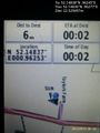
Proof. @52.1484,.9628
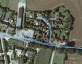
Track in Google Earth


Achievements
Sourcerer earned the OpenStreetMap achievement
|
Sourcerer earned the Midnight Geohash achievement
|
Expeditions and Plans
| 2015-09-13 | ||
|---|---|---|
| Colac, Australia | Benjamin Kaiser | Farm near Inverleigh. |
| Kaiserslautern, Germany | strongblackcoffee | On the edge of Münchweiler am Klingbach |
| Cambridge, United Kingdom | Sourcerer | A front drive at Battisford Tye, Suffolk, UK - hindering.bronzer.printout. |
Sourcerer's Expedition Links
2015-09-12 52 0 - 2015-09-13 52 0 - 2015-09-16 52 1 - KML file download of Sourcerer's expeditions for use with Google Earth.