Difference between revisions of "2015-09-16 47 -122"
imported>Thomcat (Mid-day, time to blow the dust off) |
imported>FippeBot m (Location) |
||
| (One intermediate revision by one other user not shown) | |||
| Line 19: | Line 19: | ||
== Expedition == | == Expedition == | ||
<!-- how it all turned out. your narrative goes here. --> | <!-- how it all turned out. your narrative goes here. --> | ||
| + | Easy drive from work, though to reach the access road you must drive miles past the hashpoint and backtrack. Turned off in Monroe, driving past the high school and penitentiary. | ||
| + | |||
| + | Reached the end of the google street-view driven road (though the sign is now missing) and shortly after that the end of the county-maintained road. Despite prominent no-parking signs, there was a line of cars next to the gate - I slotted in among them and exchanged my shoes for hiking shoes. A few people passed me, one with a dog, all commented on how nice a day it was. | ||
| + | |||
| + | Reaching the meadow involved hiking up a fairly steep hill. I paused on the way up to sight along the natural gas pipeline. | ||
| + | |||
| + | After that, things opened up into the glorious meadow. I went to where a double circle is on the linked PDF (above); this is either the start or end of the course (or both). From there I approached the point itself. | ||
| + | |||
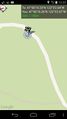
| + | Around the bend of the road, the GPS led me up a hillock, to a particular tree. I speared the poster onto a broken branch and leaned my map above it for a picture. I also did a few screen captures, as geohashdroid was not allowing upload access. Later I tested access to a previously successful geohash (did I screw up the page when I added text earlier?) but alas, it seems to be the app that is now broken. I have since found that this is due to a change on the wiki involving recaptcha... | ||
| + | |||
| + | Next I found the indicated rough trail and followed it down to the orienteering course. This was a work day, so I wasn't going to follow the whole course (which also involved a lot more hill climbing!), but I did find the spots for point 8, 9, and 10. Point 8 was situated near a bridge and a serene pond. | ||
| + | |||
| + | Between 9 and 10 I glanced back across the meadow and picked out a very small spot of white. I snapped a picture and indeed a few white pixels are in the photo. My geohash marker? Most likely - there wasn't a lot of other white out there. | ||
| + | |||
| + | A most satisfying geohash adventure on a beautiful day! | ||
== Tracklog == | == Tracklog == | ||
| Line 27: | Line 42: | ||
Image:2012-##-## ## ## Alpha.jpg | Witty Comment | Image:2012-##-## ## ## Alpha.jpg | Witty Comment | ||
--> | --> | ||
| − | <gallery perrow=" | + | <gallery perrow="4"> |
| + | |||
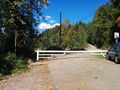
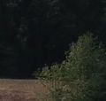
| + | Image:2015-09-16_47_-122_EndOfRoad.jpg | We walk from here | ||
| + | Image:2015-09-16_47_-122_DroidScreen1.jpg | Err... error? | ||
| + | Image:2015-09-16_47_-122_GasPipeline.jpg | A gas pipeline runs down the hill | ||
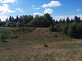
| + | Image:2015-09-16_47_-122_BroadMeadow.jpg | Likely orienteering kickoff spot | ||
| + | Image:2015-09-16_47_-122_HashPoint.jpg | Hash tree | ||
| + | Image:2015-09-16_47_-122_OnPoint.jpg | GPS says good | ||
| + | Image:2015-09-16_47_-122_OnPointError.jpg | Upload says no good | ||
| + | Image:2015-09-16_47_-122_Geohasher.jpg | Grin regardless | ||
| + | Image:2015-09-16_47_-122_OrienteeringLocation.jpg | Likely point 8 of orienteering course | ||
| + | Image:2015-09-16_47_-122_OrienteeringLake.jpg | Unnamed pond or lake at point 8 | ||
| + | Image:2015-09-16_47_-122_TowardsHashpoint.jpg | View across meadow to hashpoint | ||
| + | Image:2015-09-16_47_-122_Marker.jpg | My geohash marker? | ||
| + | |||
</gallery> | </gallery> | ||
| Line 35: | Line 64: | ||
| − | |||
| − | |||
| − | |||
[[Category:Expeditions]] | [[Category:Expeditions]] | ||
[[Category:Expeditions with photos]] | [[Category:Expeditions with photos]] | ||
[[Category:Coordinates reached]] | [[Category:Coordinates reached]] | ||
| − | + | {{location|US|WA|SN}} | |
| − | |||
| − | |||
| − | |||
| − | |||
| − | |||
| − | |||
| − | |||
| − | |||
| − | |||
| − | |||
Latest revision as of 05:09, 15 August 2019
| Wed 16 Sep 2015 in Seattle: 47.8386745, -122.0507337 geohashing.info google osm bing/os kml crox |
Location
Near an Orienteering course in the south corner of Lord Hill Regional Park, between Monroe and Snohomish.
Participants
Plans
Stop by midday.
Expedition
Easy drive from work, though to reach the access road you must drive miles past the hashpoint and backtrack. Turned off in Monroe, driving past the high school and penitentiary.
Reached the end of the google street-view driven road (though the sign is now missing) and shortly after that the end of the county-maintained road. Despite prominent no-parking signs, there was a line of cars next to the gate - I slotted in among them and exchanged my shoes for hiking shoes. A few people passed me, one with a dog, all commented on how nice a day it was.
Reaching the meadow involved hiking up a fairly steep hill. I paused on the way up to sight along the natural gas pipeline.
After that, things opened up into the glorious meadow. I went to where a double circle is on the linked PDF (above); this is either the start or end of the course (or both). From there I approached the point itself.
Around the bend of the road, the GPS led me up a hillock, to a particular tree. I speared the poster onto a broken branch and leaned my map above it for a picture. I also did a few screen captures, as geohashdroid was not allowing upload access. Later I tested access to a previously successful geohash (did I screw up the page when I added text earlier?) but alas, it seems to be the app that is now broken. I have since found that this is due to a change on the wiki involving recaptcha...
Next I found the indicated rough trail and followed it down to the orienteering course. This was a work day, so I wasn't going to follow the whole course (which also involved a lot more hill climbing!), but I did find the spots for point 8, 9, and 10. Point 8 was situated near a bridge and a serene pond.
Between 9 and 10 I glanced back across the meadow and picked out a very small spot of white. I snapped a picture and indeed a few white pixels are in the photo. My geohash marker? Most likely - there wasn't a lot of other white out there.
A most satisfying geohash adventure on a beautiful day!
Tracklog
Photos
We walk from here
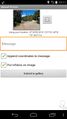
Err... error?
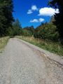
A gas pipeline runs down the hill
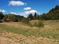
Likely orienteering kickoff spot
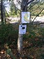
Hash tree
GPS says good

Upload says no good

Grin regardless
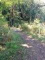
Likely point 8 of orienteering course
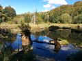
Unnamed pond or lake at point 8
View across meadow to hashpoint
My geohash marker?


