Difference between revisions of "2015-10-01 52 9"
From Geohashing
imported>GeorgDerReisende (new expedition) |
m (Adding hours) |
||
| (9 intermediate revisions by 3 users not shown) | |||
| Line 1: | Line 1: | ||
| − | |||
| − | |||
| − | |||
| − | |||
| − | |||
| − | |||
| − | |||
| − | |||
| − | |||
| − | |||
{{meetup graticule | {{meetup graticule | ||
| − | | lat=52 | + | |lat = 52 |
| − | | lon=9 | + | |lon = 9 |
| − | | date=2015-10-01 | + | |date = 2015-10-01 |
| + | |graticule_name = Hannover | ||
| + | |graticule_link = Hannover, Germany | ||
}} | }} | ||
| − | + | ==Location== | |
| − | + | The Geohash lies in the [[wikipedia:Eilenriede|Eilenriede]] forest in [[wikipedia:Hannover#Subdivisions|Hannover-Kleefeld]]. | |
| + | |||
| + | ==Participants== | ||
| + | *[[User:GeorgDerReisende|GeorgDerReisende]] | ||
| + | *[[User:Fippe|Fippe]] | ||
| − | == | + | ==Plans== |
| − | + | ===GeorgDerReisende=== | |
| + | Hitchhiking, walking, public transport. I try to be there at hash o'clock. | ||
| − | == | + | ===Fippe=== |
| − | + | Get to the tram station ''Uhlhornstraße'', walk from there. I will be there in the morning and hope that this is a "good" forest and I won't have to fight through stinging nettles. :D | |
| − | |||
| − | == | + | ==Expeditions== |
| − | + | ===Fippe=== | |
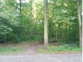
| + | It was a nice Geohash. Although Google Maps doesn't show any paths, there are some. The Coordinates are a couple of meters away from one path at the closest. I had to walk through some blackberries, but the bushes weren't very high, and arrived at the coordinates. | ||
| − | == | + | ===GeorgDerReisende=== |
| − | |||
| − | == | + | {| |
| − | + | |- | |
| + | ! style="width:300px" | !! style="width:300px" | !! style="width:300px" | | ||
| + | |- | ||
| + | | [[Image:2015-10-01 52 9 GeorgDerReisende 1516.jpg | 300px ]] || [[Image:2015-10-01 52 9 GeorgDerReisende 1525.jpg | 300px ]] || [[Image:2015-10-01 52 9 GeorgDerReisende 1526.jpg | 300px ]] | ||
| + | |- | ||
| + | | colspan = 3 | In the night a tooth broke out and I had to change my plany. I had at first an appointment with a dentist. Then I thought, it would be a not so good idea to hitchhike to Hannover with the feelings of an anesthetic injection and decided to take the train. I arrived at Hannover and took the underground/tram to the Pferdeturm and walked to the hash. At first I had a broad tarred way into the forest, but near the hash I found some usual tracks into the area, and my one got better. | ||
| + | |- | ||
| + | | [[Image:2015-10-01 52 9 GeorgDerReisende 1529.jpg | 300px ]] || [[Image:2015-10-01 52 9 GeorgDerReisende 1534.jpg | 300px ]] || | ||
| + | |- | ||
| + | | colspan = 3 | Some minutes later I was nine meters away. A dance under the trees, between young birches, nettles and blackcurrent strings, led me to the zero meter mark. And I looked around: | ||
| + | |- | ||
| + | | [[Image:2015-10-01 52 9 GeorgDerReisende 1535.jpg | 300px ]] the west || [[Image:2015-10-01 52 9 GeorgDerReisende 1536.jpg | 300px ]] the north || [[Image:2015-10-01 52 9 GeorgDerReisende 1537.jpg | 300px ]] the east | ||
| + | |- | ||
| + | | [[Image:2015-10-01 52 9 GeorgDerReisende 1538.jpg | 300px ]] the south || [[Image:2015-10-01 52 9 GeorgDerReisende 1540.jpg | 300px ]] the second geohasher || | ||
| + | |- | ||
| + | | [[Image:2015-10-01 52 9 GeorgDerReisende 1616.jpg | 300px ]] || [[Image:2015-10-01 52 9 GeorgDerReisende 1620.jpg | 300px ]] || | ||
| + | |- | ||
| + | | colspan = 3 | Because I arrived before hash o'clock and I wanted to wait for other geohashers I looked for a good place and found this canapé. I waited until 15 minutes past the time, then I wrote a mark on the nearest tree and went away.<br>I think, tomorrow I can get a new camera, so in the future I can take better photos again. | ||
| + | |} | ||
| − | == Photos == | + | ==Photos== |
| − | < | + | ===Fippe=== |
| − | + | <gallery> | |
| − | -- | + | 2015-10-01 52 09 01 Street.jpg | A street name sign near the forest |
| − | + | 2015-10-01 52 09 02 Path.jpg | The path leading into the forest | |
| + | 2015-10-01 52 09 03 Geohash.jpg | The Geohash | ||
| + | 2015-10-01 52 09 04 Proof.png | Proof | ||
| + | 2015-10-01 52 09 05 Forest.jpg | The forest | ||
| + | 2015-10-01 52 09 06 Forest.jpg | ||
| + | 2015-10-01 52 09 07 Forest.jpg | ||
| + | 2015-10-01 52 09 09 Branches.jpg | A pile of branches in the forest | ||
</gallery> | </gallery> | ||
| − | == Achievements == | + | ==Achievements== |
| − | {{#vardefine:ribbonwidth| | + | {{#vardefine:ribbonwidth|100%}} |
| − | + | {{land geohash|latitude=52|longitude=9|date=2015-10-01|name=[[User:Fippe|Fippe]] and [[User:GeorgDerReisende|GeorgDerReisende]] }} | |
| − | + | __NOTOC__ | |
| − | |||
| − | |||
| − | |||
| − | |||
| − | |||
| − | |||
| − | |||
| − | |||
| − | |||
| − | |||
| − | |||
[[Category:Expeditions]] | [[Category:Expeditions]] | ||
| − | + | [[Category:Coordinates reached]] | |
[[Category:Expeditions with photos]] | [[Category:Expeditions with photos]] | ||
| − | + | {{location|DE|NI|H}} | |
| − | + | {{user categories|user=Fippe|tram=13|foot=1|hours=08}} | |
| − | |||
| − | |||
| − | |||
| − | |||
| − | |||
| − | |||
| − | |||
| − | |||
| − | |||
| − | |||
| − | |||
| − | |||
| − | |||
| − | |||
| − | |||
| − | |||
| − | |||
| − | |||
| − | |||
| − | |||
| − | |||
| − | |||
Latest revision as of 19:04, 11 December 2022
| Thu 1 Oct 2015 in Hannover: 52.3677279, 9.7944354 geohashing.info google osm bing/os kml crox |
Location
The Geohash lies in the Eilenriede forest in Hannover-Kleefeld.
Participants
Plans
GeorgDerReisende
Hitchhiking, walking, public transport. I try to be there at hash o'clock.
Fippe
Get to the tram station Uhlhornstraße, walk from there. I will be there in the morning and hope that this is a "good" forest and I won't have to fight through stinging nettles. :D
Expeditions
Fippe
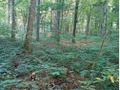
It was a nice Geohash. Although Google Maps doesn't show any paths, there are some. The Coordinates are a couple of meters away from one path at the closest. I had to walk through some blackberries, but the bushes weren't very high, and arrived at the coordinates.
GeorgDerReisende
 |
 |

|
| In the night a tooth broke out and I had to change my plany. I had at first an appointment with a dentist. Then I thought, it would be a not so good idea to hitchhike to Hannover with the feelings of an anesthetic injection and decided to take the train. I arrived at Hannover and took the underground/tram to the Pferdeturm and walked to the hash. At first I had a broad tarred way into the forest, but near the hash I found some usual tracks into the area, and my one got better. | ||
 |
 |
|
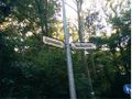
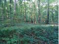
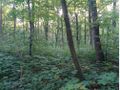
| Some minutes later I was nine meters away. A dance under the trees, between young birches, nettles and blackcurrent strings, led me to the zero meter mark. And I looked around: | ||
 the west the west |
 the north the north |
 the east the east
|
 the south the south |
 the second geohasher the second geohasher |
|
 |
 |
|
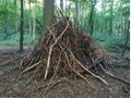
| Because I arrived before hash o'clock and I wanted to wait for other geohashers I looked for a good place and found this canapé. I waited until 15 minutes past the time, then I wrote a mark on the nearest tree and went away. I think, tomorrow I can get a new camera, so in the future I can take better photos again. | ||
Photos
Fippe
A street name sign near the forest
The path leading into the forest
The Geohash
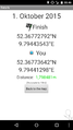
Proof
The forest
A pile of branches in the forest


Achievements
Fippe and GeorgDerReisende earned the Land geohash achievement
|