Difference between revisions of "2015-11-04 47 -122"
imported>Thomcat (OtherJack's old neighborhood. Can easily get within NWoodruff's 10 meters, not sure if I can reach the spot) |
imported>FippeBot m (Location) |
||
| (2 intermediate revisions by one other user not shown) | |||
| Line 15: | Line 15: | ||
== Plans == | == Plans == | ||
| − | Visit around lunchtime. Can easily get within [[User:NWoodruff| | + | Visit around lunchtime. Can easily get within [[User:NWoodruff|10 meters]], but not sure if I can actually reach the spot. Red Mill burgers just up the hill, Spud not far from the bottom of the hill. |
== Expedition == | == Expedition == | ||
<!-- how it all turned out. your narrative goes here. --> | <!-- how it all turned out. your narrative goes here. --> | ||
| + | This is a neighborhood I know well, having lived just blocks away. After visiting the geohash, I snapped pictures of a long children's slide and the air-raid siren. But I started with a snapshot of Green Lake. | ||
| + | |||
| + | Parked nearby on a clear and chilly day. A very bikeable location, but work and customer calls limited my free time today. | ||
| + | |||
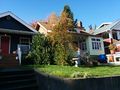
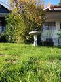
| + | The hashpoint was located in front and between the two houses, roughly in the pictured bush. Though the google and zillow overview showed it to be on the northern property, it actually ended up being on the southern. A quick visit to the porch found nobody home and the geohash reached with only a lean into said bush. | ||
| + | |||
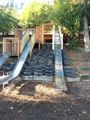
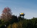
| + | Afterward I visited the active daycare center and slide (conveniently utilizing the hillside) and siren. Hashed out, I then headed to lunch. Though Red Mill and Zeke's tempted me, I ended up a Spud. Quite an easy success, followed by a yummy lunch. | ||
== Tracklog == | == Tracklog == | ||
| Line 27: | Line 34: | ||
Image:2012-##-## ## ## Alpha.jpg | Witty Comment | Image:2012-##-## ## ## Alpha.jpg | Witty Comment | ||
--> | --> | ||
| − | <gallery perrow=" | + | <gallery perrow="4"> |
| + | Image:2015-11-04_47_-122_LakeView.jpg | View of Greenlake | ||
| + | Image:2015-11-04_47_-122_FromSidewalk.jpg | ||
| + | Image:2015-11-04_47_-122_FromSidewalkLean.jpg | ||
| + | Image:2015-11-04_47_-122_OnSidewalk.jpg | Close enough for some... | ||
| + | Image:2015-11-04_47_-122_OnPoint.jpg | ... but not for me | ||
| + | Image:2015-11-04_47_-122_Geohasher.jpg | ||
| + | Image:2015-11-04_47_-122_LongSlide.jpg | ||
| + | Image:2015-11-04_47_-122_AirRaidSiren.jpg | ||
</gallery> | </gallery> | ||
| Line 34: | Line 49: | ||
<!-- Add any achievement ribbons you earned below, or remove this section --> | <!-- Add any achievement ribbons you earned below, or remove this section --> | ||
| − | |||
| − | |||
| − | |||
| − | |||
[[Category:Expeditions]] | [[Category:Expeditions]] | ||
[[Category:Expeditions with photos]] | [[Category:Expeditions with photos]] | ||
[[Category:Coordinates reached]] | [[Category:Coordinates reached]] | ||
| − | + | {{location|US|WA|KN}} | |
| − | |||
| − | |||
| − | |||
| − | |||
| − | |||
| − | |||
| − | |||
| − | |||
| − | |||
| − | |||
Latest revision as of 05:40, 15 August 2019
| Wed 4 Nov 2015 in Seattle: 47.6780037, -122.3528800 geohashing.info google osm bing/os kml crox |
Location
Near a house on Phinney Ridge, just north of the PNA.
Participants
Plans
Visit around lunchtime. Can easily get within 10 meters, but not sure if I can actually reach the spot. Red Mill burgers just up the hill, Spud not far from the bottom of the hill.
Expedition
This is a neighborhood I know well, having lived just blocks away. After visiting the geohash, I snapped pictures of a long children's slide and the air-raid siren. But I started with a snapshot of Green Lake.
Parked nearby on a clear and chilly day. A very bikeable location, but work and customer calls limited my free time today.
The hashpoint was located in front and between the two houses, roughly in the pictured bush. Though the google and zillow overview showed it to be on the northern property, it actually ended up being on the southern. A quick visit to the porch found nobody home and the geohash reached with only a lean into said bush.
Afterward I visited the active daycare center and slide (conveniently utilizing the hillside) and siren. Hashed out, I then headed to lunch. Though Red Mill and Zeke's tempted me, I ended up a Spud. Quite an easy success, followed by a yummy lunch.
Tracklog
Photos
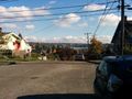
View of Greenlake
Close enough for some...
... but not for me