Difference between revisions of "2016-04-01 49 8"
imported>Q-Owl (Created page with "thumb|left|xxx xxx {{meetup graticule | lat=49 | lon=8 | date=2016-04-01 }}__NOTOC__ == Location == A hashpoint near wikipedia:Grünstadt|...") |
imported>FippeBot m (Location) |
||
| (11 intermediate revisions by 2 users not shown) | |||
| Line 1: | Line 1: | ||
| − | [[Image:2016-04-01 49 8 | + | [[Image:2016-04-01 49 8 w.jpg|thumb|left|Hashpoint and view west]] |
{{meetup graticule | {{meetup graticule | ||
| lat=49 | | lat=49 | ||
| Line 12: | Line 12: | ||
*[[User:Q-Owl|Q-Owl]] | *[[User:Q-Owl|Q-Owl]] | ||
| + | *[[User:DODO|DODO]] | ||
== Plan == | == Plan == | ||
| Line 18: | Line 19: | ||
== Expedition == | == Expedition == | ||
| + | '''Q-Owl:''' | ||
| + | Success! :-) | ||
| + | |||
| + | I crossed the river Rhine on the highway and drove near the hashpoint. There was a parking lot next to it. I hung up my jacket at the hashpoint, took a few photos and found about 8 geocaches on the way back to the Rhine. After a ferry trip I visited our nice and drove back home. | ||
| + | |||
| + | I did not think, that DODO would walk so far.^^ Otherwise I would have informend him bx e-mail. :-( | ||
| + | |||
| + | |||
| + | '''DODO:''' | ||
| + | |||
| + | The (planned) last hash on my tour was on the other side of the Rhine and I obviously couldn't walk all the way. So I planned to go to Worms by train and walk from there. But first I had to walk to the station. I had 3.7 kilometers to the station in Darmstadt-Eberstadt and I reached the station 7 minutes before the train should depart. Just enough time to find the ticket machine and get the ticket. I changed trains in Bensheim and reached Worms around 11. So I was back at the place where the tour started 4 days ago. First I walked into the city to buy some additional food before I walked outside the town. Soon I reached a rivulet and followed it for more than an hour before I reached Pfeddersheim. | ||
| − | + | From here I had to walk through the lower Palatine fields. Only fields and paths between them. Hardly even a bigger stone or a log to sit down for a break. It had rained a lot last night and so most of the paths were very muddy. Nevertheless I walked all the way and reached the hash-point at 4 pm. I would have left a mark if I had known that Q-Owl wanted to come, but I thought it would be to far from his home. | |
| − | |||
| − | I | ||
| − | |||
| − | |||
| − | + | I checked tomorrows hash-point and to my surprise it was almost on my way home. And on the top of that there was a very good hotel only 500 m from the hash and only 150 m from the station, from where I had to ride home. So I decided to stay another night away and visit tomorrows hash-point on my ride home. | |
| − | |||
== Photos == | == Photos == | ||
<gallery perrow="5" > | <gallery perrow="5" > | ||
Image:2016-04-01 49 8 p.png | Proof | Image:2016-04-01 49 8 p.png | Proof | ||
| − | Image:2016-04-01 49 8 w.jpg | View W | + | Image:2016-04-01 49 8 w.jpg | View W with my jacket at the hp |
| − | Image:2016-04-01 49 8 n.jpg | View N | + | Image:2016-04-01 49 8 n.jpg | View N |
| − | Image:2016-04-01 49 8 e.jpg | View E | + | Image:2016-04-01 49 8 e.jpg | View E with pink almond tree |
Image:2016-04-01 49 8 s.jpg | View S | Image:2016-04-01 49 8 s.jpg | View S | ||
Image:2016-04-01 49 8 g.jpg | Grin | Image:2016-04-01 49 8 g.jpg | Grin | ||
| Line 45: | Line 52: | ||
== Achievements == | == Achievements == | ||
| − | {{#vardefine:ribbonwidth| | + | {{#vardefine:ribbonwidth|700px}}{{land geohash |
| latitude = 49 | | latitude = 49 | ||
| longitude = 8 | | longitude = 8 | ||
| date = 2016-04-01 | | date = 2016-04-01 | ||
| − | | name = Q-Owl | + | | name = DODO and Q-Owl |
}} | }} | ||
| + | {{gratuitous ribbon | ||
| + | | icon = Avoid achievement.png | ||
| + | | latitude = 49 | ||
| + | | longitude = 8 | ||
| + | | date = 2016-04-01 | ||
| + | | achievement = Avoid Each Other Achievement | ||
| + | | description = launching two independent expeditions without meeting up at the | ||
| + | | name = DODO and Q-Owl | ||
| + | }} | ||
| + | |||
| + | |||
{{consecutive geohash 2 | {{consecutive geohash 2 | ||
| count = 2 | | count = 2 | ||
| Line 58: | Line 76: | ||
| name = Q-Owl | | name = Q-Owl | ||
}} | }} | ||
| + | |||
| + | |||
| + | {{consecutive geohash 2 | ||
| + | | count = 5 | ||
| + | | latitude = 49 | ||
| + | | longitude = 8 | ||
| + | | date = 2016-03-28 | ||
| + | | name = DODO | ||
| + | }} | ||
| + | |||
== Other Geohashing Expeditions and Plans on this Day == | == Other Geohashing Expeditions and Plans on this Day == | ||
{{expedition summaries|2016-04-01}} | {{expedition summaries|2016-04-01}} | ||
| − | |||
<!-- =============== USEFUL CATEGORIES FOLLOW ================ --> | <!-- =============== USEFUL CATEGORIES FOLLOW ================ --> | ||
| Line 81: | Line 108: | ||
[[Category: Meetup on 2016-04-01]] | [[Category: Meetup on 2016-04-01]] | ||
[[Category: Meetup in 49 8]] | [[Category: Meetup in 49 8]] | ||
| + | {{location|DE|RP|DÜW}} | ||
Latest revision as of 00:05, 16 August 2019

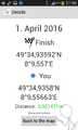
| Fri 1 Apr 2016 in 49,8: 49.5822653, 8.1592834 geohashing.info google osm bing/os kml crox |
Location
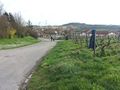
A hashpoint near Grünstadt on the left side of the Rhine valley.
Participants
Plan
Drive near the hashpoint, find it, walk back to the car, find some geocaches and drive home.
Expedition
Q-Owl: Success! :-)
I crossed the river Rhine on the highway and drove near the hashpoint. There was a parking lot next to it. I hung up my jacket at the hashpoint, took a few photos and found about 8 geocaches on the way back to the Rhine. After a ferry trip I visited our nice and drove back home.
I did not think, that DODO would walk so far.^^ Otherwise I would have informend him bx e-mail. :-(
DODO:
The (planned) last hash on my tour was on the other side of the Rhine and I obviously couldn't walk all the way. So I planned to go to Worms by train and walk from there. But first I had to walk to the station. I had 3.7 kilometers to the station in Darmstadt-Eberstadt and I reached the station 7 minutes before the train should depart. Just enough time to find the ticket machine and get the ticket. I changed trains in Bensheim and reached Worms around 11. So I was back at the place where the tour started 4 days ago. First I walked into the city to buy some additional food before I walked outside the town. Soon I reached a rivulet and followed it for more than an hour before I reached Pfeddersheim.
From here I had to walk through the lower Palatine fields. Only fields and paths between them. Hardly even a bigger stone or a log to sit down for a break. It had rained a lot last night and so most of the paths were very muddy. Nevertheless I walked all the way and reached the hash-point at 4 pm. I would have left a mark if I had known that Q-Owl wanted to come, but I thought it would be to far from his home.
I checked tomorrows hash-point and to my surprise it was almost on my way home. And on the top of that there was a very good hotel only 500 m from the hash and only 150 m from the station, from where I had to ride home. So I decided to stay another night away and visit tomorrows hash-point on my ride home.
Photos
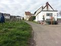
Proof
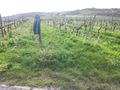
View W with my jacket at the hp
View N
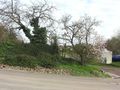
View E with pink almond tree
View S

Grin


Achievements
DODO and Q-Owl earned the Land geohash achievement
|
DODO and Q-Owl earned the Avoid Each Other Achievement
|
Q-Owl earned the Consecutive geohash achievement
|
DODO earned the Consecutive geohash achievement
|
Other Geohashing Expeditions and Plans on this Day
Expeditions and Plans
| 2016-04-01 | ||
|---|---|---|
| Mannheim, Germany | Q-Owl, DODO | A hashpoint near Grünstadt on the left side of the Rhine valley. |
| Norwich, United Kingdom | Sourcerer | A field near Kett's Oak, Norfolk, UK. |