Difference between revisions of "2008-05-30 1 103"
imported>R0d3n7z (new expedition) |
m (fix, sorry) |
||
| (9 intermediate revisions by 5 users not shown) | |||
| Line 12: | Line 12: | ||
Jurong Industrial Estate in Singapore, across the AYE from [[wikipedia:Jurong BirdPark|Jurong BirdPark]]. To be precise, the spot is inside Caterpillar Asia Pte Ltd at 7 Tractor Road, off Jln Boon Lay / Jln Ahmad Ibrahim. Reachable by bus 194, 249, 251 or 252 from Boon Lay Interchange, plus a short walk. | Jurong Industrial Estate in Singapore, across the AYE from [[wikipedia:Jurong BirdPark|Jurong BirdPark]]. To be precise, the spot is inside Caterpillar Asia Pte Ltd at 7 Tractor Road, off Jln Boon Lay / Jln Ahmad Ibrahim. Reachable by bus 194, 249, 251 or 252 from Boon Lay Interchange, plus a short walk. | ||
| − | This marks the first "accessible" geohash on land in Singapore since the algorithm was published in xkcd comic #426, and the first geohashing expedition in Singapore. (The | + | This marks the first "accessible" geohash on land in Singapore since the algorithm was published in xkcd comic #426, and the first geohashing expedition in Singapore. (The {{egl|2008-05-23|1|103|text=coordinates for 2008-05-23}} were on land, but inside a military training area so access was restricted.) |
==Expeditions== | ==Expeditions== | ||
===[[User:R0d3n7z|r0d3n7z]]=== | ===[[User:R0d3n7z|r0d3n7z]]=== | ||
| + | |||
| + | [http://maps.google.com/maps/ms?msa=0&msid=108926863438721193959.0004502ca403cf41cc52e&t=k&z=17&ll=1.322641,103.705648 Expedition route on Google Maps] | ||
Don't have GPS, but was able to get within about 15-20 meters (50-65 feet) ([http://maps.google.com/maps?f=q&hl=en&geocode=&q=1.322725,+103.704455&ie=UTF8&ll=1.322727,103.704457&spn=0.00406,0.005021&t=k&z=18&iwloc=addr loc]) of the exact point using aerial photograph from Google Maps. | Don't have GPS, but was able to get within about 15-20 meters (50-65 feet) ([http://maps.google.com/maps?f=q&hl=en&geocode=&q=1.322725,+103.704455&ie=UTF8&ll=1.322727,103.704457&spn=0.00406,0.005021&t=k&z=18&iwloc=addr loc]) of the exact point using aerial photograph from Google Maps. | ||
| − | Reached the area by public transport at around 16:50 local time. Scouted out the Caterpillar Asia compound, found double-gated security at the main entrance, conspicuous warning | + | Reached the area by public transport at around 16:50 local time. Scouted out the Caterpillar Asia compound, found double-gated security at the main entrance, conspicuous warning signs, and lots of security cameras. Unable to gain access, I flanked south and made my way to the park connector ([http://maps.google.com/maps?f=q&hl=en&geocode=&q=1.32235,+103.70433&ie=UTF8&t=k&z=17&iwloc=addr loc]) (actually just a simple bicycle/running track) that runs along the west side of the compound, got there at around 17:00. |
| − | The southwest corner of the compound fence was reachable by climbing a short slope, it is adjacent to a small electrical substation on AYE / Jln Ahmad Ibrahim. Judging from Google Maps, the exact point is inside the southwest corner of the building. | + | The southwest corner of the compound fence was reachable by climbing a short slope, it is adjacent to a small electrical substation ([http://maps.google.com/maps?f=q&hl=en&geocode=&q=1.32235,+103.7045&ie=UTF8&ll=1.322351,103.7045&spn=0.00406,0.005021&t=k&z=18&iwloc=addr loc]) on AYE / Jln Ahmad Ibrahim. Judging from Google Maps, the exact point is inside the southwest corner of the building. |
| − | After stumbling across a dead bird, I found a way to walk along the south side of the fence, which I thought would get me closer to the point. (I was wrong, just discovered I'd misread the aerial photography when rechecking the map online.) Left a mark (in the wrong place!) by propping a dead branch against the fence and placing a flower ([http://maps.google.com/maps?f=q&hl=en&geocode=&q=1.3225,+103.7046&ie=UTF8&ll=1.322501,103.704602&spn=0.00406,0.005021&t=k&z=18&iwloc=addr loc]) -- ought to attract the attention of any observant person poking around the place, the flower came from a tree ([http://maps.google.com/maps?f=q&hl=en&geocode=&q=1.32235,+103.70467&ie=UTF8&ll=1.322351,103.704672&spn=0.00406,0.005021&t=k&z=18&iwloc=addr loc]) | + | After stumbling across a dead bird, I found a way to walk along the south side of the fence, which I thought would get me closer to the point. (I was wrong, just discovered I'd misread the aerial photography when rechecking the map online.) Left a mark (in the wrong place!) by propping a dead branch against the fence and placing a flower ([http://maps.google.com/maps?f=q&hl=en&geocode=&q=1.3225,+103.7046&ie=UTF8&ll=1.322501,103.704602&spn=0.00406,0.005021&t=k&z=18&iwloc=addr loc]) -- ought to attract the attention of any observant person poking around the place, the flower came from a tree ([http://maps.google.com/maps?f=q&hl=en&geocode=&q=1.32235,+103.70467&ie=UTF8&ll=1.322351,103.704672&spn=0.00406,0.005021&t=k&z=18&iwloc=addr loc]) 20 meters away. |
At this point (17:15), I started getting attacked by mosquitoes and decided to beat a hasty retreat. Crossed the expressway by means of overhead bridge ([http://maps.google.com/maps?f=q&hl=en&geocode=&q=1.32215,+103.70312&ie=UTF8&t=k&ll=1.322078,103.703433&spn=0.00406,0.005021&z=18&iwloc=addr loc]), snapped a couple more pictures from across the road showing the Caterpillar building and electrical substation. Took a short rest at Jurong BirdPark, helped some tourists who needed directions, then hopped onto bus 194 ([http://maps.google.com/maps?f=q&hl=en&geocode=11414543595191666604,1.321348,103.707732&q=1.321348,+103.707732&ie=UTF8&ll=1.321348,103.707732&spn=0.00406,0.005021&t=k&z=18 loc]) back to Boon Lay. | At this point (17:15), I started getting attacked by mosquitoes and decided to beat a hasty retreat. Crossed the expressway by means of overhead bridge ([http://maps.google.com/maps?f=q&hl=en&geocode=&q=1.32215,+103.70312&ie=UTF8&t=k&ll=1.322078,103.703433&spn=0.00406,0.005021&z=18&iwloc=addr loc]), snapped a couple more pictures from across the road showing the Caterpillar building and electrical substation. Took a short rest at Jurong BirdPark, helped some tourists who needed directions, then hopped onto bus 194 ([http://maps.google.com/maps?f=q&hl=en&geocode=11414543595191666604,1.321348,103.707732&q=1.321348,+103.707732&ie=UTF8&ll=1.321348,103.707732&spn=0.00406,0.005021&t=k&z=18 loc]) back to Boon Lay. | ||
| − | Pictures | + | <gallery caption="Pictures" widths="200px" heights="200px" perrow="3"> |
| + | Image:30052008-1-103-01compoundE.jpg| East side of the Caterpillar Asia compound. | ||
| + | Image:30052008-1-103-02warning.jpg| Conspicuous warning signs were posted, so another way had to be found. | ||
| + | Image:30052008-1-103-03park.jpg| Map posted at the start of Jurong Park Connector. | ||
| + | Image:30052008-1-103-04compoundSW.jpg| The southwest corner of the Caterpillar compound, as seen from the park connector. | ||
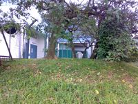
| + | Image:30052008-1-103-05subst.jpg| This electrical substation is visible on google maps at [http://maps.google.com/maps?f=q&hl=en&geocode=&q=1.32235,+103.7045&ie=UTF8&ll=1.322351,103.7045&spn=0.00406,0.005021&t=k&z=18&iwloc=addr 1.32235, 103.7045]. | ||
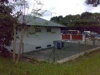
| + | Image:30052008-1-103-06pt1.jpg| It's somewhere in this building... | ||
| + | Image:30052008-1-103-07corpse.jpg| Stumbled across a dead bird. | ||
| + | Image:30052008-1-103-08acc.jpg| Hmm, a way to get closer to the actual spot? (Wrong!) | ||
| + | Image:30052008-1-103-09pt2.jpg| Yup, it's somewhere in there... | ||
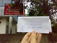
| + | Image:30052008-1-103-10mark.jpg| Left a marker, but it's in the wrong place. >_<;; | ||
| + | Image:30052008-1-103-11opp1.jpg| View from across the road showing relative location of the electrical substation. | ||
| + | Image:30052008-1-103-12opp2.jpg| The flower for my marker came from that tree you can see just behind the cab of the green truck. | ||
| + | Image:30052008-1-103-13birdpark.jpg| Stopped by Jurong BirdPark on the way out. | ||
| + | </gallery> | ||
[[Category:Expeditions]] | [[Category:Expeditions]] | ||
| + | [[Category:Expeditions with photos]] | ||
| + | [[Category:Coordinates not reached]] | ||
| + | [[Category:Not reached - No public access]] | ||
| + | [[Category:Expedition without GPS]] | ||
| + | {{location|SG|SW}} | ||
Latest revision as of 18:45, 18 January 2022
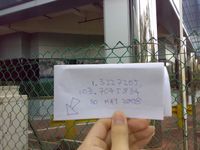
| Fri 30 May 2008 in 1,103: 1.3227205, 103.7045834 geohashing.info google osm bing/os kml crox |
About
1.3227205387098275, 103.7045834347042035
Jurong Industrial Estate in Singapore, across the AYE from Jurong BirdPark. To be precise, the spot is inside Caterpillar Asia Pte Ltd at 7 Tractor Road, off Jln Boon Lay / Jln Ahmad Ibrahim. Reachable by bus 194, 249, 251 or 252 from Boon Lay Interchange, plus a short walk.
This marks the first "accessible" geohash on land in Singapore since the algorithm was published in xkcd comic #426, and the first geohashing expedition in Singapore. (The coordinates for 2008-05-23 were on land, but inside a military training area so access was restricted.)
Expeditions
r0d3n7z
Expedition route on Google Maps
Don't have GPS, but was able to get within about 15-20 meters (50-65 feet) (loc) of the exact point using aerial photograph from Google Maps.
Reached the area by public transport at around 16:50 local time. Scouted out the Caterpillar Asia compound, found double-gated security at the main entrance, conspicuous warning signs, and lots of security cameras. Unable to gain access, I flanked south and made my way to the park connector (loc) (actually just a simple bicycle/running track) that runs along the west side of the compound, got there at around 17:00.
The southwest corner of the compound fence was reachable by climbing a short slope, it is adjacent to a small electrical substation (loc) on AYE / Jln Ahmad Ibrahim. Judging from Google Maps, the exact point is inside the southwest corner of the building.
After stumbling across a dead bird, I found a way to walk along the south side of the fence, which I thought would get me closer to the point. (I was wrong, just discovered I'd misread the aerial photography when rechecking the map online.) Left a mark (in the wrong place!) by propping a dead branch against the fence and placing a flower (loc) -- ought to attract the attention of any observant person poking around the place, the flower came from a tree (loc) 20 meters away.
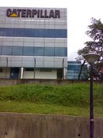
At this point (17:15), I started getting attacked by mosquitoes and decided to beat a hasty retreat. Crossed the expressway by means of overhead bridge (loc), snapped a couple more pictures from across the road showing the Caterpillar building and electrical substation. Took a short rest at Jurong BirdPark, helped some tourists who needed directions, then hopped onto bus 194 (loc) back to Boon Lay.
- Pictures
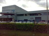
East side of the Caterpillar Asia compound.
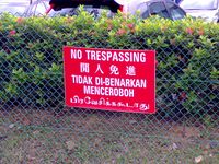
Conspicuous warning signs were posted, so another way had to be found.
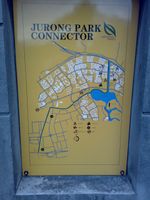
Map posted at the start of Jurong Park Connector.
The southwest corner of the Caterpillar compound, as seen from the park connector.
This electrical substation is visible on google maps at 1.32235, 103.7045.
It's somewhere in this building...
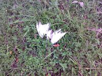
Stumbled across a dead bird.
Hmm, a way to get closer to the actual spot? (Wrong!)
Yup, it's somewhere in there...

Left a marker, but it's in the wrong place. >_<;;

View from across the road showing relative location of the electrical substation.
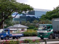
The flower for my marker came from that tree you can see just behind the cab of the green truck.

Stopped by Jurong BirdPark on the way out.


