Difference between revisions of "2016-04-16 52 1"
From Geohashing
imported>Sourcerer m ([live] Arrived.) |
m |
||
| (3 intermediate revisions by 2 users not shown) | |||
| Line 1: | Line 1: | ||
| − | + | {{meetup graticule | |
| − | |||
| − | |||
| − | |||
| − | |||
| − | |||
| − | |||
| − | |||
| − | |||
| − | |||
| − | {{meetup graticule | ||
| lat=52 | | lat=52 | ||
| lon=1 | | lon=1 | ||
| date=2016-04-16 | | date=2016-04-16 | ||
| + | | graticule_name=Norwich, UK | ||
| + | | graticule_link=Norwich, United Kingdom | ||
}} | }} | ||
| − | |||
| − | |||
__NOTOC__ | __NOTOC__ | ||
| + | == Location == | ||
| − | + | A back garden at the end of Romany Road, Norwich, UK. | |
| − | |||
== Participants == | == Participants == | ||
| − | |||
| − | |||
| − | + | *[[User:Sourcerer|Sourcerer]] | |
| − | |||
| − | == Expedition == | + | == Expedition - Fail == |
| − | |||
| + | *Arrived. -- [[User:Sourcerer|Sourcerer]] ([[User talk:Sourcerer|talk]]) [http://www.openstreetmap.org/?lat=52.64226258&lon=1.30897164&zoom=16&layers=B000FTF @52.6423,1.3090] 20:53, 16 April 2016 (GMT+01:00) | ||
| − | + | One vote out of three ... | |
| − | + | ||
| − | + | # Garmin said I was 9 metres from the destination. | |
| + | # Google Earth said I was 6 metres away. | ||
| + | # Geohash Droid said I was under 2 metres away. | ||
| + | |||
| + | The point of closest approach was on a footpath joining Romany Road to Gertrude Road. There was a very thick and tall hedge blocking the final approach. | ||
== Photos == | == Photos == | ||
| − | + | ||
| − | |||
| − | |||
<gallery perrow="5"> | <gallery perrow="5"> | ||
| + | Image:2016-04-16_52_1_Sourcerer_1460836281536.jpg | Evidence. [http://www.openstreetmap.org/?lat=52.64225721&lon=1.30897701&zoom=16&layers=B000FTF @52.6423,1.3090] | ||
| + | Image:2016-04-16_52_1_Sourcerer.jpg | Google Earth Track | ||
</gallery> | </gallery> | ||
== Achievements == | == Achievements == | ||
{{#vardefine:ribbonwidth|800px}} | {{#vardefine:ribbonwidth|800px}} | ||
| − | |||
| − | + | {{Sourcerer_links | |
| − | + | | prev = 2016-04-14 52 1 | |
| − | + | | curr = 2016-04-16 52 1 | |
| + | | next = 2016-04-17 52 1 | ||
| + | | date = 2016-04-16 | ||
| + | }} | ||
| − | |||
| − | |||
| − | |||
| − | |||
| − | |||
| − | |||
| − | |||
| − | |||
[[Category:Expeditions]] | [[Category:Expeditions]] | ||
| − | |||
[[Category:Expeditions with photos]] | [[Category:Expeditions with photos]] | ||
| − | |||
| − | |||
| − | |||
| − | |||
| − | |||
| − | |||
| − | |||
| − | |||
| − | |||
[[Category:Coordinates not reached]] | [[Category:Coordinates not reached]] | ||
| − | |||
| − | |||
| − | |||
| − | |||
| − | |||
[[Category:Not reached - No public access]] | [[Category:Not reached - No public access]] | ||
| − | + | {{location|GB|ENG|NFK}} | |
| − | |||
| − | |||
| − | |||
| − | |||
| − | |||
| − | |||
| − | |||
Latest revision as of 11:48, 27 March 2022
| Sat 16 Apr 2016 in Norwich, UK: 52.6422736, 1.3089662 geohashing.info google osm bing/os kml crox |
Location
A back garden at the end of Romany Road, Norwich, UK.
Participants
Expedition - Fail
- Arrived. -- Sourcerer (talk) @52.6423,1.3090 20:53, 16 April 2016 (GMT+01:00)
One vote out of three ...
- Garmin said I was 9 metres from the destination.
- Google Earth said I was 6 metres away.
- Geohash Droid said I was under 2 metres away.
The point of closest approach was on a footpath joining Romany Road to Gertrude Road. There was a very thick and tall hedge blocking the final approach.
Photos
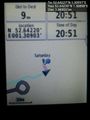
Evidence. @52.6423,1.3090
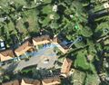
Google Earth Track


Achievements
Expeditions and Plans
| 2016-04-16 | ||
|---|---|---|
| Melbourne East, Australia | Kozz | Private property next to a public reserve in Christmas Hills / out the back... |
| Buffalo, New York | Pedalpusher | Next to...I kid you not...Yogi Bear's Jellystone Park, just off the road |
| Seattle, Washington | Thomcat | On the Montlake playfield, just south of the 520 bridge. |
| Mannheim, Germany | DODO | A graveyard in Worms-Leiselheim. |
| Norwich, United Kingdom | Sourcerer | A back garden at the end of Romany Road, Norwich, UK. |
Sourcerer's Expedition Links
2016-04-14 52 1 - 2016-04-16 52 1 - 2016-04-17 52 1 - KML file download of Sourcerer's expeditions for use with Google Earth.